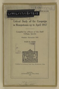
'Critical Study of the Campaign in Mesopotamia up to April 1917: Part II - Maps'
IOR/L/MIL/17/15/72/2


52 items in this record
Search within this record
The record is made up of 1 volume (25 folios). It was created in 1925. It was written in English. The original is part of the British Library: India Office The department of the British Government to which the Government of India reported between 1858 and 1947. The successor to the Court of Directors. Records and Private Papers Documents collected in a private capacity. .
About this record
- Content
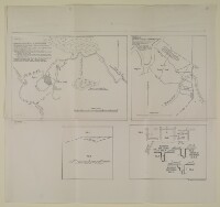
The volume is Critical Study of the Campaign in Mesopotamia up to April 1917. Compiled by officers of the Staff College, Quetta, October-November 1923. Part II - Maps (Calcutta: Government of India Press, 1925). The volume is published by the General Staff Army Headquarters, India.
The contents include a general map of Lower Mesopotamia; map of the battle of Ctesiphon; map of the battle of Shaikh Saad, 5-7 January 1916; map of the battle of the Wadi A seasonal or intermittent watercourse, or the valley in which it flows. ; map of the defences of Kut [Al-Kūt]; and situation maps charting the progress of the campaign.
- Extent and format
- 1 volume (25 folios)
- It is grouped into
- 2 imagesRef: IOR/L/MIL/17/15/72/2, f 12 imagesRef: IOR/L/MIL/17/15/72/2, f 22 imagesRef: IOR/L/MIL/17/15/72/2, f 32 imagesRef: IOR/L/MIL/17/15/72/2, f 42 imagesRef: IOR/L/MIL/17/15/72/2, f 52 imagesRef: IOR/L/MIL/17/15/72/2, f 62 imagesRef: IOR/L/MIL/17/15/72/2, f 72 imagesRef: IOR/L/MIL/17/15/72/2, f 82 imagesRef: IOR/L/MIL/17/15/72/2, f 92 imagesRef: IOR/L/MIL/17/15/72/2, f 102 imagesRef: IOR/L/MIL/17/15/72/2, f 112 imagesRef: IOR/L/MIL/17/15/72/2, f 122 imagesRef: IOR/L/MIL/17/15/72/2, f 132 imagesRef: IOR/L/MIL/17/15/72/2, f 142 imagesRef: IOR/L/MIL/17/15/72/2, f 152 imagesRef: IOR/L/MIL/17/15/72/2, f 162 imagesRef: IOR/L/MIL/17/15/72/2, f 172 imagesRef: IOR/L/MIL/17/15/72/2, f 182 imagesRef: IOR/L/MIL/17/15/72/2, f 192 imagesRef: IOR/L/MIL/17/15/72/2, f 202 imagesRef: IOR/L/MIL/17/15/72/2, f 212 imagesRef: IOR/L/MIL/17/15/72/2, f 222 imagesRef: IOR/L/MIL/17/15/72/2, f 232 imagesRef: IOR/L/MIL/17/15/72/2, f 242 imagesRef: IOR/L/MIL/17/15/72/2, f 25
- Arrangement
There is a list of the maps and sketches in this volume in Part I [IOR/L/MIL/17/15/72/1] (f 5), numbered 1-26, but they are not physically in the same order as their list number.
- Physical characteristics
Foliation: the foliation sequence commences at 1 on the first map and terminates at 25 on the last map. The numbers are written in pencil, are enclosed in a circle, and appear in the top right hand corner of the recto The front of a sheet of paper or leaf, often abbreviated to 'r'. page of each folio. Most of the maps and diagrams (ff 1, 3-5, 7-8, 10-18, 21-22, 24-25) need to be unfolded to be examined. This is the sequence that has been used to determine the order of pages. There is also an original printed reference number that appears in a similar position to the main foliation sequence. This relates to the list of maps and sketches in Part I, numbered 1-26. According to this list, one item is not present with the volume: '26. Explanation of the method of giving map co-ordinates adopted in Chapters XIII and XX'.
- Written in
- English in Latin script
- Type
- Archival file
Archive information for this record
- Original held at
- British Library: India Office The department of the British Government to which the Government of India reported between 1858 and 1947. The successor to the Court of Directors. Records and Private Papers Documents collected in a private capacity.
- Access conditions
Unrestricted
- Archive reference
- IOR/L/MIL/17/15/72/2
- Date(s)
- 1925 (CE, Gregorian)
Access & Reference
History of this record
Use and share this record
- Share this record
- Cite this record in your research
'Critical Study of the Campaign in Mesopotamia up to April 1917: Part II - Maps', British Library: India Office Records and Private Papers, IOR/L/MIL/17/15/72/2, in Qatar Digital Library <https://www.qdl.qa/archive/81055/vdc_100023193665.0x000001> [accessed 18 April 2024]
- Link to this record
https://www.qdl.qa/en/archive/81055/vdc_100023193665.0x000001
- IIIF details
This record has a IIIF manifest available as follows. If you have a compatible viewer you can drag the icon to load it.https://www.qdl.qa/en/iiif/81055/vdc_100023193665.0x000001/manifestOpen in Universal viewerOpen in Mirador viewerMore options for embedding images
Copyright: How to use this content
- Reference
- IOR/L/MIL/17/15/72/2
- Title
- 'Critical Study of the Campaign in Mesopotamia up to April 1917: Part II - Maps'
- Pages
- front, back
- Author
- East India Company, the Board of Control, the India Office, or other British Government Department
- Usage terms
- Open Government Licence
- Reference
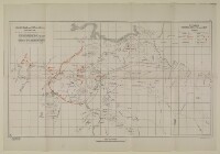
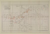
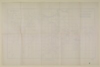
- IOR/L/MIL/17/15/72/2, f 1
- Title
- ‘19. Shaikh Saad and Kut-Al-Amara. Situation Night 25th-26th February 1917’
- Pages
- 1r:1v
- Author
- East India Company, the Board of Control, the India Office, or other British Government Department
- Usage terms
- Open Government Licence
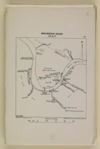
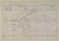
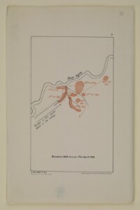
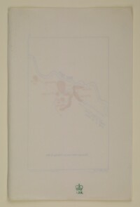
- Reference
- IOR/L/MIL/17/15/72/2, f 2
- Title
- ‘15. Shumran Bend’
- Pages
- 2r:2v
- Author
- East India Company, the Board of Control, the India Office, or other British Government Department
- Usage terms
- Open Government Licence
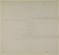
- Reference
- IOR/L/MIL/17/15/72/2, f 3
- Title
- ‘16. Shaikh Saad and Kut-Al-Amara. Situation 5 a.m. 23rd February 1917’
- Pages
- 3r:3v
- Author
- East India Company, the Board of Control, the India Office, or other British Government Department
- Usage terms
- Open Government Licence
- Reference
- IOR/L/MIL/17/15/72/2, f 4
- Title
- ‘17. Shaikh Saad and Kut-Al-Amara. Situation 4 a.m. 24th February 1917’
- Pages
- 4r:4v
- Author
- East India Company, the Board of Control, the India Office, or other British Government Department
- Usage terms
- Open Government Licence
- Reference
- IOR/L/MIL/17/15/72/2, f 5
- Title
- ‘18. Shaikh Saad and Kut-Al-Amara. Situation Night 24th-25th February 1917’
- Pages
- 5r:5v
- Author
- East India Company, the Board of Control, the India Office, or other British Government Department
- Usage terms
- Open Government Licence
- Reference
- IOR/L/MIL/17/15/72/2, f 6
- Title
- ‘25. Sketch Map of Istabulat’
- Pages
- 6r:6v
- Author
- East India Company, the Board of Control, the India Office, or other British Government Department
- Usage terms
- Open Government Licence
- Reference
- IOR/L/MIL/17/15/72/2, f 7
- Title
- ‘23. Baghdad – Samarra’
- Pages
- 7r:7v
- Author
- East India Company, the Board of Control, the India Office, or other British Government Department
- Usage terms
- Open Government Licence
- Reference
- IOR/L/MIL/17/15/72/2, f 8
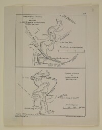
- Title
- ‘24. Diagram of the Crossing of Adhaim by 38th Brigade & Cassels Cavalry 17th/18th April 1917’ and ‘Diagram of Action at Band-i-Adhaim 30th April 1917’
- Pages
- 8r:8v
- Author
- East India Company, the Board of Control, the India Office, or other British Government Department
- Usage terms
- Open Government Licence
- Reference
- IOR/L/MIL/17/15/72/2, f 9
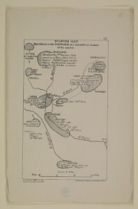
- Title
- ‘22. Operations in the Caucasus at a standstill on account of the weather. Situation 13-3.17’
- Pages
- 9r:9v
- Author
- East India Company, the Board of Control, the India Office, or other British Government Department
- Usage terms
- Open Government Licence
- Reference
- IOR/L/MIL/17/15/72/2, f 10
- Title
- ‘5. Battle of the Wadi’
- Pages
- 10r:10v
- Author
- East India Company, the Board of Control, the India Office, or other British Government Department
- Usage terms
- Open Government Licence
- Reference
- IOR/L/MIL/17/15/72/2, f 11
- Title
- ‘21. Diagram of situation on 9th-10th March (night)’
- Pages
- 11r:11v
- Author
- East India Company, the Board of Control, the India Office, or other British Government Department
- Usage terms
- Open Government Licence
- Reference
- IOR/L/MIL/17/15/72/2, f 12
- Title
- ‘2. Sketch of Country Round Shaiba to Illustrate Actions of 12th to 14th April’
- Pages
- 12r:12v
- Author
- East India Company, the Board of Control, the India Office, or other British Government Department
- Usage terms
- Open Government Licence
- Reference
- IOR/L/MIL/17/15/72/2, f 13
- Title
- ‘20. Diagram of situation on 7th March’
- Pages
- 13r:13v
- Author
- East India Company, the Board of Control, the India Office, or other British Government Department
- Usage terms
- Open Government Licence
- Reference
- IOR/L/MIL/17/15/72/2, f 14
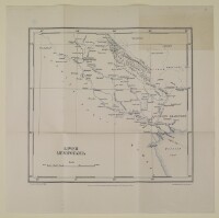
- Title
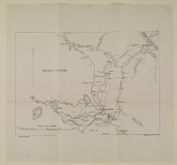
- ‘1. Lower Mesopotamia’
- Pages
- 14r:14v
- Author
- East India Company, the Board of Control, the India Office, or other British Government Department
- Usage terms
- Open Government Licence
- Reference
- IOR/L/MIL/17/15/72/2, f 15
- Title
- ‘6. Sketch Map of the Country Between Umm Al Hanna and Kut-Al-Amara Showing the Attack from the South on the Dujaila Redoubt. Compiled from the War Diary of Columns A and B Commanded by Major General G.V. Kemball, C.B., D.S.O., from 7th to 9th March 1916’
- Pages
- 15r:15v
- Author
- East India Company, the Board of Control, the India Office, or other British Government Department
- Usage terms
- Open Government Licence
- Reference
- IOR/L/MIL/17/15/72/2, f 16
- Title
- ‘3. Battle of Ctesiphon’
- Pages
- 16r:16v
- Author
- East India Company, the Board of Control, the India Office, or other British Government Department
- Usage terms
- Open Government Licence
- Reference
- IOR/L/MIL/17/15/72/2, f 17
- Title
- ‘4. Shaikh Saad and Kut-Al-Amara. Battle of Shaikh Saad 5th to 7th January 1916’
- Pages
- 17r:17v
- Author
- East India Company, the Board of Control, the India Office, or other British Government Department
- Usage terms
- Open Government Licence
- Reference
- IOR/L/MIL/17/15/72/2, f 18
- Title
- ‘7. Shaikh Saad and Kut-Al-Amara. Situation 1st April 1916’
- Pages
- 18r:18v
- Author
- East India Company, the Board of Control, the India Office, or other British Government Department
- Usage terms
- Open Government Licence
- Reference
- IOR/L/MIL/17/15/72/2, f 19
- Title
- ‘8. Situation 16th April 1916’
- Pages
- 19r:19v
- Author
- East India Company, the Board of Control, the India Office, or other British Government Department
- Usage terms
- Open Government Licence
- Reference
- IOR/L/MIL/17/15/72/2, f 20
- Title
- ‘9. Situation 1400 hrs on 17th April 1916’
- Pages
- 20r:20v
- Author
- East India Company, the Board of Control, the India Office, or other British Government Department
- Usage terms
- Open Government Licence
- Reference
- IOR/L/MIL/17/15/72/2, f 21
- Title
- ‘10. Defence of Kut on 20th April 1916’
- Pages
- 21r:21v
- Author
- East India Company, the Board of Control, the India Office, or other British Government Department
- Usage terms
- Open Government Licence
- Reference
- IOR/L/MIL/17/15/72/2, f 22
- Title
- ‘11. Sketch I. Showing the Elements of the Situation’ and ‘Sketch II. Showing Covered Communications’
- Pages
- 22r:22v
- Author
- East India Company, the Board of Control, the India Office, or other British Government Department
- Usage terms
- Open Government Licence
- Reference
- IOR/L/MIL/17/15/72/2, f 23
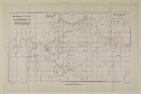
- Title
- ‘12. Organisation of Communications in Summer & Autumn 1916’
- Pages
- 23r:23v
- Author
- East India Company, the Board of Control, the India Office, or other British Government Department
- Usage terms
- Open Government Licence
- Reference
- IOR/L/MIL/17/15/72/2, f 24
- Title
- ‘13. Shaikh Saad and Kut-Al-Amara. Situation 22nd December 1916’
- Pages
- 24r:24v
- Author
- East India Company, the Board of Control, the India Office, or other British Government Department
- Usage terms
- Open Government Licence
- Reference
- IOR/L/MIL/17/15/72/2, f 25
- Title
- ‘14. Shaikh Saad and Kut-Al-Amara. Situation 6 p.m. 1st February 1917’
- Pages
- 25r:25v
- Author
- East India Company, the Board of Control, the India Office, or other British Government Department
- Usage terms
- Open Government Licence