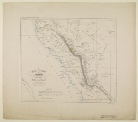
‘Skizze einer Karte von Asyr und einem Theile von Hedjas und Nedjd nach Chedufeaus Materialien, entworfen von den Capt. Ing. Galinier und Ferret’
IOR/X/2942/5/5
2 items in this record
Search within this record
The record is made up of 1 map sheet. It was created in 1846. It was written in German. The original is part of the British Library: Map Collections.
About this record
- Content
Distinctive Features:
Above map at top left: ‘Zum Atlas von Vorder-Asien gehörig, Heft V, Arabien’.
Relief shown by hachures.
Shows the approximate location of the major nomadic tribes across the region.
- Extent and format
- 1 map sheet
- Area map covers
- Map loading...
- Scale
- not given
- Scale designator
- Horizontal
- Orientation
- North
- Degree coordinates
- Top-left: 22° 0' 16.2" N, 38° 15' 5.04" E
Top-right: 22° 0' 16.2" N, 43° 0' 25.2" E
Bottom-left: 16° 53' 44.52" N, 38° 15' 5.04" E
Bottom-right: 16° 53' 44.52" N, 43° 0' 25.2" E - It is part of
- 10 imagesRef: IOR/X/2942/5
- Physical characteristics
Dimensions: 405 x 475 mm, on sheet 604 x 690 mm
- Written in
- German in Latin script
- Type
- Map
Archive information for this record
- Original held at
- British Library: Map Collections
- Access conditions
Unrestricted
- Archive reference
- IOR/X/2942/5/5
- Former external reference(s)
- O.XIX.17
- Date(s)
- 1846 (CE, Gregorian)
Access & Reference
History of this record
Related material
Related search terms
- Places
- ʻAsīr Region
- People & organisations
- Karl RitterHermann DeliusDietrich ReimerCarl Zimmermann
Use and share this record
- Share this record
- Cite this record in your research
‘Skizze einer Karte von Asyr und einem Theile von Hedjas und Nedjd nach Chedufeaus Materialien, entworfen von den Capt. Ing. Galinier und Ferret’, British Library: Map Collections, IOR/X/2942/5/5, in Qatar Digital Library <https://www.qdl.qa/archive/81055/vdc_100023867342.0x000001> [accessed 25 April 2024]
- Link to this record
https://www.qdl.qa/en/archive/81055/vdc_100023867342.0x000001
- IIIF details
This record has a IIIF manifest available as follows. If you have a compatible viewer you can drag the icon to load it.https://www.qdl.qa/en/iiif/81055/vdc_100000000926.0x0000dd/manifestOpen in Universal viewerOpen in Mirador viewerMore options for embedding images
Copyright: How to use this content
- Reference
- IOR/X/2942/5/5
- Title
- ‘Skizze einer Karte von Asyr und einem Theile von Hedjas und Nedjd nach Chedufeaus Materialien, entworfen von den Capt. Ing. Galinier und Ferret’
- Pages
- 5r:5v
- Author
- Please see item description
- Usage terms
- Public Domain