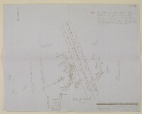
Sketch map of Arabia
Mss Eur F126/107, f 2
2 items in this record
Search within this record
The record is made up of 1 map. It was created in 1865. It was written in English. The original is part of the British Library: India Office The department of the British Government to which the Government of India reported between 1858 and 1947. The successor to the Court of Directors. Records and Private Papers Documents collected in a private capacity. .
About this record
- Content
Distinctive Features:
Hand drawn rough map signed by Sir Lewis Pelly showing his intended route from Koweit [Kuwait] via Riyath [Riyadh] to Bahrein [Bahrain] with notations concerning the terrain features and the approximate location of the settlements marked. Indicates the boundary between Nejd and Hejaz and the extent of Nafud or Dehna Desert and Hajaz Samaan stony tract. Includes details on the camel caravan journey with a scale showing 12 days journey of about 24 miles per day inserted at the bottom right-hand corner.
The verso The back of a sheet of paper or leaf, often abbreviated to 'v'. of the map contains a rough pencil sketch of the central part of the Arabian Peninsula with Reyath [Riyadh] located in the centre.
- Extent and format
- 1 map
- Area map covers
- Map loading...
- Scale
- Scale not given
- Scale designator
- Horizontal
- Orientation
- North
- Degree coordinates
- Top-left: 29° 38' 33.36" N, 38° 31' 32.52" E
Top-right: 29° 38' 33.36" N, 50° 50' 7.44" E
Bottom-left: 21° 6' 56.88" N, 38° 31' 32.52" E
Bottom-right: 21° 6' 56.88" N, 50° 50' 7.44" E - It is part of
- 8 imagesRef: Mss Eur F126/107
- Physical characteristics
Materials: Pen and ink on paper with additions in pencil and crayon
Dimensions: 398 x 504 mm
Watermark: The paper contains the watermark ‘T H Saunders, 1860'.
- Written in
- English in Latin script
- Type
- Map
Archive information for this record
- Original held at
- British Library: India Office The department of the British Government to which the Government of India reported between 1858 and 1947. The successor to the Court of Directors. Records and Private Papers Documents collected in a private capacity.
- Access conditions
Unrestricted
- Archive reference
- Mss Eur F126/107, f 2
- Date(s)
- 1865 (CE, Gregorian)
Access & Reference
History of this record
Use and share this record
- Share this record
- Cite this record in your research
Sketch map of Arabia, British Library: India Office Records and Private Papers, Mss Eur F126/107, f 2, in Qatar Digital Library <https://www.qdl.qa/archive/81055/vdc_100024376729.0x000001> [accessed 18 April 2024]
- Link to this record
https://www.qdl.qa/en/archive/81055/vdc_100024376729.0x000001
- IIIF details
This record has a IIIF manifest available as follows. If you have a compatible viewer you can drag the icon to load it.https://www.qdl.qa/en/iiif/81055/vdc_100000001524.0x0003de/manifestOpen in Universal viewerOpen in Mirador viewerMore options for embedding images
Copyright: How to use this content
- Reference
- Mss Eur F126/107, f 2
- Title
- Sketch map of Arabia
- Pages
- 2r:2v
- Author
- East India Company, the Board of Control, the India Office, or other British Government Department
- Usage terms
- Open Government Licence