![‘Sketch of camp 1 mile south of MANAMAH (BAHRAIN ISLAND)’ [‎3r] (1/2)](https://iiif.qdl.qa/iiif/images/81055/vdc_100000000282.0x00022b/IOR_R_15_2_1820_0005.jp2/full/!1200,1200/0/default.jpg "‘Sketch of camp 1 mile south of MANAMAH (BAHRAIN ISLAND)’ [‎3r] (1/2)")
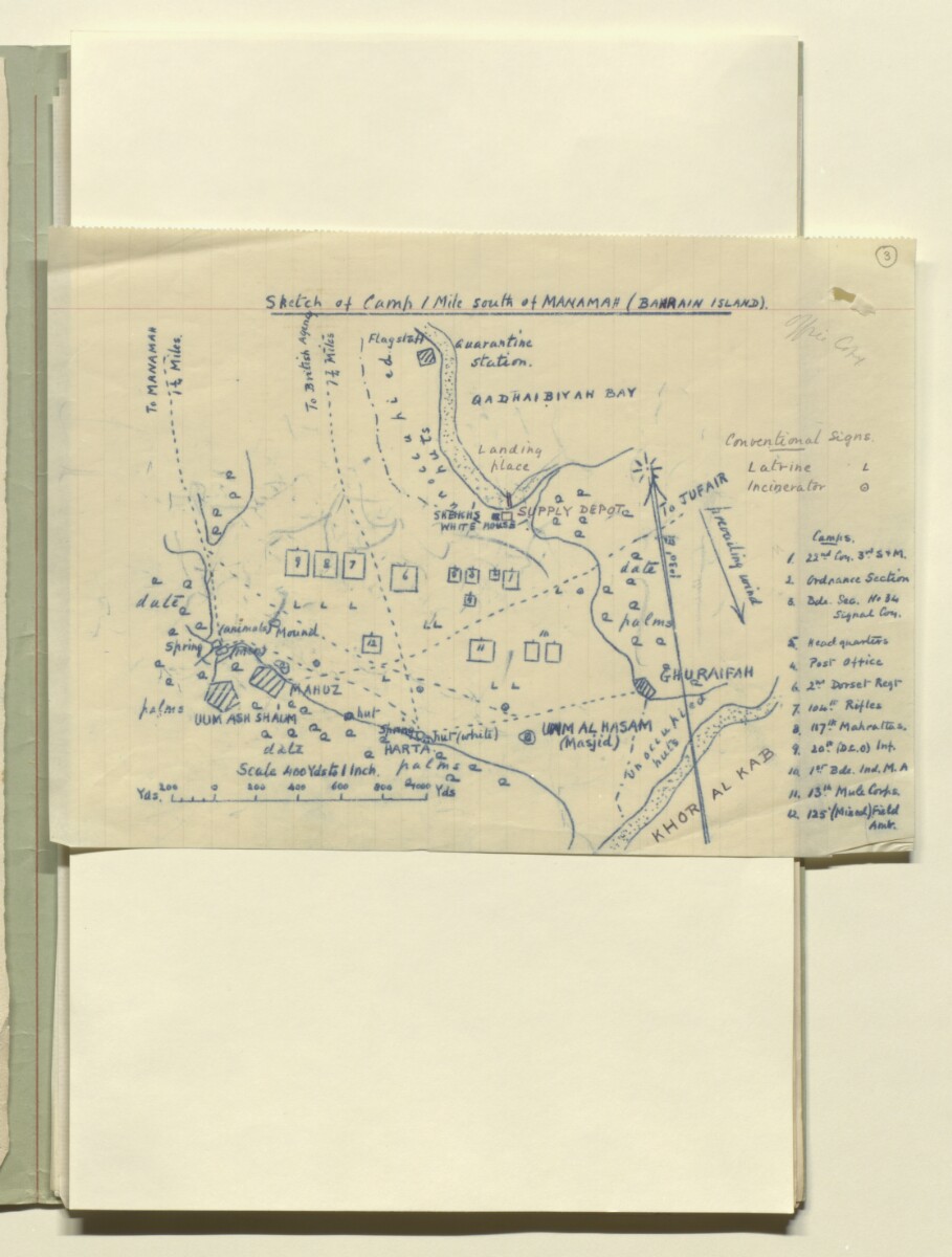
‘Sketch of camp 1 mile south of MANAMAH (BAHRAIN ISLAND)’ [3r] (1/2)
The record is made up of 1 map. It was created in 1914. It was written in English. The original is part of the British Library: India Office The department of the British Government to which the Government of India reported between 1858 and 1947. The successor to the Court of Directors. Records and Private Papers Documents collected in a private capacity. .
About this item
- Content
The map is a hand drawn copy made through carbon paper, with some additional handwritten pencil annotations. It shows twelve camps (numbered 1-12), indicated as squares on the map, with a key identifying each camp (allocated to various regiments of Indian Expeditionary Force D) to the right of the map. Besides the camps, other features shown include: latrines, incinerators; human settlements (Uum Ash Shaum [Umm al Ḩaşşam], Mahuz [Al Māḩūz], Ghuraifah [Ghuraifa]); paths; date palm gardens; coastline; specific buildings and other landmarks (quarantine station, shaikh’s house, flagstaff, huts, suppy depot). The map also indicates the distance in miles to Manama and the British Political Agency An office of the East India Company and, later, of the British Raj, headed by an agent. .
- Extent and format
- 1 map
- Area map covers
- Map loading...
- Scale
- 1:14000
- Scale designator
- Horizontal
- Orientation
- North
- Degree coordinates
- Top-left: 26° 13' 15.26" N, 50° 34' 57.98" E
Top-right: 26° 13' 15.26" N, 50° 37' 7.44" E
Bottom-left: 26° 12' 2.07" N, 50° 34' 57.98" E
Bottom-right: 26° 12' 2.07" N, 50° 37' 7.44" E - Physical characteristics
Materials: Paper folio.
Dimensions: 182 x 256 mm.
Foliation: The map is foliated in the top right corner with a circled pencil number.
- Written in
- English in Latin script View the complete information for this record
Use and share this item
- Share this item
‘Sketch of camp 1 mile south of MANAMAH (BAHRAIN ISLAND)’ [3r] (1/2), British Library: India Office Records and Private Papers, IOR/R/15/2/1820, f 3, in Qatar Digital Library <https://www.qdl.qa/archive/81055/vdc_100026678670.0x000006> [accessed 19 April 2024]
https://www.qdl.qa/en/archive/81055/vdc_100026678670.0x000006
Copy and paste the code below into your web page where you would like to embed the image.
<meta charset="utf-8"><a href="https://www.qdl.qa/en/archive/81055/vdc_100026678670.0x000006">‘Sketch of camp 1 mile south of MANAMAH (BAHRAIN ISLAND)’ [‎3r] (1/2)</a> <a href="https://www.qdl.qa/en/archive/81055/vdc_100026678670.0x000006"> <img src="https://iiif.qdl.qa/iiif/images/81055/vdc_100000000282.0x00022b/IOR_R_15_2_1820_0005.jp2/full/!280,240/0/default.jpg" alt="" /> </a>
This record has a IIIF manifest available as follows. If you have a compatible viewer you can drag the icon to load it.https://www.qdl.qa/en/iiif/81055/vdc_100000000282.0x00022b/manifestOpen in Universal viewerOpen in Mirador viewerMore options for embedding images
Copyright: How to use this content
- Reference
- IOR/R/15/2/1820, f 3
- Title
- ‘Sketch of camp 1 mile south of MANAMAH (BAHRAIN ISLAND)’
- Pages
- 3r:3v
- Author
- East India Company, the Board of Control, the India Office, or other British Government Department
- Usage terms
- Open Government Licence