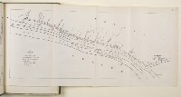
'III SKETCH MAP OF A PORTION OF THE TURCO-PERSIAN FRONTIER AT ITS JUCTION WITH THE SHATT-UL-ARAB RIVER (As delimited in 1913-14)'
IOR/L/PS/10/231, f 17

2 items in this record
Search within this record
The record is made up of 1 map. It was created in 1916. It was written in English. The original is part of the British Library: India Office The department of the British Government to which the Government of India reported between 1858 and 1947. The successor to the Court of Directors. Records and Private Papers Documents collected in a private capacity. .
About this record
- Content
The map shows the Shatt-ul-Arab [Shatt al-Arab] waterway with the frontier line between Turkey and Persia show in red ink.
- Extent and format
- 1 map
- It is part of
- 358 imagesRef: IOR/L/PS/10/231
- Physical characteristics
Materials: Printed on paper.
Dimensions: 330 x 200mm.
- Written in
- English in Latin script
- Type
- Map
Archive information for this record
- Original held at
- British Library: India Office The department of the British Government to which the Government of India reported between 1858 and 1947. The successor to the Court of Directors. Records and Private Papers Documents collected in a private capacity.
- Access conditions
Unrestricted
- Archive reference
- IOR/L/PS/10/231, f 17
- Former external reference(s)
- S.D.O. No. 1627, Sept. 1916
- Date(s)
- 1916 (CE, Gregorian)
Access & Reference
History of this record
Use and share this record
- Share this record
- Cite this record in your research
'III SKETCH MAP OF A PORTION OF THE TURCO-PERSIAN FRONTIER AT ITS JUCTION WITH THE SHATT-UL-ARAB RIVER (As delimited in 1913-14)', British Library: India Office Records and Private Papers, IOR/L/PS/10/231, f 17, in Qatar Digital Library <https://www.qdl.qa/archive/81055/vdc_100031794572.0x000003> [accessed 25 April 2024]
- Link to this record
https://www.qdl.qa/en/archive/81055/vdc_100031794572.0x000003
- IIIF details
This record has a IIIF manifest available as follows. If you have a compatible viewer you can drag the icon to load it.https://www.qdl.qa/en/iiif/81055/vdc_100000000419.0x00007c/manifestOpen in Universal viewerOpen in Mirador viewerMore options for embedding images
Copyright: How to use this content
- Reference
- IOR/L/PS/10/231, f 17
- Title
- 'III SKETCH MAP OF A PORTION OF THE TURCO-PERSIAN FRONTIER AT ITS JUCTION WITH THE SHATT-UL-ARAB RIVER (As delimited in 1913-14)'
- Pages
- 17r:17v
- Author
- East India Company, the Board of Control, the India Office, or other British Government Department
- Usage terms
- Open Government Licence