Map of the Arabian Coast, Red Sea, and Persian Gulf
12896
1 items in this record
The record is made up of 1 items. It was created in 1745/1746. It was written in French. The original is part of the Qatar National Library.
About this record
- Content
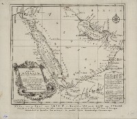
This map of the coastlines of the Arabian Peninsula and adjacent regions is by the French hydrographer and cartographer Jacques-Nicolas Bellin (1703−72). Bellin was attached to the French Marine Office for more than 50 years and specialized in producing maritime maps. He also made most of the maps for Histoire générale des voyages: ou, Nouvelle collection de toutes les relations de voyages par mer et par terre, qui ont été publiées jusqu'à présent dans les différentes langues de toutes les nations connues (General history of the voyages, or, a new collection of all the accounts of voyages on sea and on land, which have been published up to the present in the different languages of all known countries), a 15-volume compendium edited by Abbé Antoine-François Prévost (1697–1763) and published between 1746 and 1759. This map appeared in the first volume of this work. The map shows coastlines, ports, and coastal shoals. At a time when the determination of location was still an inexact science, a note at upper right explains the use of three different symbols on the map: a star to indicate places where location had been determined by astronomical observations of latitude and longitude; a cross to indicate places where location had been determined by astronomical observations of (only) latitude; and a modified cross to indicate places where location had been determined by latitudinal observations made by skilled navigators.
- Extent and format
- 1 items
- Physical characteristics
1 map ; 22 x 25 centimeters
- Written in
- French in Latin script
- Type
- Map
Archive information for this record
- Original held at
- Qatar National Library
- Access conditions
Unrestricted
- Archive reference
- 12896
- Date(s)
- 1745/1746 (CE, Gregorian)
Access & Reference
History of this record
Related search terms
Use and share this record
- Share this record
- Cite this record in your research
Map of the Arabian Coast, Red Sea, and Persian Gulf, Qatar National Library, 12896, in Qatar Digital Library <https://www.qdl.qa/archive/qnlhc/12896> [accessed 18 April 2024]
- Link to this record
https://www.qdl.qa/en/archive/qnlhc/12896
- IIIF details
This record has a IIIF manifest available as follows. If you have a compatible viewer you can drag the icon to load it.https://www.qdl.qa/en/iiif/qnlhc/12896/manifestOpen in Universal viewerOpen in Mirador viewerMore options for embedding images
Copyright: How to use this content
- Reference
- 12896
- Title
- Map of the Arabian Coast, Red Sea, and Persian Gulf
- Pages
- F-1-1 - F-1-1
- Author
- Qatar National Library
- Usage terms
- Public Domain