Map of the Coast of Arabia, the Red Sea and the Persian Gulf
2918
1 items in this record
The record is made up of 1 items. It was created in 1740. It was written in French. The original is part of the Qatar National Library.
About this record
- Content
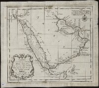
This 1740 map is by the French cartographer and hydrographer Jacques-Nicolas Bellin (1703-72). It was published by order of Jean-Frédéric Phélypeaux, Count de Maurepas (1701-81), secretary of state under King Louis XV. The map focuses exclusively on the coastlines, and provides no detail about the interior of the Arabian Peninsula. It shows pearl banks along the coast from Bahrain to Julfar. Qatar is noted (“Katara”), but the peninsula that it occupies is not accurately drawn. Kuwait is not shown, but the island of “Peleche” is indicated. The Red Sea is indicated as Mer Rouge ou Golfe d’Arabie (the Red Sea or the Gulf of Arabia). The note at upper right explains the use of three different symbols: a star to indicate places whose locations had been determined by astronomical observations of latitude and longitude; a cross to indicate places whose locations had been determined by astronomical observations of (only) latitude; and a modified cross to indicate places whose locations had been determined by latitudinal observations made by skilled navigators.
- Extent and format
- 1 items
- Physical characteristics
1 map; black and white; 20.50 x 23.50 centimeters
- Written in
- French in Latin script
- Type
- Map
Archive information for this record
- Original held at
- Qatar National Library
- Access conditions
Unrestricted
- Archive reference
- 2918
- Date(s)
- 1740 (CE, Gregorian)
Access & Reference
History of this record
Related search terms
Use and share this record
- Share this record
- Cite this record in your research
Map of the Coast of Arabia, the Red Sea and the Persian Gulf, Qatar National Library, 2918, in Qatar Digital Library <https://www.qdl.qa/archive/qnlhc/2918> [accessed 18 April 2024]
- Link to this record
https://www.qdl.qa/en/archive/qnlhc/2918
- IIIF details
This record has a IIIF manifest available as follows. If you have a compatible viewer you can drag the icon to load it.https://www.qdl.qa/en/iiif/qnlhc/2918/manifestOpen in Universal viewerOpen in Mirador viewerMore options for embedding images
Copyright: How to use this content
- Reference
- 2918
- Title
- Map of the Coast of Arabia, the Red Sea and the Persian Gulf
- Pages
- F-1-1 - F-1-1
- Author
- Qatar National Library
- Usage terms
- Public Domain