!['ROUTES IN PERSIA. SECTION III' [‎176v] (357/739)](https://iiif.qdl.qa/iiif/images/81055/vdc_100000001491.0x000114/Mss Eur F111_371_0355.jp2/full/!1200,1200/0/default.jpg "'ROUTES IN PERSIA. SECTION III' [‎176v] (357/739)")
'ROUTES IN PERSIA. SECTION III' [176v] (357/739)
The record is made up of 1 volume (367 folios). It was created in 1898. It was written in English. The original is part of the British Library: India Office The department of the British Government to which the Government of India reported between 1858 and 1947. The successor to the Court of Directors. Records and Private Papers Documents collected in a private capacity. .
Transcription
This transcription is created automatically. It may contain errors.
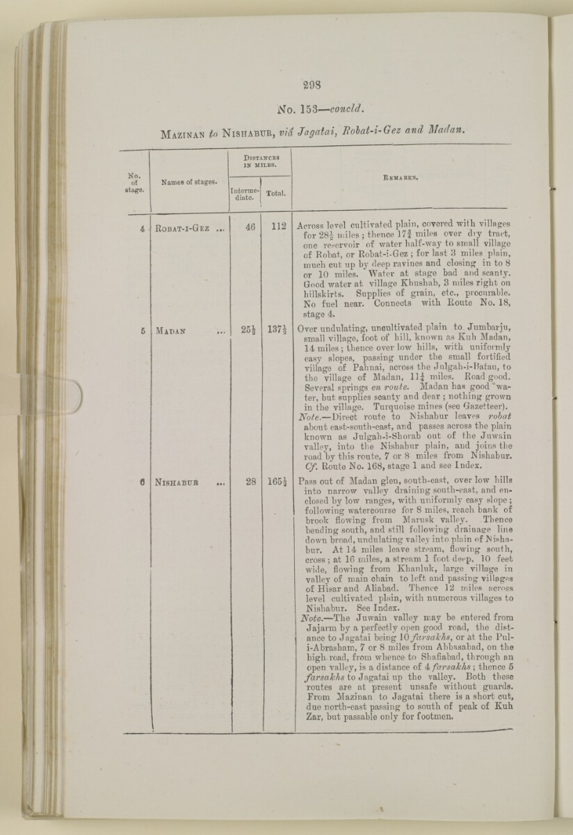
298
No. 153— concld.
M azinan to N ishabur, via Jagatai, Rohat -i-Gez and Madan.
No.
of
stage.
D istances
in miles.
E emaeks.
Names of stages.
Interme
diate.
Total.
4
K obat-i -G ez ...
46
112
Across level cultivated plain, covered witli villages
for 28i miles ; thence 17i miles over dry tract,
one reservoir of water half-way to small village
of Rohat, or Robat-i-Gez ; for last 3 miles^ plain,
much cut up by deep ravines and closing in to 8
or 10 miles. Water at stage bad and scanty.
Good water at village Khushab, 3 miles right on
hillskirts. Supplies of grain, etc., procurable.
No fuel near. Connects with Eoute No. 18,
stage 4.
Over undulating, uncultivated plain to Jumbarju,
small village, foot of hill, known as Kuh Madan,
14 miles ; thence over low hills, with uniformly
easy slopes, passing under the small fortified
village of Pahnai, across the Julgah-i-Batau, to
the village of Madan, Hi miles. Road good.
Several springs en route. Madan has good ''wa
ter, but supplies scanty and dear ; nothing grown
in the village. Turquoise mines (see Gazetteer).
iVoife.—Direct route to INishabur leaves rohat
about east-south-east, and passes across the plain
known as Julgah-i-Shorab out of the Juwain
valley, into the Nishabur plain, and joins the
road by this route, 7 or 8 miles from Nishabur.
Cf. Route No. 168, stage 1 and see Index.
5
M adak
25i
137|
6
N ishabur
28
165J
Pass out of Madan glen, south-east, over low hills
into narrow valley draining south-east, and en
closed by low ranges, with uniformly easy slope;
following watercourse for 8 miles, reach bank of
brook flowing from Marusk valley. Thence
bending south, and still following drainage line
down broad, undulating valley into plain of Nisha
bur. At 14 miles leave stream, flowing south,
cross ; at 16 miles, a stream 1 foot deep, 10 feet
wide, flowing from Khanluk, large village in
valley of main chain to left and passing villages
of Hisar and Aliabad. Thence 12 miles across
level cultivated plain, with numerous villages to
Nishab\n\ See Index.
"Note. —The Juwain valley may be entered from
Jajarm by a perfectly open good road, the dist
ance to Jagatai being 10 farsakhs, or at the Pul-
i-Abrasham, 7 or 8 miles from Abbasabad, on the
high-road, from whence to Shafiabad, through an
open valley, is a distance of 4 farsalchs ; thence 5
to Jagatai up the valley. Both these
routes are at present unsafe without guards.
From Mazinan to Jagatai there is a short cut,
due north-east passing to south of peak of Kuh
Zar, but passable only for footmen.
About this item
- Content
The volume is a Government of India official publication entitled Routes in Persia. Section III. Compiled in the Intelligence Branch of the Quarter Master General's Department in India (Simla: printed at the Government Central Printing Office, 1898).
The volume contains details of all land routes (numbered 1-247) in Persia starting from Russian territory and extending south as far as a line drawn from Karmanshah [Kermānshāh] south-eastwards through Burujird [Borūjerd], Isfahan [Eşfahān] and Yazd to Karman [Kermān], and thence north-east to Khabis [Khabīş] and Neh to Lash Juwain [Lāsh-e Juwayn].
The information given for each route comprises:
- number of route;
- place names forming starting point and destination of route;
- authority and date;
- number of stage;
- names of stages;
- distance in miles (intermediate and total);
- remarks (including precise details of the route, general geographical information, and information on smaller settlements, local peoples, agriculture, condition of roads, access to water, supplies of wood, and other routes).
An appendix within the volume (folios 356-359) and two separately-stored sets of loose sheets (containing routes numbers 77 (a) and 140-A, folios 363-369) give information too late for incorporation in the body of the work.
The volume also contains pockets attached to the front and back inside covers for maps. These consist of an index map showing the limits of each of the three sections of Routes in Persia (folio 2) and an index map to the routes in Section III (folio 361). There is also a fold-out map of the route from Seistan [Sīstān] to Mashad on folio 232.
An ink stamp on the front cover records the confidential nature of the publication and that it was being transmitted for the information of His Excellency the Viceroy (Victor Alexander Bruce, 9th Earl of Elgin and 16th Earl of Kincardine) only.
- Extent and format
- 1 volume (367 folios)
- Arrangement
The volume contains an alphabetical cross index (folios 6-17), and an alphabetical index to names of places (folios 18-25).
- Physical characteristics
Foliation: the foliation sequence commences at the front cover and terminates on the last page of the loose supplementary sheets (found in the small grey folder within the main folder); these numbers are written in pencil, are circled, and are located in the top right corner of the recto The front of a sheet of paper or leaf, often abbreviated to 'r'. side of each folio.
Pagination: the volume also contains a printed pagination sequence.
- Written in
- English in Latin script View the complete information for this record
Use and share this item
- Share this item
'ROUTES IN PERSIA. SECTION III' [176v] (357/739), British Library: India Office Records and Private Papers, Mss Eur F111/371, in Qatar Digital Library <https://www.qdl.qa/archive/81055/vdc_100024054421.0x00009c> [accessed 16 April 2024]
https://www.qdl.qa/en/archive/81055/vdc_100024054421.0x00009c
Copy and paste the code below into your web page where you would like to embed the image.
<meta charset="utf-8"><a href="https://www.qdl.qa/en/archive/81055/vdc_100024054421.0x00009c">'ROUTES IN PERSIA. SECTION III' [‎176v] (357/739)</a> <a href="https://www.qdl.qa/en/archive/81055/vdc_100024054421.0x00009c"> <img src="https://iiif.qdl.qa/iiif/images/81055/vdc_100000001491.0x000114/Mss Eur F111_371_0355.jp2/full/!280,240/0/default.jpg" alt="" /> </a>
This record has a IIIF manifest available as follows. If you have a compatible viewer you can drag the icon to load it.https://www.qdl.qa/en/iiif/81055/vdc_100000001491.0x000114/manifestOpen in Universal viewerOpen in Mirador viewerMore options for embedding images
Copyright: How to use this content
- Reference
- Mss Eur F111/371
- Title
- 'ROUTES IN PERSIA. SECTION III'
- Pages
- front, back, spine, edge, head, tail, front-i, 2r:58r, 59r:232r, 232r:233r, 234r:361v, back-i, 363r:363v, 365r:369v
- Author
- East India Company, the Board of Control, the India Office, or other British Government Department
- Usage terms
- Open Government Licence