!['SKETCH MAP OF QATAR PENINSULA' [‎23v] (2/2)](https://iiif.qdl.qa/iiif/images/81055/vdc_100000000241.0x00022f/IOR_R_15_2_416_0063.jp2/full/!1200,1200/0/default.jpg "'SKETCH MAP OF QATAR PENINSULA' [‎23v] (2/2)")
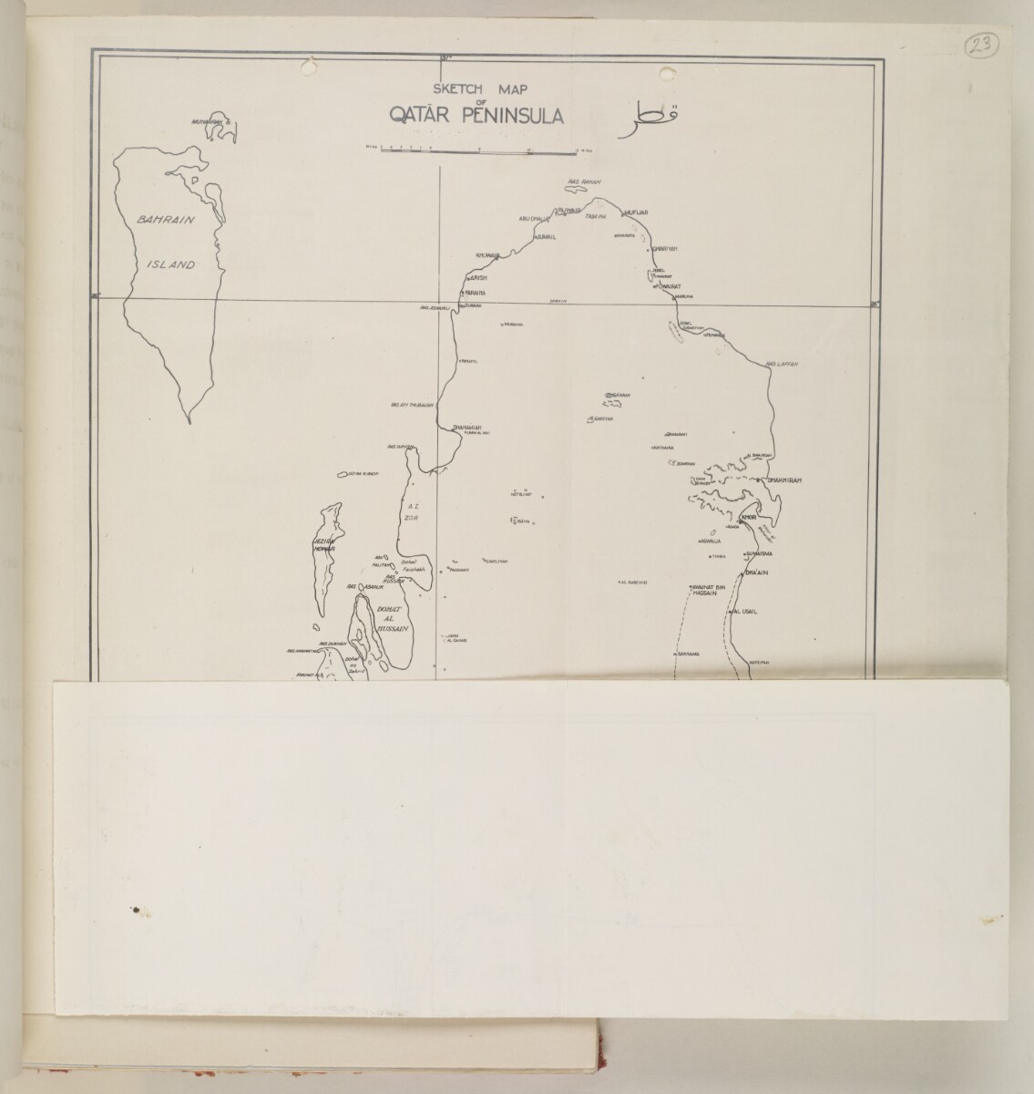
'SKETCH MAP OF QATAR PENINSULA' [23v] (2/2)
The record is made up of 1 map sheet. It was created in 1935?. It was written in English and Arabic. The original is part of the British Library: India Office The department of the British Government to which the Government of India reported between 1858 and 1947. The successor to the Court of Directors. Records and Private Papers Documents collected in a private capacity. .
About this item
- Content
Distinctive Features:
Relief shown by hachures.
Roads indicated by pecked lines. Shows Qatar and Bahrain.
The Southern border of Qatar is indicated by a thick pecked line.
Copy of the map enclosed to a letter on the question of the Southern limit of the Qatar Oil Concession sent by L. Lefroy at the Britannic House, London, to J.G. Laithwhite at the India Office The department of the British Government to which the Government of India reported between 1858 and 1947. The successor to the Court of Directors. , London, on 18 January 1935 (IOR/R/15/416, folio 4).
Inscriptions:
Toponyms are in English; Qatar and Dohah are also translated to Arabic.
- Extent and format
- 1 map sheet
- Area map covers
- Map loading...
- Scale
- 1: 804,000
- Scale designator
- Horizontal
- Orientation
- North
- Degree coordinates
- Top-left: 26° 22' 48" N, 50° 22' 12" E
Top-right: 26° 22' 48" N, 51° 43' 12" E
Bottom-left: 24° 10' 12" N, 50° 22' 12" E
Bottom-right: 24° 10' 12" N, 51° 43' 12" E - Physical characteristics
Materials: printed on paper
Dimensions: 402 x 250 mm; on sheet 415 x 299 mm.
Foliation: The map has been foliated in the top right hand corner with a pencil number enclosed in a circle.
- Written in
- English and Arabic in Latin and Arabic script View the complete information for this record
Use and share this item
- Share this item
'SKETCH MAP OF QATAR PENINSULA' [23v] (2/2), British Library: India Office Records and Private Papers, IOR/R/15/2/416, f 23, in Qatar Digital Library <https://www.qdl.qa/archive/81055/vdc_100024084949.0x00003e> [accessed 18 April 2024]
https://www.qdl.qa/en/archive/81055/vdc_100024084949.0x00003e
Copy and paste the code below into your web page where you would like to embed the image.
<meta charset="utf-8"><a href="https://www.qdl.qa/en/archive/81055/vdc_100024084949.0x00003e">'SKETCH MAP OF QATAR PENINSULA' [‎23v] (2/2)</a> <a href="https://www.qdl.qa/en/archive/81055/vdc_100024084949.0x00003e"> <img src="https://iiif.qdl.qa/iiif/images/81055/vdc_100000000241.0x00022f/IOR_R_15_2_416_0063.jp2/full/!280,240/0/default.jpg" alt="" /> </a>
This record has a IIIF manifest available as follows. If you have a compatible viewer you can drag the icon to load it.https://www.qdl.qa/en/iiif/81055/vdc_100000000241.0x00022f/manifestOpen in Universal viewerOpen in Mirador viewerMore options for embedding images
Copyright: How to use this content
- Reference
- IOR/R/15/2/416, f 23
- Title
- 'SKETCH MAP OF QATAR PENINSULA'
- Pages
- 23r:23v
- Author
- Anglo-Iranian Oil Company Limited (xx Anglo-Persian)
- Copyright
- ©BP is believed to be the rightsholder
- Usage terms
- Creative Commons Non-Commercial Licence