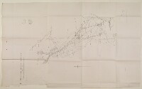
'Map of the Proposed Railway from Aden to Nobat Dakim'
IOR/L/PS/10/89, f 114

2 items in this record
Search within this record
The record is made up of 1 map. It was created in Jan 1906. It was written in English. The original is part of the British Library: India Office The department of the British Government to which the Government of India reported between 1858 and 1947. The successor to the Court of Directors. Records and Private Papers Documents collected in a private capacity. .
About this record
- Content
The map shows the path for a proposed railway to be built from Aden to Nobat Dakim [Nawbatal-Dakim, Yemen; identified four miles north of Al'Anad but not corresponding to any place]. The map was zincographed by the Vandyke Process at the Survey of India Offices, in Calcutta.
- Extent and format
- 1 map
- Area map covers
- Map loading...
- Scale
- 1 inch: 2 miles
- Scale designator
- Horizontal
- Degree coordinates
- Top-left: 13° 28' 11.15" N, 44° 40' 33.25" E
Top-right: 13° 28' 11.15" N, 45° 11' 22.25" E
Bottom-left: 12° 41' 57.45" N, 44° 40' 33.25" E
Bottom-right: 12° 41' 57.45" N, 45° 11' 22.25" E - It is part of
- 308 imagesRef: IOR/L/PS/10/89
- Physical characteristics
Materials: 1 paper folio
Condition: the map, originally housed in a paper sleeve on folio 113, is now enclosed in a polyester sleeve.
- Written in
- English in Latin script
- Type
- Map
Archive information for this record
- Original held at
- British Library: India Office The department of the British Government to which the Government of India reported between 1858 and 1947. The successor to the Court of Directors. Records and Private Papers Documents collected in a private capacity.
- Access conditions
Unrestricted
- Archive reference
- IOR/L/PS/10/89, f 114
- Date(s)
- Jan 1906 (CE, Gregorian)
Access & Reference
History of this record
Use and share this record
- Share this record
- Cite this record in your research
'Map of the Proposed Railway from Aden to Nobat Dakim', British Library: India Office Records and Private Papers, IOR/L/PS/10/89, f 114, in Qatar Digital Library <https://www.qdl.qa/archive/81055/vdc_100026192896.0x000001> [accessed 17 April 2024]
- Link to this record
https://www.qdl.qa/en/archive/81055/vdc_100026192896.0x000001
- IIIF details
This record has a IIIF manifest available as follows. If you have a compatible viewer you can drag the icon to load it.https://www.qdl.qa/en/iiif/81055/vdc_100000000365.0x0003ae/manifestOpen in Universal viewerOpen in Mirador viewerMore options for embedding images
Copyright: How to use this content
- Reference
- IOR/L/PS/10/89, f 114
- Title
- 'Map of the Proposed Railway from Aden to Nobat Dakim'
- Pages
- 114r:114v
- Author
- East India Company, the Board of Control, the India Office, or other British Government Department
- Usage terms
- Open Government Licence