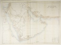
'MAP OF ARABIA AND THE PERSIAN GULF'
IOR/L/PS/10/60 (x)
2 items in this record
Search within this record
The record is made up of 1 map. It was created in 1908. It was written in English. The original is part of the British Library: India Office The department of the British Government to which the Government of India reported between 1858 and 1947. The successor to the Court of Directors. Records and Private Papers Documents collected in a private capacity. .
About this record
- Content
The map depicts the Arabian Peninsula and the Persian Gulf The historical term used to describe the body of water between the Arabian Peninsula and Iran. . The map indicates hydrology, boundaries, vegetation, roads and settlements as well as indication of relief given by form lines and hachures. A table of reference explains the type used on the map and the symbols and abbreviations.
A note under the title reads 'Compiled by Captain F.F. Hunter [Frederick Fraser Hunter], I.A. Survey of India'. Notes state that the map was transliterated by J G Lorimer [John Gordon Lorimer], outline and hill shading by Munshi A term used in the Middle East, Persia and South Asia to refer to a secretary, assistant or amanuensis. Munshis were employed in the British administration in the Gulf. Karim Bakhsh, published under the direction of the Surveyor General of India, Colonel F B Longe, and heliozincographed at the Survey of India Offices, Calcutta.
- Extent and format
- 1 map
- Area map covers
- Map loading...
- Orientation
- North
- Degree coordinates
- Top-left: 33° 17' 60" N, 31° 56' 60" E
Top-right: 33° 17' 60" N, 64° 15' 0" E
Bottom-left: 11° 48' 0" N, 31° 56' 60" E
Bottom-right: 11° 48' 0" N, 64° 15' 0" E - It is part of
- 536 imagesRef: IOR/L/PS/10/60
- Physical characteristics
Dimensions: 840 x 1180 mm, on a sheet 890 x 1230 mm
Materials: Printed in colour on paper
- Written in
- English in Latin script
- Type
- Map
Archive information for this record
- Original held at
- British Library: India Office The department of the British Government to which the Government of India reported between 1858 and 1947. The successor to the Court of Directors. Records and Private Papers Documents collected in a private capacity.
- Access conditions
Unrestricted
- Archive reference
- IOR/L/PS/10/60 (x)
- Former external reference(s)
- Reg No. 1770 D., 09 S.H. 800
- Date(s)
- 1908 (CE, Gregorian)
Access & Reference
History of this record
Use and share this record
- Share this record
- Cite this record in your research
'MAP OF ARABIA AND THE PERSIAN GULF', British Library: India Office Records and Private Papers, IOR/L/PS/10/60 (x), in Qatar Digital Library <https://www.qdl.qa/archive/81055/vdc_100048656965.0x000008> [accessed 24 April 2024]
- Link to this record
https://www.qdl.qa/en/archive/81055/vdc_100048656965.0x000008
- IIIF details
This record has a IIIF manifest available as follows. If you have a compatible viewer you can drag the icon to load it.https://www.qdl.qa/en/iiif/81055/vdc_100000000365.0x000391/manifestOpen in Universal viewerOpen in Mirador viewerMore options for embedding images
Copyright: How to use this content
- Reference
- IOR/L/PS/10/60 (x)
- Title
- 'MAP OF ARABIA AND THE PERSIAN GULF'
- Pages
- 238ar:238av
- Author
- East India Company, the Board of Control, the India Office, or other British Government Department
- Usage terms
- Open Government Licence