Map of the Turkish Empire
14673

2 items in this record
The record is made up of 2 items. It was created in 1600/1625. It was written in Latin. The original is part of the Qatar National Library.
About this record
- Content
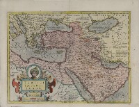
This map shows the Ottoman Empire as it appeared in the early 17th century. It details Ottoman territories in Asia, Africa, and Europe, and includes Persia, Transcaucasia, Ethiopia, and other surrounding lands. Topographic features, place-names, and populations are definitively marked, although the nomenclature of the time differs markedly from that used today. The Red Sea is termed the Sea of Mecca, for example, and the Persian Gulf The historical term used to describe the body of water between the Arabian Peninsula and Iran. is called the Sea of Alcatif. The map sometimes has been identified as a part of Atlas sive Cosmographicae Meditationes de Fabrica Mundi et Fabricati figura (Atlas of the world: finely engraved and drawn), produced by Jodocus Hondius following the work of Gerard Mercator. There is no evidence on the map itself to sustain that identification, nor is a date of publication supplied. Ottoman lands are hand-colored in red, except for the European territories. The vivid coloring is not contemporary with the production of the map and was probably added in the 19th century after Greece and the Balkan lands, which are not colored, were freed from Ottoman rule. Different lettering denotes different geographic and ethnographic features. Italics are generously used, and geometric shapes and shading are used to indicate mountain ranges and maritime littorals. The title cartouche indicates that Hondius, the supposed creator, based his map on Mercator’s projection. The cartouche itself is of interest for its cameo portrait entitled “Sultan Mahumet Turcorum Imperat” (Sultan Muhammad Emperor of the Turks), probably meant to represent Sultan Mehmed II (1432−81), known as Mehmed the Conqueror.
- Extent and format
- 2 items
- Physical characteristics
1 map : hand colored ; 34 x 47 centimeters
- Written in
- Latin in Latin script
- Type
- Map
Archive information for this record
- Original held at
- Qatar National Library
- Access conditions
Unrestricted
- Archive reference
- 14673
- Date(s)
- 1600/1625 (CE, Gregorian)
Access & Reference
History of this record
Related search terms
- Subjects
- Arabian PeninsulaArabian GulfBalkan PeninsulaMehmed II Sultan of the Turks Ottoman EmpirePersian Gulf
- Places
- AzerbaijanItalyLebanonIraqBulgariaCroatiaTurkeyRomaniaUnited Arab EmiratesYemenMoldovaSerbiaSaudi ArabiaUkraineQatarEgyptHungarySudanAmsterdamRussian FederationKuwaitMontenegroJordanIsraelGreeceArmeniaBahrainSloveniaIslamic Republic of IranGeorgiaSyrian Arab RepublicAlbaniaOmanFormer Yugoslav Republic of Macedonia
- People & organisations
- Gerhard MercatorJodocus Hondius
Use and share this record
- Share this record
- Cite this record in your research
Map of the Turkish Empire, Qatar National Library, 14673, in Qatar Digital Library <https://www.qdl.qa/archive/qnlhc/14673> [accessed 18 April 2024]
- Link to this record
https://www.qdl.qa/en/archive/qnlhc/14673
- IIIF details
This record has a IIIF manifest available as follows. If you have a compatible viewer you can drag the icon to load it.https://www.qdl.qa/en/iiif/qnlhc/14673/manifestOpen in Universal viewerOpen in Mirador viewerMore options for embedding images
Copyright: How to use this content
- Reference
- 14673
- Title
- Map of the Turkish Empire
- Pages
- F-1-1 - F-1-2
- Author
- Qatar National Library
- Usage terms
- Public Domain