Map of Ancient Arabia
2923
1 items in this record
The record is made up of 1 items. It was created in 1720. It was written in Latin. The original is part of the Qatar National Library.
About this record
- Content
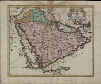
This map of the Arabian Peninsula, published in 1720, shows Arabia Felix, Arabia Deserta, and Arabia Petraea. Other regions included are Palestine, Mesopotamia, Chaldea, Persia, Aegyptus, and Aethiopia. A large number of towns are shown. The title cartouche includes nine vignette coins. The tribal and town names on the map are those used by Ptolemy. Some are used more than once, with variations. Thus “Indicara,” “Iacara,” “Ichara,” and “Aphana” all could indicate the same place: the spot where Alexander the Great intended to build a capital on an island in the Arabian Gulf, enabling him to control the trade of the region and extend his empire (a scheme that he was unable to accomplish before he died). Archeological research suggests that this place was Failakah Island in present-day Kuwait, although some historians place it at Abu Ali Island. The map shows a peninsula near present-day Bahrain. The islands of “Arathos” and “Thylaso” indicate Muharraq and Bahrain islands, respectively, which are actually located north of Qatar. On this map, they are placed on the Persian coast side, probably because the cartographer confused them with “Hormuz” and “Qishm.” Qatar is mentioned on the map as “Catara,” but its shape and location are not accurate. The map is by Christoph Weigel, a German engraver, art dealer, and publisher.
- Extent and format
- 1 items
- Physical characteristics
1 map; color; 35.90 x 29.30 centimeters
- Written in
- Latin in Latin script
- Type
- Map
Archive information for this record
- Original held at
- Qatar National Library
- Access conditions
Unrestricted
- Archive reference
- 2923
- Date(s)
- 1720 (CE, Gregorian)
Access & Reference
History of this record
Related search terms
- Subjects
- Persian GulfArabian PeninsulaArabian Gulf
- Places
- IraqNurembergSaudi ArabiaOmanKuwaitBahrainQatarYemenUnited Arab Emirates
- People & organisations
- Christoph Weigel
Use and share this record
- Share this record
- Cite this record in your research
Map of Ancient Arabia, Qatar National Library, 2923, in Qatar Digital Library <https://www.qdl.qa/archive/qnlhc/2923> [accessed 19 April 2024]
- Link to this record
https://www.qdl.qa/en/archive/qnlhc/2923
- IIIF details
This record has a IIIF manifest available as follows. If you have a compatible viewer you can drag the icon to load it.https://www.qdl.qa/en/iiif/qnlhc/2923/manifestOpen in Universal viewerOpen in Mirador viewerMore options for embedding images
Copyright: How to use this content
- Reference
- 2923
- Title
- Map of Ancient Arabia
- Pages
- F-1-1 - F-1-1
- Author
- Qatar National Library
- Usage terms
- Public Domain