File 3154/1912 Pt 1-2 ‘Turco-Persian frontier: the position of Hawizeh; miscellaneous prints’
IOR/L/PS/10/291


652 items in this record
Search within this record
The record is made up of 1 volume (322 folios). It was created in 1912. It was written in English and French. The original is part of the British Library: India Office The department of the British Government to which the Government of India reported between 1858 and 1947. The successor to the Court of Directors. Records and Private Papers Documents collected in a private capacity. .
About this record
- Content
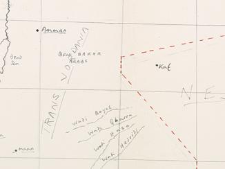
The volume contains parts 1 and 2 of the subject 'Turco-Persian Frontier'. Part 1 (IOR/L/10/PS/291/1 contains correspondence, reports and maps relating to surveys of the Turco-Persian frontier between Hawizeh [Hoveyzeh] and the Shatt-al-Arab, undertaken in May 1912 by the Political Resident A senior ranking political representative (equivalent to a Consul General) from the diplomatic corps of the Government of India or one of its subordinate provincial governments, in charge of a Political Residency. in the Persian Gulf The historical term used to describe the body of water between the Arabian Peninsula and Iran. , Lieutenant-Colonel Percy Zachariah Cox, and again in June and July 1912 by Lieutenant Arnold Talbot Wilson and Lieutenant Henry Aloysius Bruno Digby-Beste.
The surveys were carried out in order to fix the precise locations of the village of Hawizeh and the Turco-Persian border at Mohammerah [Khorramshahr]. The reports submitted by Cox and Wilson set out the topography of the region, its canals and rivers, populations, jurisdiction, tribal affiliations and tribal rulers. Digby-Beste’s report (ff 16-18) details the survey measurements taken between 15 June and 2 July 1912, with calculations of longitude and latitude measurements for Hawizeh.
Part 2 (IOR/L/PS/10/291/2 contains copies of correspondence, memoranda, maps and other papers, relating to diplomatic negotiations taking place between the Turkish and Persian Governments, marshalled by the British and Russian Governments, over the fixing of the boundary line between Persia and Turkish Mesopotamia at Mohammerah [Khorramshahr], Hawizeh [Hoveyzeh] and Zohab.
- Extent and format
- 1 volume (322 folios)
- It is grouped into
- 148 imagesRef: IOR/L/PS/10/291/1486 imagesRef: IOR/L/PS/10/291/2
- Arrangement
The papers are arranged in approximate chronological order from the rear to the front of the volume.
- Physical characteristics
Foliation: the main foliation sequence (used for referencing) commences at the front cover with 1, and terminates at the inside back cover with 324; these numbers are written in pencil, are circled, and are located in the top right corner of the recto The front of a sheet of paper or leaf, often abbreviated to 'r'. side of each folio.
A previous foliation sequence, which is also circled, has been superseded and therefore crossed out.
- Written in
- English and French in Latin script
- Type
- Archival file
Archive information for this record
- Original held at
- British Library: India Office The department of the British Government to which the Government of India reported between 1858 and 1947. The successor to the Court of Directors. Records and Private Papers Documents collected in a private capacity.
- Access conditions
Unrestricted
- Archive reference
- IOR/L/PS/10/291
- Former external reference(s)
- P 3154/1912 Pt 1 P 3154/1912 Pt 2
- Date(s)
- 1912 (CE, Gregorian)
Access & Reference
History of this record
Related search terms
- Subjects
- Boundaries
- Places
- MohammerahZohābHawizeh
- People & organisations
- Political Resident, Persian GulfBritish Consul, TabrizSir Arnold Talbot WilsonHenry Aloysius Bruno Digby-Beste
Use and share this record
- Share this record
- Cite this record in your research
File 3154/1912 Pt 1-2 ‘Turco-Persian frontier: the position of Hawizeh; miscellaneous prints’, British Library: India Office Records and Private Papers, IOR/L/PS/10/291, in Qatar Digital Library <https://www.qdl.qa/archive/81055/vdc_100000000419.0x0000b7> [accessed 23 April 2024]
- Link to this record
https://www.qdl.qa/en/archive/81055/vdc_100000000419.0x0000b7
- IIIF details
This record has a IIIF manifest available as follows. If you have a compatible viewer you can drag the icon to load it.https://www.qdl.qa/en/iiif/81055/vdc_100000000419.0x0000b7/manifestOpen in Universal viewerOpen in Mirador viewerMore options for embedding images
Copyright: How to use this content
- Reference
- IOR/L/PS/10/291/2
- Title
- File 3154/1912 Pt 2 ‘Turco-Persian Frontier: Miscellaneous Prints’
- Pages
- 300r:304v, 279v:280r, 243r
- Author
- Dervish Pasha
- Usage terms
- Public Domain
- Reference
- IOR/L/PS/10/291/2
- Title
- File 3154/1912 Pt 2 ‘Turco-Persian Frontier: Miscellaneous Prints’
- Pages
- 286r
- Author
- Unknown
- Usage terms
- The copyright status is unknown. Please contact copyright@bl.uk with any information you have regarding this item.
- Reference
- IOR/L/PS/10/291/2
- Title
- File 3154/1912 Pt 2 ‘Turco-Persian Frontier: Miscellaneous Prints’
- Pages
- 286v
- Author
- von Hammer-Purgstall, Joseph
- Usage terms
- Public Domain
- Reference
- IOR/L/PS/10/291/2
- Title
- File 3154/1912 Pt 2 ‘Turco-Persian Frontier: Miscellaneous Prints’
- Pages
- 287r
- Author
- Government of Persia
- Usage terms
- The copyright status is unknown. Please contact copyright@bl.uk with any information you have regarding this item.
- Reference
- IOR/L/PS/10/291/2
- Title
- File 3154/1912 Pt 2 ‘Turco-Persian Frontier: Miscellaneous Prints’
- Pages
- 287r, 88r
- Author
- Noradunkyan, Gabriel (Kapriel) Efendi
- Usage terms
- Public Domain
- Reference
- IOR/L/PS/10/291/2
- Title
- File 3154/1912 Pt 2 ‘Turco-Persian Frontier: Miscellaneous Prints’
- Pages
- 284r
- Author
- Russian Ambassador to London
- Usage terms
- The copyright status is unknown. Please contact copyright@bl.uk with any information you have regarding this item.
- Reference
- IOR/L/PS/10/291/2
- Title
- File 3154/1912 Pt 2 ‘Turco-Persian Frontier: Miscellaneous Prints’
- Pages
- 284r
- Author
- Benckendorff, Alexander Konstantinovich
- Usage terms
- The copyright status is unknown. Please contact copyright@bl.uk with any information you have regarding this item.
- Reference
- IOR/L/PS/10/291/2
- Title
- File 3154/1912 Pt 2 ‘Turco-Persian Frontier: Miscellaneous Prints’
- Pages
- 265r:266v, 232v:243r, 227r:228v, 168v:169r, 152v:153v
- Author
- Imperial Government of the Ottoman Empire
- Usage terms
- The copyright status is unknown. Please contact copyright@bl.uk with any information you have regarding this item.
- Reference
- IOR/L/PS/10/291/2
- Title
- File 3154/1912 Pt 2 ‘Turco-Persian Frontier: Miscellaneous Prints’
- Pages
- 265r:266v, 232v:243r, 227r:228v, 168v:169r, 152v:153v
- Author
- Government of Persia
- Usage terms
- The copyright status is unknown. Please contact copyright@bl.uk with any information you have regarding this item.
- Reference
- IOR/L/PS/10/291/2
- Title
- File 3154/1912 Pt 2 ‘Turco-Persian Frontier: Miscellaneous Prints’
- Pages
- 246v
- Author
- Sazonov, Sergei Dmitrievich
- Usage terms
- The copyright status is unknown. Please contact copyright@bl.uk with any information you have regarding this item.
- Reference
- IOR/L/PS/10/291/2
- Title
- File 3154/1912 Pt 2 ‘Turco-Persian Frontier: Miscellaneous Prints’
- Pages
- 247r
- Author
- Imperial Government of the Ottoman Empire
- Usage terms
- The copyright status is unknown. Please contact copyright@bl.uk with any information you have regarding this item.
- Reference
- IOR/L/PS/10/291/2
- Title
- File 3154/1912 Pt 2 ‘Turco-Persian Frontier: Miscellaneous Prints’
- Pages
- 244r, 132r:133v
- Author
- Government of Russia
- Usage terms
- The copyright status is unknown. Please contact copyright@bl.uk with any information you have regarding this item.
- Reference
- IOR/L/PS/10/291/2
- Title
- File 3154/1912 Pt 2 ‘Turco-Persian Frontier: Miscellaneous Prints’
- Pages
- 237r
- Author
- Unknown
- Usage terms
- The copyright status is unknown. Please contact copyright@bl.uk with any information you have regarding this item.
- Reference
- IOR/L/PS/10/291/2
- Title
- File 3154/1912 Pt 2 ‘Turco-Persian Frontier: Miscellaneous Prints’
- Pages
- 185r:185v
- Author
- Unknown
- Usage terms
- The copyright status is unknown. Please contact copyright@bl.uk with any information you have regarding this item.
- Reference
- IOR/L/PS/10/291/2
- Title
- File 3154/1912 Pt 2 ‘Turco-Persian Frontier: Miscellaneous Prints’
- Pages
- 172v:173r
- Author
- Zander, Kurt
- Usage terms
- The copyright status is unknown. Please contact copyright@bl.uk with any information you have regarding this item.
- Reference
- IOR/L/PS/10/291/2
- Title
- File 3154/1912 Pt 2 ‘Turco-Persian Frontier: Miscellaneous Prints’
- Pages
- 172v:173r
- Author
- Sakyz, Ohannes
- Usage terms
- The copyright status is unknown. Please contact copyright@bl.uk with any information you have regarding this item.
- Reference
- IOR/L/PS/10/291/2
- Title
- File 3154/1912 Pt 2 ‘Turco-Persian Frontier: Miscellaneous Prints’
- Pages
- 173r
- Author
- Baghdad Railway Company
- Usage terms
- The copyright status is unknown. Please contact copyright@bl.uk with any information you have regarding this item.
- Reference
- IOR/L/PS/10/291
- Title
- File 3154/1912 Pt 1-2 ‘Turco-Persian frontier: the position of Hawizeh; miscellaneous prints’
- Pages
- front, back, spine, edge, head, tail, front-i, 2r:3v, 78r:78v, 322r:323v, back-i
- Author
- East India Company, the Board of Control, the India Office, or other British Government Department
- Usage terms
- Open Government Licence
- Reference
- IOR/L/PS/10/291/1
- Title
- File 3154/1912 Pt 1 ‘Turco-Persian Frontier: the position of Hawizeh’
- Pages
- 4r:77v
- Author
- East India Company, the Board of Control, the India Office, or other British Government Department
- Usage terms
- Open Government Licence
- Reference
- IOR/L/PS/10/291/2
- Title
- File 3154/1912 Pt 2 ‘Turco-Persian Frontier: Miscellaneous Prints’
- Pages
- 79r:87v, 88v:131v, 134r:152r, 154r:168r, 169v:172r, 173v:184v, 186r:226v, 229r:232r, 243v, 244v:246r, 247v:264v, 267r:279r, 280v:283v, 284v:285v, 287v:299v, 305r:321v
- Author
- East India Company, the Board of Control, the India Office, or other British Government Department
- Usage terms
- Open Government Licence