Coll 28/28 ‘Persia. Perso-Baluchistan Frontier. Demarcation near Mirjawa.’
IOR/L/PS/12/3425

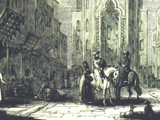
Coll 28/28 ‘Persia. Perso-Baluchistan Frontier. Demarcation near Mirjawa.’ [front] (1/658)View item

Coll 28/28 ‘Persia. Perso-Baluchistan Frontier. Demarcation near Mirjawa.’ [spine] (3/658)View item


Coll 28/28 ‘Persia. Perso-Baluchistan Frontier. Demarcation near Mirjawa.’ [ii-r] (10/658)View item

Coll 28/28 ‘Persia. Perso-Baluchistan Frontier. Demarcation near Mirjawa.’ [ii-v] (11/658)View item


Coll 28/28 ‘Persia. Perso-Baluchistan Frontier. Demarcation near Mirjawa.’ [45r] (100/658)View item

Coll 28/28 ‘Persia. Perso-Baluchistan Frontier. Demarcation near Mirjawa.’ [45v] (101/658)View item

Coll 28/28 ‘Persia. Perso-Baluchistan Frontier. Demarcation near Mirjawa.’ [46r] (102/658)View item

Coll 28/28 ‘Persia. Perso-Baluchistan Frontier. Demarcation near Mirjawa.’ [46v] (103/658)View item

Coll 28/28 ‘Persia. Perso-Baluchistan Frontier. Demarcation near Mirjawa.’ [47r] (104/658)View item

Coll 28/28 ‘Persia. Perso-Baluchistan Frontier. Demarcation near Mirjawa.’ [47v] (105/658)View item

Coll 28/28 ‘Persia. Perso-Baluchistan Frontier. Demarcation near Mirjawa.’ [48r] (106/658)View item

Coll 28/28 ‘Persia. Perso-Baluchistan Frontier. Demarcation near Mirjawa.’ [48v] (107/658)View item

Coll 28/28 ‘Persia. Perso-Baluchistan Frontier. Demarcation near Mirjawa.’ [49r] (108/658)View item

Coll 28/28 ‘Persia. Perso-Baluchistan Frontier. Demarcation near Mirjawa.’ [49v] (109/658)View item

Coll 28/28 ‘Persia. Perso-Baluchistan Frontier. Demarcation near Mirjawa.’ [50r] (110/658)View item

Coll 28/28 ‘Persia. Perso-Baluchistan Frontier. Demarcation near Mirjawa.’ [50v] (111/658)View item

Coll 28/28 ‘Persia. Perso-Baluchistan Frontier. Demarcation near Mirjawa.’ [51r] (112/658)View item

Coll 28/28 ‘Persia. Perso-Baluchistan Frontier. Demarcation near Mirjawa.’ [51v] (113/658)View item

Coll 28/28 ‘Persia. Perso-Baluchistan Frontier. Demarcation near Mirjawa.’ [52r] (114/658)View item

Coll 28/28 ‘Persia. Perso-Baluchistan Frontier. Demarcation near Mirjawa.’ [52v] (115/658)View item

Coll 28/28 ‘Persia. Perso-Baluchistan Frontier. Demarcation near Mirjawa.’ [53r] (116/658)View item

Coll 28/28 ‘Persia. Perso-Baluchistan Frontier. Demarcation near Mirjawa.’ [53v] (117/658)View item


Coll 28/28 ‘Persia. Perso-Baluchistan Frontier. Demarcation near Mirjawa.’ [59r] (128/658)View item

Coll 28/28 ‘Persia. Perso-Baluchistan Frontier. Demarcation near Mirjawa.’ [59v] (129/658)View item

Coll 28/28 ‘Persia. Perso-Baluchistan Frontier. Demarcation near Mirjawa.’ [60r] (130/658)View item

Coll 28/28 ‘Persia. Perso-Baluchistan Frontier. Demarcation near Mirjawa.’ [60v] (131/658)View item

Coll 28/28 ‘Persia. Perso-Baluchistan Frontier. Demarcation near Mirjawa.’ [61r] (132/658)View item

Coll 28/28 ‘Persia. Perso-Baluchistan Frontier. Demarcation near Mirjawa.’ [61v] (133/658)View item

Coll 28/28 ‘Persia. Perso-Baluchistan Frontier. Demarcation near Mirjawa.’ [62r] (134/658)View item

Coll 28/28 ‘Persia. Perso-Baluchistan Frontier. Demarcation near Mirjawa.’ [62v] (135/658)View item

Coll 28/28 ‘Persia. Perso-Baluchistan Frontier. Demarcation near Mirjawa.’ [63r] (136/658)View item

Coll 28/28 ‘Persia. Perso-Baluchistan Frontier. Demarcation near Mirjawa.’ [63v] (137/658)View item

Coll 28/28 ‘Persia. Perso-Baluchistan Frontier. Demarcation near Mirjawa.’ [64r] (138/658)View item

Coll 28/28 ‘Persia. Perso-Baluchistan Frontier. Demarcation near Mirjawa.’ [64v] (139/658)View item

Coll 28/28 ‘Persia. Perso-Baluchistan Frontier. Demarcation near Mirjawa.’ [65r] (140/658)View item

Coll 28/28 ‘Persia. Perso-Baluchistan Frontier. Demarcation near Mirjawa.’ [65v] (141/658)View item

Coll 28/28 ‘Persia. Perso-Baluchistan Frontier. Demarcation near Mirjawa.’ [66r] (142/658)View item

Coll 28/28 ‘Persia. Perso-Baluchistan Frontier. Demarcation near Mirjawa.’ [66v] (143/658)View item

Coll 28/28 ‘Persia. Perso-Baluchistan Frontier. Demarcation near Mirjawa.’ [67r] (144/658)View item

Coll 28/28 ‘Persia. Perso-Baluchistan Frontier. Demarcation near Mirjawa.’ [67v] (145/658)View item

Coll 28/28 ‘Persia. Perso-Baluchistan Frontier. Demarcation near Mirjawa.’ [68r] (146/658)View item

Coll 28/28 ‘Persia. Perso-Baluchistan Frontier. Demarcation near Mirjawa.’ [68v] (147/658)View item

Coll 28/28 ‘Persia. Perso-Baluchistan Frontier. Demarcation near Mirjawa.’ [69r] (148/658)View item

Coll 28/28 ‘Persia. Perso-Baluchistan Frontier. Demarcation near Mirjawa.’ [69v] (149/658)View item

Coll 28/28 ‘Persia. Perso-Baluchistan Frontier. Demarcation near Mirjawa.’ [70r] (150/658)View item

Coll 28/28 ‘Persia. Perso-Baluchistan Frontier. Demarcation near Mirjawa.’ [70v] (151/658)View item

Coll 28/28 ‘Persia. Perso-Baluchistan Frontier. Demarcation near Mirjawa.’ [71r] (152/658)View item

Coll 28/28 ‘Persia. Perso-Baluchistan Frontier. Demarcation near Mirjawa.’ [71v] (153/658)View item

Coll 28/28 ‘Persia. Perso-Baluchistan Frontier. Demarcation near Mirjawa.’ [72r] (154/658)View item

Coll 28/28 ‘Persia. Perso-Baluchistan Frontier. Demarcation near Mirjawa.’ [72v] (155/658)View item

Coll 28/28 ‘Persia. Perso-Baluchistan Frontier. Demarcation near Mirjawa.’ [73r] (156/658)View item

Coll 28/28 ‘Persia. Perso-Baluchistan Frontier. Demarcation near Mirjawa.’ [73v] (157/658)View item

Coll 28/28 ‘Persia. Perso-Baluchistan Frontier. Demarcation near Mirjawa.’ [74r] (158/658)View item

Coll 28/28 ‘Persia. Perso-Baluchistan Frontier. Demarcation near Mirjawa.’ [74v] (159/658)View item

Coll 28/28 ‘Persia. Perso-Baluchistan Frontier. Demarcation near Mirjawa.’ [75r] (160/658)View item

Coll 28/28 ‘Persia. Perso-Baluchistan Frontier. Demarcation near Mirjawa.’ [75v] (161/658)View item

Coll 28/28 ‘Persia. Perso-Baluchistan Frontier. Demarcation near Mirjawa.’ [76r] (162/658)View item

Coll 28/28 ‘Persia. Perso-Baluchistan Frontier. Demarcation near Mirjawa.’ [76v] (163/658)View item

Coll 28/28 ‘Persia. Perso-Baluchistan Frontier. Demarcation near Mirjawa.’ [77r] (164/658)View item

Coll 28/28 ‘Persia. Perso-Baluchistan Frontier. Demarcation near Mirjawa.’ [77v] (165/658)View item

Coll 28/28 ‘Persia. Perso-Baluchistan Frontier. Demarcation near Mirjawa.’ [78r] (166/658)View item

Coll 28/28 ‘Persia. Perso-Baluchistan Frontier. Demarcation near Mirjawa.’ [78v] (167/658)View item

Coll 28/28 ‘Persia. Perso-Baluchistan Frontier. Demarcation near Mirjawa.’ [79r] (168/658)View item

Coll 28/28 ‘Persia. Perso-Baluchistan Frontier. Demarcation near Mirjawa.’ [79v] (169/658)View item

Coll 28/28 ‘Persia. Perso-Baluchistan Frontier. Demarcation near Mirjawa.’ [80r] (170/658)View item

Coll 28/28 ‘Persia. Perso-Baluchistan Frontier. Demarcation near Mirjawa.’ [80v] (171/658)View item

Coll 28/28 ‘Persia. Perso-Baluchistan Frontier. Demarcation near Mirjawa.’ [81r] (172/658)View item

Coll 28/28 ‘Persia. Perso-Baluchistan Frontier. Demarcation near Mirjawa.’ [81v] (173/658)View item

Coll 28/28 ‘Persia. Perso-Baluchistan Frontier. Demarcation near Mirjawa.’ [82r] (174/658)View item

Coll 28/28 ‘Persia. Perso-Baluchistan Frontier. Demarcation near Mirjawa.’ [82v] (175/658)View item

Coll 28/28 ‘Persia. Perso-Baluchistan Frontier. Demarcation near Mirjawa.’ [83r] (176/658)View item

Coll 28/28 ‘Persia. Perso-Baluchistan Frontier. Demarcation near Mirjawa.’ [83v] (177/658)View item

Coll 28/28 ‘Persia. Perso-Baluchistan Frontier. Demarcation near Mirjawa.’ [84r] (178/658)View item

Coll 28/28 ‘Persia. Perso-Baluchistan Frontier. Demarcation near Mirjawa.’ [84v] (179/658)View item

Coll 28/28 ‘Persia. Perso-Baluchistan Frontier. Demarcation near Mirjawa.’ [85r] (180/658)View item

Coll 28/28 ‘Persia. Perso-Baluchistan Frontier. Demarcation near Mirjawa.’ [85v] (181/658)View item

Coll 28/28 ‘Persia. Perso-Baluchistan Frontier. Demarcation near Mirjawa.’ [86r] (182/658)View item

Coll 28/28 ‘Persia. Perso-Baluchistan Frontier. Demarcation near Mirjawa.’ [86v] (183/658)View item

Coll 28/28 ‘Persia. Perso-Baluchistan Frontier. Demarcation near Mirjawa.’ [87r] (184/658)View item

Coll 28/28 ‘Persia. Perso-Baluchistan Frontier. Demarcation near Mirjawa.’ [87v] (185/658)View item

Coll 28/28 ‘Persia. Perso-Baluchistan Frontier. Demarcation near Mirjawa.’ [88r] (186/658)View item

Coll 28/28 ‘Persia. Perso-Baluchistan Frontier. Demarcation near Mirjawa.’ [88v] (187/658)View item

Coll 28/28 ‘Persia. Perso-Baluchistan Frontier. Demarcation near Mirjawa.’ [89r] (188/658)View item

Coll 28/28 ‘Persia. Perso-Baluchistan Frontier. Demarcation near Mirjawa.’ [89v] (189/658)View item

Coll 28/28 ‘Persia. Perso-Baluchistan Frontier. Demarcation near Mirjawa.’ [90r] (190/658)View item

Coll 28/28 ‘Persia. Perso-Baluchistan Frontier. Demarcation near Mirjawa.’ [90v] (191/658)View item

Coll 28/28 ‘Persia. Perso-Baluchistan Frontier. Demarcation near Mirjawa.’ [91r] (192/658)View item

Coll 28/28 ‘Persia. Perso-Baluchistan Frontier. Demarcation near Mirjawa.’ [91v] (193/658)View item

Coll 28/28 ‘Persia. Perso-Baluchistan Frontier. Demarcation near Mirjawa.’ [92r] (194/658)View item

Coll 28/28 ‘Persia. Perso-Baluchistan Frontier. Demarcation near Mirjawa.’ [92v] (195/658)View item

Coll 28/28 ‘Persia. Perso-Baluchistan Frontier. Demarcation near Mirjawa.’ [93r] (196/658)View item

Coll 28/28 ‘Persia. Perso-Baluchistan Frontier. Demarcation near Mirjawa.’ [93v] (197/658)View item

Coll 28/28 ‘Persia. Perso-Baluchistan Frontier. Demarcation near Mirjawa.’ [94r] (198/658)View item

Coll 28/28 ‘Persia. Perso-Baluchistan Frontier. Demarcation near Mirjawa.’ [94v] (199/658)View item

Coll 28/28 ‘Persia. Perso-Baluchistan Frontier. Demarcation near Mirjawa.’ [95r] (200/658)View item

Coll 28/28 ‘Persia. Perso-Baluchistan Frontier. Demarcation near Mirjawa.’ [95v] (201/658)View item

Coll 28/28 ‘Persia. Perso-Baluchistan Frontier. Demarcation near Mirjawa.’ [96r] (202/658)View item

Coll 28/28 ‘Persia. Perso-Baluchistan Frontier. Demarcation near Mirjawa.’ [96v] (203/658)View item

Coll 28/28 ‘Persia. Perso-Baluchistan Frontier. Demarcation near Mirjawa.’ [97r] (204/658)View item

Coll 28/28 ‘Persia. Perso-Baluchistan Frontier. Demarcation near Mirjawa.’ [97v] (205/658)View item

Coll 28/28 ‘Persia. Perso-Baluchistan Frontier. Demarcation near Mirjawa.’ [98r] (206/658)View item

Coll 28/28 ‘Persia. Perso-Baluchistan Frontier. Demarcation near Mirjawa.’ [98v] (207/658)View item

Coll 28/28 ‘Persia. Perso-Baluchistan Frontier. Demarcation near Mirjawa.’ [99r] (208/658)View item


658 items in this record
Search within this record
The record is made up of 1 volume (323 folios). It was created in 14 Apr 1924-20 Nov 1935. It was written in English and Persian. The original is part of the British Library: India Office The department of the British Government to which the Government of India reported between 1858 and 1947. The successor to the Court of Directors. Records and Private Papers Documents collected in a private capacity. .
About this record
- Content
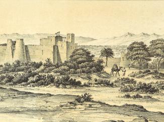
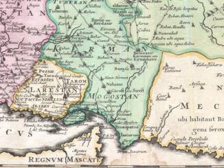
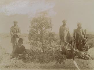
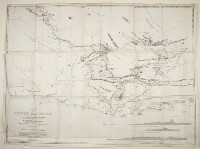
Correspondence, memoranda, maps and other papers relating to the establishment of a precise position of the frontier between Persia [Iran], British Baluchistan [in present-day Pakistan], and Afghanistan, arising in response to the proposed transfer to Persian ownership of the Mirjawa [Mīrjāveh] to Duzdap [Zahedan] stretch of the North Western Railway, and territorial claims made by the Khan of Kalat, Mir Mohammad Azam Jan Khan, and the Persian Government. The volume’s correspondents include: Foreign Office and India Office The department of the British Government to which the Government of India reported between 1858 and 1947. The successor to the Court of Directors. officials; the British Legation at Tehran (Reginald Hervey Hoare; Charles Dodd); the Government of India (Francis Verner Wylie); the Agent to Governor-General and Chief Commissioner for Baluchistan (Alexander Norman Ley Cater); the British Consul for Sīstān and Kain [Ka’īn] (Clive Kirkpatrick Daly).
The correspondence covers:
- The historical basis for negotiations, being surveys carried out in the 1870s, and a demarcation agreement concluded on 24 March 1896 by Colonel Thomas Hungerford Holdich, later referred to as the Holdich Line. Papers include correspondence from the 1930s in response to uncertainties about the precise position of the line (including extracts of the agreement in Persian), and copies of correspondence from 1895-1896 relating to the conclusion of Holdich’s agreement.
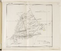
- Arrangements in 1932 for a joint British and Persian survey party to map the frontier, with Captain Guy Bomford of the Survey of India leading the British party. The results of Bomford’s survey are summarised in a copy of a secret letter, dated 9 June 1932, with accompanying maps (ff 113-119).
- Extent and format
- 1 volume (323 folios)
- It is grouped into
- 2 imagesRef: IOR/L/PS/12/3425, f 142 imagesRef: IOR/L/PS/12/3425, f 392 imagesRef: IOR/L/PS/12/3425, f 402 imagesRef: IOR/L/PS/12/3425, f 542 imagesRef: IOR/L/PS/12/3425, f 552 imagesRef: IOR/L/PS/12/3425, f 562 imagesRef: IOR/L/PS/12/3425, f 572 imagesRef: IOR/L/PS/12/3425, f 582 imagesRef: IOR/L/PS/12/3425, f 1012 imagesRef: IOR/L/PS/12/3425, f 1152 imagesRef: IOR/L/PS/12/3425, f 1182 imagesRef: IOR/L/PS/12/3425, f 1192 imagesRef: IOR/L/PS/12/3425, f 2582 imagesRef: IOR/L/PS/12/3425, f 2822 imagesRef: IOR/L/PS/12/3425, f 2922 imagesRef: IOR/L/PS/12/3425, f 306
- Arrangement
The papers are arranged in approximate chronological order from the rear to the front of the file.
- Physical characteristics
Foliation: the foliation sequence (used for referencing) commences at the first folio with 1 and terminates at the last folio with 321; these numbers are written in pencil, are circled, and are located in the top right corner of the recto The front of a sheet of paper or leaf, often abbreviated to 'r'. side of each folio. The foliation sequence does not include the front and back covers, nor does it include the two leading and two ending flyleaves.
A previous foliation sequence, which is also circled, has been superseded and therefore crossed out.
- Written in
- English and Persian in Latin and Arabic script
- Type
- Archival file
Archive information for this record
- Original held at
- British Library: India Office The department of the British Government to which the Government of India reported between 1858 and 1947. The successor to the Court of Directors. Records and Private Papers Documents collected in a private capacity.
- Access conditions
Unrestricted
- Archive reference
- IOR/L/PS/12/3425
- Former external reference(s)
- Coll 28/28
- Date(s)
- 14 Apr 1924-20 Nov 1935 (CE, Gregorian)
Access & Reference
History of this record
Related search terms
- Subjects
- SurveysFrontiersBilateral agreementsMaps
- Places
- PersiaAfghanistanMirjawaBaluchistan
- People & organisations
- Government of Iran, Pahlavi dynastyBritish Legation, TehranForeign OfficeBritish Consul, Seistan and KainKhan of Kalāt, rulers of KalātAgent to the Governor-General, Resident and Chief Commissioner, BaluchistanPerso-Baluch Boundary CommissionGovernment of India
Use and share this record
- Share this record
- Cite this record in your research
Coll 28/28 ‘Persia. Perso-Baluchistan Frontier. Demarcation near Mirjawa.’, British Library: India Office Records and Private Papers, IOR/L/PS/12/3425, in Qatar Digital Library <https://www.qdl.qa/archive/81055/vdc_100000000602.0x0003d2> [accessed 19 April 2024]
- Link to this record
https://www.qdl.qa/en/archive/81055/vdc_100000000602.0x0003d2
- IIIF details
This record has a IIIF manifest available as follows. If you have a compatible viewer you can drag the icon to load it.https://www.qdl.qa/en/iiif/81055/vdc_100000000602.0x0003d2/manifestOpen in Universal viewerOpen in Mirador viewerMore options for embedding images
Copyright: How to use this content
- Reference
- IOR/L/PS/12/3425
- Title
- Coll 28/28 ‘Persia. Perso-Baluchistan Frontier. Demarcation near Mirjawa.’
- Pages
- 186r:186v, 180r:180v, 38r:38v
- Author
- Unknown
- Usage terms
- The copyright status is unknown. Please contact copyright@bl.uk with any information you have regarding this item.
- Reference
- IOR/L/PS/12/3425
- Title
- Coll 28/28 ‘Persia. Perso-Baluchistan Frontier. Demarcation near Mirjawa.’
- Pages
- 174r:174v
- Author
- Feroughi, Mirza Mohamed Ali Kha
- Usage terms
- The copyright status is unknown. Please contact copyright@bl.uk with any information you have regarding this item.
- Reference
- IOR/L/PS/12/3425
- Title
- Coll 28/28 ‘Persia. Perso-Baluchistan Frontier. Demarcation near Mirjawa.’
- Pages
- 161r:162v
- Author
- Government of Iran
- Usage terms
- The copyright status is unknown. Please contact copyright@bl.uk with any information you have regarding this item.
- Reference
- IOR/L/PS/12/3425, f 14
- Title
- ‘Rough sketch of Northern Section of Perso-Baluch Frontier’
- Pages
- 14r:14v
- Author
- East India Company, the Board of Control, the India Office, or other British Government Department
- Usage terms
- Public Domain
- Reference
- IOR/L/PS/12/3425, f 101
- Title
- Sketch map of the frontier between Persia, Baluchistan and Afghanistan
- Pages
- 101r:101v
- Author
- East India Company, the Board of Control, the India Office, or other British Government Department
- Usage terms
- Public Domain
- Reference
- IOR/L/PS/12/3425, f 119
- Title
- ‘Part of Perso-Baluch Frontier’
- Pages
- 119r:119v
- Author
- East India Company, the Board of Control, the India Office, or other British Government Department
- Usage terms
- Public Domain
- Reference
- IOR/L/PS/12/3425, f 282
- Title
- ‘Sketch-map of the Perso-Baluchistan frontier north & south of Mirjawa.’
- Pages
- 282r:282v
- Author
- East India Company, the Board of Control, the India Office, or other British Government Department
- Usage terms
- Public Domain
- Reference
- IOR/L/PS/12/3425, f 292
- Title
- Hand drawn map showing the course of the North Western Railway between Duzdap [Zahedan] and Dalbandin
- Pages
- 292r:292v
- Author
- East India Company, the Board of Control, the India Office, or other British Government Department
- Usage terms
- Public Domain
- Reference
- IOR/L/PS/12/3425
- Title
- Coll 28/28 ‘Persia. Perso-Baluchistan Frontier. Demarcation near Mirjawa.’
- Pages
- front, back, spine, edge, head, tail, front-i, i-r:ii-v, 1r:13v, 15r:37v, 41r:53v, 59r:100v, 102r:114v, 116r:117v, 120r:160v, 163r:173v, 175r:179v, 181r:185v, 187r:257v, 259r:281v, 283r:291v, 293r:305v, 307r:321r, back-i, iii-r:iv-v, back-i
- Author
- East India Company, the Board of Control, the India Office, or other British Government Department
- Usage terms
- Open Government Licence
- Reference
- IOR/L/PS/12/3425, f 39
- Title
- ‘Copy of Map showing Territories adjacent to the Frontier’
- Pages
- 39r:39v
- Author
- East India Company, the Board of Control, the India Office, or other British Government Department
- Usage terms
- Open Government Licence
- Reference
- IOR/L/PS/12/3425, f 40
- Title
- ‘Beluchistan comprising Mekran and the Perso-Beluch Boundary.’
- Pages
- 40r:40v
- Author
- East India Company, the Board of Control, the India Office, or other British Government Department
- Usage terms
- Open Government Licence
- Reference
- IOR/L/PS/12/3425, f 54
- Title
- Map of Sir Henry Mortimer Durand’s proposed frontier between Persia and Baluchistan
- Pages
- 54r:54v
- Author
- East India Company, the Board of Control, the India Office, or other British Government Department
- Usage terms
- Open Government Licence
- Reference
- IOR/L/PS/12/3425, f 55
- Title
- Map showing part of the Perso-Baluchistan frontier
- Pages
- 55r:55v
- Author
- East India Company, the Board of Control, the India Office, or other British Government Department
- Usage terms
- Open Government Licence
- Reference
- IOR/L/PS/12/3425, f 56
- Title
- ‘Koh-i-Malik Siah from Survey by Mr. G. P. Tate’
- Pages
- 56r:56v
- Author
- East India Company, the Board of Control, the India Office, or other British Government Department
- Usage terms
- Open Government Licence
- Reference
- IOR/L/PS/12/3425, f 57
- Title
- ‘Copy of the Survey of India map of Baluchistan. Published in 1894.’
- Pages
- 57r:57v
- Author
- East India Company, the Board of Control, the India Office, or other British Government Department
- Usage terms
- Open Government Licence
- Reference
- IOR/L/PS/12/3425, f 58
- Title
- ‘Map of Western Baluchistan’
- Pages
- 58r:58v
- Author
- East India Company, the Board of Control, the India Office, or other British Government Department
- Usage terms
- Open Government Licence
- Reference
- IOR/L/PS/12/3425, f 115
- Title
- ‘Perso-Balūch Boundary from B.P. 11 to Kūh-i-Malik Sīāh’
- Pages
- 115r:115v
- Author
- East India Company, the Board of Control, the India Office, or other British Government Department
- Usage terms
- Open Government Licence
- Reference
- IOR/L/PS/12/3425, f 118
- Title
- ‘India and adjacent countries’
- Pages
- 118r:118v
- Author
- East India Company, the Board of Control, the India Office, or other British Government Department
- Usage terms
- Open Government Licence
- Reference
- IOR/L/PS/12/3425, f 258
- Title
- Map of the frontier region between Persia, Afghānistān and Balūchistān
- Pages
- 258r:258v
- Author
- East India Company, the Board of Control, the India Office, or other British Government Department
- Usage terms
- Open Government Licence
- Reference
- IOR/L/PS/12/3425, f 306
- Title
- Map showing the route of the North Western Railway from Duzdap [Zahedan] to Nok Kondī [Nok Kundi] and beyond
- Pages
- 306r:306v
- Author
- East India Company, the Board of Control, the India Office, or other British Government Department
- Usage terms
- Open Government Licence