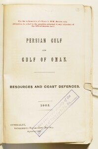
'PERSIAN GULF AND GULF OF OMAN. RESOURCES AND COAST DEFENCES.'
IOR/L/PS/20/C74


114 items in this record
Search within this record
The record is made up of 56 folios. It was created in 1903. It was written in English. The original is part of the British Library: India Office The department of the British Government to which the Government of India reported between 1858 and 1947. The successor to the Court of Directors. Records and Private Papers Documents collected in a private capacity. .
About this record
- Content
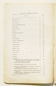
Printed report published by the Intelligence Department of the Admiralty, 1903. The report includes advice on collecting information on defences such as defended areas, minefields, ordnance, under-water defences. Much of the information was extracted from the Persian Gulf The historical term used to describe the body of water between the Arabian Peninsula and Iran. Report, 1898.
There are details on Muscat; Mussandam Promontory; Khor Kawi [Khawr al Quway‘], Elphinstone Inlet [Khawr ash Shamm], Khasab; Pirate Coast; Bahrain; Kuwait; Fao [Al Fāw]; Basra; Bushire; Lingah; Bundar Abbas [Bandar Abbas].
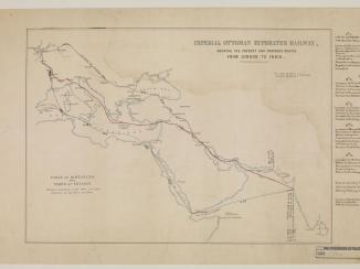
Also included is an 'Official statement of British Policy with regard to (1) the proposed Baghdad Railway; and (2) Persia and the Persian Gulf The historical term used to describe the body of water between the Arabian Peninsula and Iran. generally' given in the House of Lords, May 5, 1903.
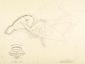
Maps include: rough sketch of operations in the vicinity and Bushire from the 3rd to the 10th February 1857 (Reproduced from Outram's Persian Campaign 1857); sketch of the attack on the batteries of Mohumra [Khorramshahr]: combined naval and military forces under command of Sir James Outram; sketch of the ground in the neighbourhood of Ahwaz [Ahvāz] on the Karun [Kārūn], showing the position occupied by the Persian Army, and the advance of the British detachment upon the town, March 1857. At the back of the report there is a large fold-out map: General Outline Map of the Persian Gulf The historical term used to describe the body of water between the Arabian Peninsula and Iran. showing Submarine Cables and the Principal Places mentioned in the Report.
- Extent and format
- 56 folios
- Physical characteristics
Foliation: There is a foliation sequence, which is circled in pencil, in the top right corner of the recto The front of a sheet of paper or leaf, often abbreviated to 'r'. of each folio. It begins on the front cover, on number 1, and ends on a map that is stored in a sleeve at the back of the volume, on number 57.
- Written in
- English in Latin script
- Type
- Archival file
Archive information for this record
- Original held at
- British Library: India Office The department of the British Government to which the Government of India reported between 1858 and 1947. The successor to the Court of Directors. Records and Private Papers Documents collected in a private capacity.
- Access conditions
Unrestricted
- Archive reference
- IOR/L/PS/20/C74
- Former external reference(s)
- C 74
- Date(s)
- 1903 (CE, Gregorian)
Access & Reference
History of this record
Related search terms
- Subjects
- Military operationsDefences
- Places
- Persian GulfGulf of Oman
- People & organisations
- Admiralty, Naval Intelligence Department
Use and share this record
- Share this record
- Cite this record in your research
'PERSIAN GULF AND GULF OF OMAN. RESOURCES AND COAST DEFENCES.', British Library: India Office Records and Private Papers, IOR/L/PS/20/C74, in Qatar Digital Library <https://www.qdl.qa/archive/81055/vdc_100000000884.0x000141> [accessed 24 April 2024]
- Link to this record
https://www.qdl.qa/en/archive/81055/vdc_100000000884.0x000141
- IIIF details
This record has a IIIF manifest available as follows. If you have a compatible viewer you can drag the icon to load it.https://www.qdl.qa/en/iiif/81055/vdc_100000000884.0x000141/manifestOpen in Universal viewerOpen in Mirador viewerMore options for embedding images
Copyright: How to use this content
- Reference
- IOR/L/PS/20/C74
- Title
- 'PERSIAN GULF AND GULF OF OMAN. RESOURCES AND COAST DEFENCES.'
- Pages
- front, front-i, i-r:i-v, 1:12, 12a:12b, 13:62, 62a:62b, 63:78, 78a:78b, 79:86, 86a:86b, 87:88, 88a:88d, 89:94, ii-r:ii-v, back-i, back
- Author
- East India Company, the Board of Control, the India Office, or other British Government Department
- Usage terms
- Open Government Licence