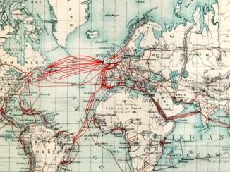
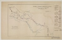
‘Imperial Ottoman Euphrates Railway, shewing the Present and Proposed Routes from London to India by Sir John Macneill and Telford Macneill, Engineers’
IOR/X/2964
2 items in this record
Search within this record
The record is made up of 1 map sheet. It was created in c 1860. It was written in English. The original is part of the British Library: Map Collections.
About this record
- Content
Distinctive Features:
Proposed route shown by pecked line.
Includes a MS table of distances and times of transit with railways speed reckoned at 25 miles per hour, and steamers at 12 miles per hour.
- Extent and format
- 1 map sheet
- Area map covers
- Map loading...
- Scale
- not given
- Scale designator
- Horizontal
- Orientation
- North
- Degree coordinates
- Top-left: 51° 45' 34.2" N, -1° 26' 44.88" W
Top-right: 51° 45' 34.2" N, 82° 21' 11.52" E
Bottom-left: 5° 2' 55.32" N, -1° 26' 44.88" W
Bottom-right: 5° 2' 55.32" N, 82° 21' 11.52" E - Physical characteristics
Dimensions: 293 x 421 mm, on sheet 354 x 559 mm
- Written in
- English in Latin script
- Type
- Map
Archive information for this record
- Original held at
- British Library: Map Collections
- Access conditions
Unrestricted
- Archive reference
- IOR/X/2964
- Former external reference(s)
- L.XIII.9
- Date(s)
- c 1860 (CE, Gregorian)
Access & Reference
History of this record
Related material
Related search terms
- Places
- Muscat
Use and share this record
- Share this record
- Cite this record in your research
‘Imperial Ottoman Euphrates Railway, shewing the Present and Proposed Routes from London to India by Sir John Macneill and Telford Macneill, Engineers’, British Library: Map Collections, IOR/X/2964, in Qatar Digital Library <https://www.qdl.qa/archive/81055/vdc_100000000926.0x0000ef> [accessed 23 April 2024]
- Link to this record
https://www.qdl.qa/en/archive/81055/vdc_100000000926.0x0000ef
- IIIF details
This record has a IIIF manifest available as follows. If you have a compatible viewer you can drag the icon to load it.https://www.qdl.qa/en/iiif/81055/vdc_100000000926.0x0000ef/manifestOpen in Universal viewerOpen in Mirador viewerMore options for embedding images
Copyright: How to use this content
- Reference
- IOR/X/2964
- Title
- ‘Imperial Ottoman Euphrates Railway, shewing the Present and Proposed Routes from London to India by Sir John Macneill and Telford Macneill, Engineers’
- Pages
- 1r:1v
- Author
- East India Company, the Board of Control, the India Office, or other British Government Department
- Usage terms
- Open Government Licence