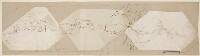
A photographic copy of 'Route map of the special mission to Seistan and Mekran by Quartermaster-Sergeant David Bower, Royal Engineers'
IOR/X/3126/2

2 items in this record
Search within this record
The record is made up of 1 map sheet. It was created in before 1872. It was written in English. The original is part of the British Library: Map Collections.
About this record
- Content
Distinctive Features:
This is a photograph of the original manuscript which is held at IOR/X/3126/1. Reduced version of this map was lithographed A lithograph is an image reproduced from a printing plate whose image areas attract ink and non-image areas repel it. and published in 1872 to accompany the Journal of Captain C. Bean Euan Smith. Printed copies at IOR/X/3126/3/1 and IOR/X/3126/3/2.
Relief shown by hachures.
Route of mission indicated in line with sextan observations points shown by dots. Boundaries of provinces coloured for reference on the original map.
Inscriptions:
Legends and annotations concerning the place names obscured via the reproduction process.
On recto The front of a sheet of paper or leaf, often abbreviated to 'r'. place names illegible or obscured through the reproduction process added in ink and pencil.
- Extent and format
- 1 map sheet
- Area map covers
- Map loading...
- Scale
- not given
- Scale designator
- Horizontal
- Orientation
- North
- Degree coordinates
- Top-left: 32° 50' 12.12" N, 51° 16' 43.32" E
Top-right: 32° 50' 12.12" N, 62° 40' 15.24" E
Bottom-left: 25° 1' 6.6" N, 51° 16' 43.32" E
Bottom-right: 25° 1' 6.6" N, 62° 40' 15.24" E - Physical characteristics
Materials:
Photographic print with additions in pen and ink and pencil
Dimensions:
260 x 968 mm
- Written in
- English in Latin script
- Type
- Map
Archive information for this record
- Original held at
- British Library: Map Collections
- Access conditions
Unrestricted
- Archive reference
- IOR/X/3126/2
- Former external reference(s)
- M.V.34
- Date(s)
- before 1872 (CE, Gregorian)
Access & Reference
History of this record
Related material
Related search terms
- Places
- Iran
Use and share this record
- Share this record
- Cite this record in your research
A photographic copy of 'Route map of the special mission to Seistan and Mekran by Quartermaster-Sergeant David Bower, Royal Engineers', British Library: Map Collections, IOR/X/3126/2, in Qatar Digital Library <https://www.qdl.qa/archive/81055/vdc_100000006832.0x000001> [accessed 20 April 2024]
- Link to this record
https://www.qdl.qa/en/archive/81055/vdc_100000006832.0x000001
- IIIF details
This record has a IIIF manifest available as follows. If you have a compatible viewer you can drag the icon to load it.https://www.qdl.qa/en/iiif/81055/vdc_100000006832.0x000001/manifestOpen in Universal viewerOpen in Mirador viewerMore options for embedding images
Copyright: How to use this content
- Reference
- IOR/X/3126/2
- Title
- A photographic copy of 'Route map of the special mission to Seistan and Mekran by Quartermaster-Sergeant David Bower, Royal Engineers'
- Pages
- 1r:1v
- Author
- Please see item description
- Usage terms
- Public Domain