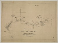
'Route across Arabia from El Katif in the Persian Gulf to Yambo in the Red Sea. Completed from the fournal [journal] of Capt. Sadleir'
IOR/X/3215

2 items in this record
Search within this record
The record is made up of 1 map sheet. It was created in c 1821. It was written in English. The original is part of the British Library: Map Collections.
About this record
- Content
Inscriptions:
On verso The back of a sheet of paper or leaf, often abbreviated to 'v'. : '6 Oct. 1821'.
- Extent and format
- 1 map sheet
- Area map covers
- Map loading...
- Scale
- not given
- Scale designator
- Horizontal
- Orientation
- North
- Degree coordinates
- Top-left: 26° 19' 48" N, 36° 57' 36" E
Top-right: 26° 19' 48" N, 50° 47' 60" E
Bottom-left: 22° 46' 48" N, 36° 57' 36" E
Bottom-right: 22° 46' 48" N, 50° 47' 60" E - Physical characteristics
Materials:
Pen and ink on paper
Dimensions:
290 x 430 mm
- Written in
- English in Latin script
- Type
- Map
Archive information for this record
- Original held at
- British Library: Map Collections
- Access conditions
Unrestricted
- Archive reference
- IOR/X/3215
- Former external reference(s)
- M.VIII.49
- Date(s)
- c 1821 (CE, Gregorian)
Access & Reference
History of this record
Related material
Use and share this record
- Share this record
- Cite this record in your research
'Route across Arabia from El Katif in the Persian Gulf to Yambo in the Red Sea. Completed from the fournal [journal] of Capt. Sadleir', British Library: Map Collections, IOR/X/3215, in Qatar Digital Library <https://www.qdl.qa/archive/81055/vdc_100000006858.0x000001> [accessed 23 April 2024]
- Link to this record
https://www.qdl.qa/en/archive/81055/vdc_100000006858.0x000001
- IIIF details
This record has a IIIF manifest available as follows. If you have a compatible viewer you can drag the icon to load it.https://www.qdl.qa/en/iiif/81055/vdc_100000006858.0x000001/manifestOpen in Universal viewerOpen in Mirador viewerMore options for embedding images
Copyright: How to use this content
- Reference
- IOR/X/3215
- Title
- 'Route across Arabia from El Katif in the Persian Gulf to Yambo in the Red Sea. Completed from the fournal [journal] of Capt. Sadleir'
- Pages
- 1r:1v
- Author
- Unknown
- Usage terms
- The copyright status is unknown. Please contact copyright@bl.uk with any information you have regarding this item.