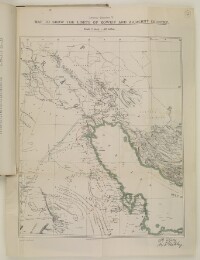
‘Map to show the Limits of Koweit and Adjacent Country’
IOR/R/15/1/741, f 7
2 items in this record
Search within this record
The record is made up of 1 map. It was created in 1913. It was written in English. The original is part of the British Library: India Office The department of the British Government to which the Government of India reported between 1858 and 1947. The successor to the Court of Directors. Records and Private Papers Documents collected in a private capacity. .
About this record
- Content
Imprint:
Harrison & Sons Lith. St. Martins Lane, W.C.
Distinctive Features:
Relief shown by hachures.
Map issued as an Annex no. 5 to Anglo-Ottoman Convention of 29 July 1913 with inner and outer limits of Kuwait authority shown by red and green lines respectively. Signatures of Sir Edward Grey and Ibrahim Hakki Pasha An Ottoman title used after the names of certain provincial governors, high-ranking officials and military commanders. in the bottom right-hand corner.
- Extent and format
- 1 map
- Area map covers
- Map loading...
- Scale
- Scale approximately 1:3,000,000
- Scale designator
- Horizontal
- Orientation
- North
- Degree coordinates
- Top-left: 34° 15' 54" N, 43° 33' 58.68" E
Top-right: 34° 15' 54" N, 53° 59' 59.64" E
Bottom-left: 23° 52' 5.88" N, 43° 33' 58.68" E
Bottom-right: 23° 52' 5.88" N, 53° 59' 59.64" E - It is part of
- 98 imagesRef: IOR/R/15/1/741
- Physical characteristics
Dimensions:
380 x 325 mm, on sheet 495 x 380 mm
- Written in
- English in Latin script
- Type
- Map
Archive information for this record
- Original held at
- British Library: India Office The department of the British Government to which the Government of India reported between 1858 and 1947. The successor to the Court of Directors. Records and Private Papers Documents collected in a private capacity.
- Access conditions
Unrestricted
- Archive reference
- IOR/R/15/1/741, f 7
- Date(s)
- 1913 (CE, Gregorian)
Access & Reference
History of this record
Related search terms
- Places
- Koweit
Use and share this record
- Share this record
- Cite this record in your research
‘Map to show the Limits of Koweit and Adjacent Country’, British Library: India Office Records and Private Papers, IOR/R/15/1/741, f 7, in Qatar Digital Library <https://www.qdl.qa/archive/81055/vdc_100023253361.0x000007> [accessed 19 April 2024]
- Link to this record
https://www.qdl.qa/en/archive/81055/vdc_100023253361.0x000007
- IIIF details
This record has a IIIF manifest available as follows. If you have a compatible viewer you can drag the icon to load it.https://www.qdl.qa/en/iiif/81055/vdc_100000000193.0x0002cc/manifestOpen in Universal viewerOpen in Mirador viewerMore options for embedding images
Copyright: How to use this content
- Reference
- IOR/R/15/1/741, f 7
- Title
- ‘Map to show the Limits of Koweit and Adjacent Country’
- Pages
- 7r:7v
- Author
- East India Company, the Board of Control, the India Office, or other British Government Department
- Usage terms
- Open Government Licence