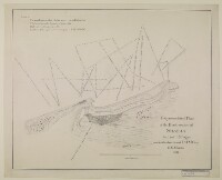
‘Trigonometrical Plan of the Back-water at Sharja by Lieut.t R. Cogan under the direction of Lt. J.M. Guy, H.C.Marine. 1822’
IOR/X/3689
2 items in this record
Search within this record
The record is made up of 1 map. It was created in 1822. It was written in English and Arabic. The original is part of the British Library: Map Collections.
About this record
- Content
Distinctive Features:
Depths shown by soundings Measurements of the depth of a body of water. .
Hand drawn nautical chart of the shores of the Persian Gulf The historical term used to describe the body of water between the Arabian Peninsula and Iran. compiled from the survey carried out by the Bombay Marine’s officers in 1822 showing Sharja [Sharjah, United Arab Emirates] with the location of fresh water wells marked.
Place names given both in English and Arabic.
Includes note on water levels and soundings Measurements of the depth of a body of water. with latitude and longitude of a ‘square tower’ reported.
- Extent and format
- 1 map
- Area map covers
- Map loading...
- Scale
- Scale approximately 1:9,350
- Scale designator
- Horizontal
- Orientation
- North
- Degree coordinates
- Top-left: 25° 23' 34.68" N, 55° 20' 43.22" E
Top-right: 25° 23' 34.68" N, 55° 25' 42.19" E
Bottom-left: 25° 19' 38.63" N, 55° 20' 43.22" E
Bottom-right: 25° 19' 38.63" N, 55° 25' 42.19" E - Physical characteristics
Materials: Pen and ink on paper
Dimensions: 455 x 570 mm, on sheet 497 x 618 mm
- Written in
- English and Arabic in Latin and Arabic script
- Type
- Map
Archive information for this record
- Original held at
- British Library: Map Collections
- Access conditions
Unrestricted
- Archive reference
- IOR/X/3689
- Former external reference(s)
- U.VI.43
- Date(s)
- 1822 (CE, Gregorian)
Access & Reference
History of this record
Related search terms
- Places
- Sharjah
- People & organisations
- Robert CoganMichael HoughtonJohn M. Guy
Use and share this record
- Share this record
- Cite this record in your research
‘Trigonometrical Plan of the Back-water at Sharja by Lieut.t R. Cogan under the direction of Lt. J.M. Guy, H.C.Marine. 1822’, British Library: Map Collections, IOR/X/3689, in Qatar Digital Library <https://www.qdl.qa/archive/81055/vdc_100023278061.0x000001> [accessed 18 April 2024]
- Link to this record
https://www.qdl.qa/en/archive/81055/vdc_100023278061.0x000001
- IIIF details
This record has a IIIF manifest available as follows. If you have a compatible viewer you can drag the icon to load it.https://www.qdl.qa/en/iiif/81055/vdc_100023278061.0x000001/manifestOpen in Universal viewerOpen in Mirador viewerMore options for embedding images
Copyright: How to use this content
- Reference
- IOR/X/3689
- Title
- ‘Trigonometrical Plan of the Back-water at Sharja by Lieut.t R. Cogan under the direction of Lt. J.M. Guy, H.C.Marine. 1822’
- Pages
- 1r:1v
- Author
- Please see item description
- Usage terms
- Public Domain