!['Military Report on the Arabian Shores of the Persian Gulf, Kuwait, Bahrein, Hasa, Qatar, Trucial Oman and Oman' [‎68] (82/226)](https://iiif.qdl.qa/iiif/images/81055/vdc_100000000239.0x0001d1/IOR_L_MIL_17_15_141_0083.jp2/full/!1200,1200/0/default.jpg "'Military Report on the Arabian Shores of the Persian Gulf, Kuwait, Bahrein, Hasa, Qatar, Trucial Oman and Oman' [‎68] (82/226)")
'Military Report on the Arabian Shores of the Persian Gulf, Kuwait, Bahrein, Hasa, Qatar, Trucial Oman and Oman' [68] (82/226)
The record is made up of 1 volume (112 folios). It was created in 1933. It was written in English. The original is part of the British Library: India Office The department of the British Government to which the Government of India reported between 1858 and 1947. The successor to the Court of Directors. Records and Private Papers Documents collected in a private capacity. .
Transcription
This transcription is created automatically. It may contain errors.
68
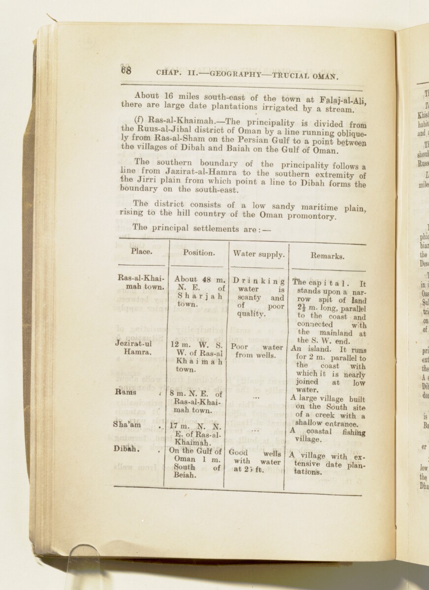
chap. ii, geography tpucial oman.
About 16 miles south-east of the town at Falaj-al-Ali
there are large date plantations irrigated by a stream. '
(f) Ras-al-Khaimah. The principality is divided from
the Ruus-al-Jibal district of Oman by a line running oblique-
y from Ras-al-Sham on the
Persian Gulf
The historical term used to describe the body of water between the Arabian Peninsula and Iran.
to a point between
the villages of Dibah and Baiah on the Gulf of Oman.
The southern boundary of the principality follows a
line trom Jazirat-al-Hamra to the southern extremitv of
the Jirn plain from which point a line to Dibah forms the
boundary on the south-east.
• ■ " ie . district consists of a low sandy maritime plain
rising to the hill country of the Oman promontory.
Place.
Position.
Water supply.
Ras-al-Khai
mah town.
About 48 m.
N. E. of
S h a r j a h
town.
Drinking
water is
scanty and
of poor
quality-
Jezirat-ul
Hamra.
12 in. W. S.
W. of Ras-al
Kh a i m a h
town.
Poor water
from wells.
Rams t
8 m. N. E. of
Ras-al-Khai-
mah town.
Sha'am
Dibkh.
17 m. N. N.
E. of Ras-al-
Khaimah.
On the Gulf of
Oman 1 m.
South of
Beiah.
Good wells
with water
at 2> ft.
Remarks.
The cap i t a 1 . It
stands upon a nar
row spit of land
2J m. long, parallel
to the coast and
connected w;th
the mainland at
the S. W. end.
An island. It runs
for 2 m. parallel to
the coast with
which it is nearly
joined at low
water.
A large village built
on the South site
of a creek with a
shallow entrance.
A coastal fishing
village.
A village with ex
tensive date plan
tations.
About this item
- Content
The volume is Military Report on the Arabian Shores of the Persian Gulf The historical term used to describe the body of water between the Arabian Peninsula and Iran. , Kuwait, Bahrein, Hasa, Qatar, Trucial Oman A name used by Britain from the nineteenth century to 1971 to refer to the present-day United Arab Emirates. and Oman (Calcutta: Government of India Press, 1933). The volume was produced by the General Staff, India. The place name Bahrain is rendered in the title and elsewhere in the volume in the spelling 'Bahrein'.
The volume contains information in separate sections for each of the places listed in the title under the following chapter headings:
- I Historical (ff 8-14);
- II Geography, Climate, Health (ff 15-54);
- III Population (ff 54-67);
- IV Water Supply; Resources (ff 68-70);
- V Armed Forces (ff 70-75);
- VI Aviation (ff 75-78);
- VII Political (ff 79-81);
- VIII Inter-Communication [wireless and telegraph] (ff 81-82);
- IX Communications [land routes] (ff 83-98).
There are three appendices, which follow the same format:
- I Currency, Weights and Measures (f 99-102);
- II Landing Facilities - Maritime (ff 103-106);
- III List of Maps (f 106).
The volume includes five maps of the region (ff 109-113).
- Extent and format
- 1 volume (112 folios)
- Arrangement
There is a list of contents on ff 6-7, which contains an inaccuracy in the title and number of the last chapter.
- Physical characteristics
Foliation: the foliation sequence commences at 1 on the front cover and terminates at 113 on the last of the five maps inserted in a pocket attached to the back cover. The numbers are written in pencil, are circled, and appear in the top right hand corner of the recto The front of a sheet of paper or leaf, often abbreviated to 'r'. page of each folio. All five maps (ff 109, 110, 111, 112, 113) need to folded out to be examined. This is the system used to determine the sequence of pages in the volume.
Pagination: an original printed pagination sequence, numbered 2-198 appears between ff 8-106.
- Written in
- English in Latin script View the complete information for this record
Use and share this item
- Share this item
'Military Report on the Arabian Shores of the Persian Gulf, Kuwait, Bahrein, Hasa, Qatar, Trucial Oman and Oman' [68] (82/226), British Library: India Office Records and Private Papers, IOR/L/MIL/17/15/141, in Qatar Digital Library <https://www.qdl.qa/archive/81055/vdc_100023509623.0x000054> [accessed 24 April 2024]
https://www.qdl.qa/en/archive/81055/vdc_100023509623.0x000054
Copy and paste the code below into your web page where you would like to embed the image.
<meta charset="utf-8"><a href="https://www.qdl.qa/en/archive/81055/vdc_100023509623.0x000054">'Military Report on the Arabian Shores of the Persian Gulf, Kuwait, Bahrein, Hasa, Qatar, Trucial Oman and Oman' [‎68] (82/226)</a> <a href="https://www.qdl.qa/en/archive/81055/vdc_100023509623.0x000054"> <img src="https://iiif.qdl.qa/iiif/images/81055/vdc_100000000239.0x0001d1/IOR_L_MIL_17_15_141_0083.jp2/full/!280,240/0/default.jpg" alt="" /> </a>
This record has a IIIF manifest available as follows. If you have a compatible viewer you can drag the icon to load it.https://www.qdl.qa/en/iiif/81055/vdc_100000000239.0x0001d1/manifestOpen in Universal viewerOpen in Mirador viewerMore options for embedding images
Copyright: How to use this content
- Reference
- IOR/L/MIL/17/15/141
- Title
- 'Military Report on the Arabian Shores of the Persian Gulf, Kuwait, Bahrein, Hasa, Qatar, Trucial Oman and Oman'
- Pages
- front, front-i, i-r:iii-r, ii-v, iv-r:iv-v, 1:4, 1:208, v-r:v-v, back-i, back
- Author
- East India Company, the Board of Control, the India Office, or other British Government Department
- Usage terms
- Open Government Licence