!['Military Report on the Arabian Shores of the Persian Gulf, Kuwait, Bahrein, Hasa, Qatar, Trucial Oman and Oman' [‎71] (85/226)](https://iiif.qdl.qa/iiif/images/81055/vdc_100000000239.0x0001d1/IOR_L_MIL_17_15_141_0086.jp2/full/!1200,1200/0/default.jpg "'Military Report on the Arabian Shores of the Persian Gulf, Kuwait, Bahrein, Hasa, Qatar, Trucial Oman and Oman' [‎71] (85/226)")
'Military Report on the Arabian Shores of the Persian Gulf, Kuwait, Bahrein, Hasa, Qatar, Trucial Oman and Oman' [71] (85/226)
The record is made up of 1 volume (112 folios). It was created in 1933. It was written in English. The original is part of the British Library: India Office The department of the British Government to which the Government of India reported between 1858 and 1947. The successor to the Court of Directors. Records and Private Papers Documents collected in a private capacity. .
Transcription
This transcription is created automatically. It may contain errors.
chap. ii. geography oman. 71
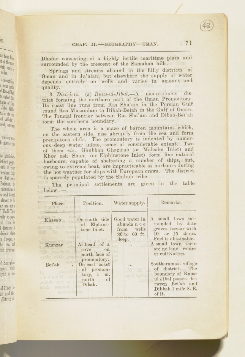
Dhofar consisting of a highly fertile maritime plain and
surrounded by the crescent of the Samahan hills.
Springs and streams abound in the hilly districts of
Oman and in Ja'alan, but elsewhere the supply of water
depends entirely on wells and varies in amount and
quality.
3. Districts, (a) Buus-ul-Jihal.—A mountainous dis
trict forming the northern part of the Oman Promontory.
Its coast line runs from Has Sha'am in the
Persian Gulf
The historical term used to describe the body of water between the Arabian Peninsula and Iran.
round Has Musandam to Dibah-Beiah in the Gidf of Oman.
The Trucial frontier between Has Sha'am and Dibah-Bei'ah
form the southern boundary.
The whole area is a maze of barren mountains which,
on the eastern side, rise abruptly from the sea and form
precipitous cliffs. The promontory is indented by numer
ous deep water inlets, some of considerable extent. Two
of them viz., Ghubbah Ghazirah (or Malcolm Inlet) and
Khor ash Sham (or Elphinstone Inlet) form fine natural
harbours, capable of sheltering a number of ships, but,
owing to extreme heat, are impracticable as harbours during
the hot weather for ships with European crews. The district
is sparsely populated by the Shihuh tribe.
The principal settlements are given in the table
below : —
Place.
Khasab
Kumzar
Bei'ah
Position.
On south side
of Elphins
tone Inlet.
At head of a
cove on
north face of
promontory.
On east coast
of promon
tory, 1 m.
north of
Dibah.
Water supply.
Remarks.
Good water in
abunda nee
from wells
30 to 60 ft.
deep.
A small town sur
rounded by date
groves, bazaar with
10 or 15 shops.
Fuel is obtainable.
A small town there
are no land routes
or cultivation.
Southernmost village
of district. The
boundary of Ruus-
ul Jibal passes be
tween Bei'ah and
Dibbah 1 mile S. E.
of it.
About this item
- Content
The volume is Military Report on the Arabian Shores of the Persian Gulf The historical term used to describe the body of water between the Arabian Peninsula and Iran. , Kuwait, Bahrein, Hasa, Qatar, Trucial Oman A name used by Britain from the nineteenth century to 1971 to refer to the present-day United Arab Emirates. and Oman (Calcutta: Government of India Press, 1933). The volume was produced by the General Staff, India. The place name Bahrain is rendered in the title and elsewhere in the volume in the spelling 'Bahrein'.
The volume contains information in separate sections for each of the places listed in the title under the following chapter headings:
- I Historical (ff 8-14);
- II Geography, Climate, Health (ff 15-54);
- III Population (ff 54-67);
- IV Water Supply; Resources (ff 68-70);
- V Armed Forces (ff 70-75);
- VI Aviation (ff 75-78);
- VII Political (ff 79-81);
- VIII Inter-Communication [wireless and telegraph] (ff 81-82);
- IX Communications [land routes] (ff 83-98).
There are three appendices, which follow the same format:
- I Currency, Weights and Measures (f 99-102);
- II Landing Facilities - Maritime (ff 103-106);
- III List of Maps (f 106).
The volume includes five maps of the region (ff 109-113).
- Extent and format
- 1 volume (112 folios)
- Arrangement
There is a list of contents on ff 6-7, which contains an inaccuracy in the title and number of the last chapter.
- Physical characteristics
Foliation: the foliation sequence commences at 1 on the front cover and terminates at 113 on the last of the five maps inserted in a pocket attached to the back cover. The numbers are written in pencil, are circled, and appear in the top right hand corner of the recto The front of a sheet of paper or leaf, often abbreviated to 'r'. page of each folio. All five maps (ff 109, 110, 111, 112, 113) need to folded out to be examined. This is the system used to determine the sequence of pages in the volume.
Pagination: an original printed pagination sequence, numbered 2-198 appears between ff 8-106.
- Written in
- English in Latin script View the complete information for this record
Use and share this item
- Share this item
'Military Report on the Arabian Shores of the Persian Gulf, Kuwait, Bahrein, Hasa, Qatar, Trucial Oman and Oman' [71] (85/226), British Library: India Office Records and Private Papers, IOR/L/MIL/17/15/141, in Qatar Digital Library <https://www.qdl.qa/archive/81055/vdc_100023509623.0x000057> [accessed 24 April 2024]
https://www.qdl.qa/en/archive/81055/vdc_100023509623.0x000057
Copy and paste the code below into your web page where you would like to embed the image.
<meta charset="utf-8"><a href="https://www.qdl.qa/en/archive/81055/vdc_100023509623.0x000057">'Military Report on the Arabian Shores of the Persian Gulf, Kuwait, Bahrein, Hasa, Qatar, Trucial Oman and Oman' [‎71] (85/226)</a> <a href="https://www.qdl.qa/en/archive/81055/vdc_100023509623.0x000057"> <img src="https://iiif.qdl.qa/iiif/images/81055/vdc_100000000239.0x0001d1/IOR_L_MIL_17_15_141_0086.jp2/full/!280,240/0/default.jpg" alt="" /> </a>
This record has a IIIF manifest available as follows. If you have a compatible viewer you can drag the icon to load it.https://www.qdl.qa/en/iiif/81055/vdc_100000000239.0x0001d1/manifestOpen in Universal viewerOpen in Mirador viewerMore options for embedding images
Copyright: How to use this content
- Reference
- IOR/L/MIL/17/15/141
- Title
- 'Military Report on the Arabian Shores of the Persian Gulf, Kuwait, Bahrein, Hasa, Qatar, Trucial Oman and Oman'
- Pages
- front, front-i, i-r:iii-r, ii-v, iv-r:iv-v, 1:4, 1:208, v-r:v-v, back-i, back
- Author
- East India Company, the Board of Control, the India Office, or other British Government Department
- Usage terms
- Open Government Licence