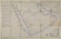
'Map of Maritime Arabia with the opposite coasts of Africa and Persia'
Mss Eur F126/99
2 items in this record
Search within this record
The record is made up of 1 map. It was created in 1 Mar 1856. It was written in English. The original is part of the British Library: India Office The department of the British Government to which the Government of India reported between 1858 and 1947. The successor to the Court of Directors. Records and Private Papers Documents collected in a private capacity. .
About this record
- Content
Imprint:
Lithographed A lithograph is an image reproduced from a printing plate whose image areas attract ink and non-image areas repel it. in the Chief Engineer's Office by E. Huskeljee and E. Kumroodeen, Bombay.
Distinctive Features:
Relief shown by hachures.
Below the title note ‘Reduced in the Quarter Master Generals Office from an Original Map by Colonel T Dickinson, Chief Engineer. Signed Neil Campbell, Lieutenant-Colonel, Acting Quarter Master General'.
A detailed explanation of the various surveys, expeditions and engraved charts used to compile the map from 1819 to 1839 is given along with descriptions of the various routes shown on the map, and others which were referred to in the compiling of this map. The description was compiled by the Chief Engineers Office, Bombay, 4 April 1843. Inscriptions:
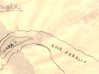
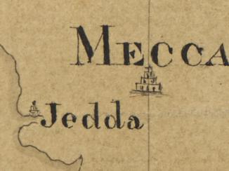
Numerous annotations concerning the routes, topography of the regions and local tribes, with submarine telegraph cable and two circles based on Ras Musandam and Bushire, inserted in black ink and pencil.
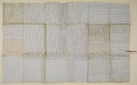
The verso The back of a sheet of paper or leaf, often abbreviated to 'v'. of the map contains a report written by Lewis Pelly, to the Chief Secretary to the Government of Bombay From c. 1668-1858, the East India Company’s administration in the city of Bombay [Mumbai] and western India. From 1858-1947, a subdivision of the British Raj. It was responsible for British relations with the Gulf and Red Sea regions. , 17 February 1863 on the landscape of the Persian Gulf The historical term used to describe the body of water between the Arabian Peninsula and Iran. , tribal ownership of coastline areas and pearl banks, and regarding the area surrounding Bushire. The report starts by describing the area from Kuwait to Dhahran, which Pelly claims is known as Adân [Al ‘Adān]; the area from Katiffe [Al Qaţīf] to Ojair [Al ‘Uqayr], which he refers to as Hujar, and the area from Ojair to the ports of the Beni Yas [Banī Yās] which he describes as Qatar. Within the Qatar area Pelly refers to Zabareh [Zubārah] which he describes as a place of note and considerable population and trade some 40 years previously. Pelly then proceeds to describe the areas the Wahabees [Wahhabi] claim ownership to; to describe the village of Cassab [Khaşab]; and to describe the pearl banks of the Persian Gulf The historical term used to describe the body of water between the Arabian Peninsula and Iran. , including their shared ownership, fishing processes, where the pearls are sold too, and how they are managed and patrolled during the pearl season. Further points made in the report include a possible overland route to Aden; and descriptions of Bushire including its agricultural population, estimated trade, taxes paid by local families. The report concludes by laying out possible ways in which the British Government and its armies could access Persia via Bushire or Hallilah [Heleh?] should they wish to launch a military offensive, including accessibility of various routes and the best times to travel on them.
- Extent and format
- 1 map
- Area map covers
- Map loading...
- Scale
- Scale not given
- Scale designator
- Horizontal
- Orientation
- North
- Degree coordinates
- Top-left: 30° 34' 12" N, 32° 11' 24" E
Top-right: 30° 34' 12" N, 61° 12' 0" E
Bottom-left: 12° 7' 12" N, 32° 11' 24" E
Bottom-right: 12° 7' 12" N, 61° 12' 0" E - Physical characteristics
Dimensions: 520 x 721 mm; on sheet 575 x 916 mm
Foliation: The map sheet has been foliated using a pencil number enclosed in a circle in the top right hand corner of the recto The front of a sheet of paper or leaf, often abbreviated to 'r'. of the sheet.
- Written in
- English in Latin script
- Type
- Map
Archive information for this record
- Original held at
- British Library: India Office The department of the British Government to which the Government of India reported between 1858 and 1947. The successor to the Court of Directors. Records and Private Papers Documents collected in a private capacity.
- Access conditions
Unrestricted
- Archive reference
- Mss Eur F126/99
- Date(s)
- 1 Mar 1856 (CE, Gregorian)
Access & Reference
History of this record
Related search terms
- Places
- Arabian Peninsula
- People & organisations
- Neil CampbellThomas Malcolm Dickinson
Use and share this record
- Share this record
- Cite this record in your research
'Map of Maritime Arabia with the opposite coasts of Africa and Persia', British Library: India Office Records and Private Papers, Mss Eur F126/99, in Qatar Digital Library <https://www.qdl.qa/archive/81055/vdc_100023514290.0x000001> [accessed 23 April 2024]
- Link to this record
https://www.qdl.qa/en/archive/81055/vdc_100023514290.0x000001
- IIIF details
This record has a IIIF manifest available as follows. If you have a compatible viewer you can drag the icon to load it.https://www.qdl.qa/en/iiif/81055/vdc_100023514290.0x000001/manifestOpen in Universal viewerOpen in Mirador viewerMore options for embedding images
Copyright: How to use this content
- Reference
- Mss Eur F126/99
- Title
- 'Map of Maritime Arabia with the opposite coasts of Africa and Persia'
- Pages
- 1r:1v
- Author
- East India Company, the Board of Control, the India Office, or other British Government Department
- Usage terms
- Open Government Licence