!['Military Report on South-West Persia, Including the Provinces of Khuzistan (Arabistan), Luristan, and Part of Fars' [‎293] (338/466)](https://iiif.qdl.qa/iiif/images/81055/vdc_100023517327.0x000001/V 8685_0366.jp2/full/!1200,1200/0/default.jpg "'Military Report on South-West Persia, Including the Provinces of Khuzistan (Arabistan), Luristan, and Part of Fars' [‎293] (338/466)")
'Military Report on South-West Persia, Including the Provinces of Khuzistan (Arabistan), Luristan, and Part of Fars' [293] (338/466)
The record is made up of 1 volume (390 pages). It was created in 1885. It was written in English. The original is part of the British Library: Printed Collections.
Transcription
This transcription is created automatically. It may contain errors.
293
%
R oute N o. leonid,
From hfaldti to Behhahdn and Bandar-Dildm, contd.
£
jS^
55
D istances in
miles,
Time.
Names of towns. Tillages, &c.
Interme- m . ,
diate. lotal •
Remarks.
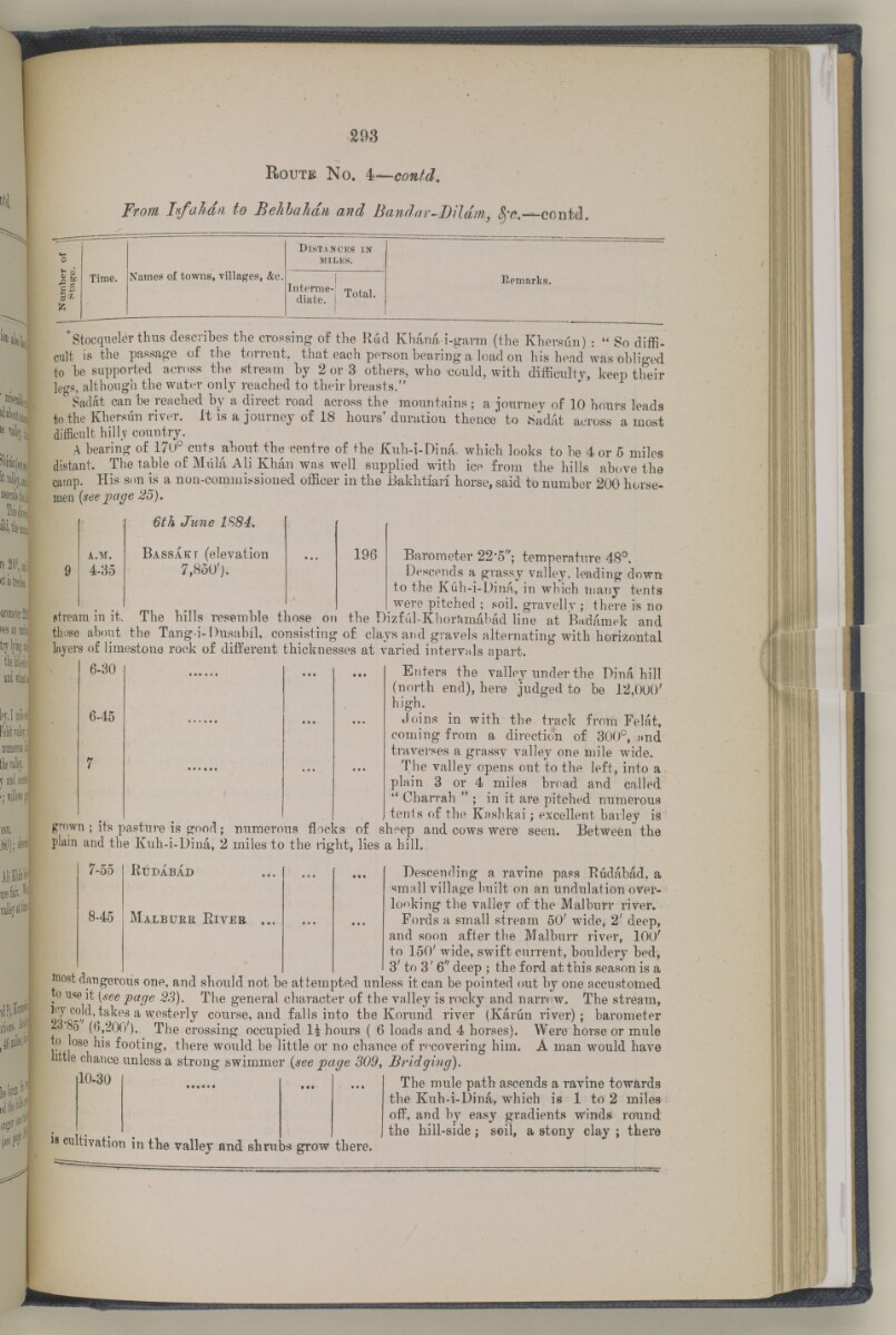
'Stocqueler thus describes the crossing of the Rud Khana i-gaim (the Khersun) : " So diffi
cult is the passage of the torrent, that each person bearing a load on his head was obliged
to be supported across the stream by 2 or 3 others, who could, with difficulty, keep their
leo-s, although the water only reached to their breasts."
Sadat can be reached by a direct road across the mountains; a journey of 10 hours leads
to the Khersun river. It is a journey of 18 hours' duration thence to .Sadat across a most
difficult hilly country.
A bearing of 170° cuts about the centre of the Kuh-i-Dina. which looks to be 4 or 5 miles
distant. The table of Mula Ali Khan was well supplied with ice from the hills above the
camp. His son is a non-commissioned officer in the Bakhtian horse, said to number 200 horse
men (seepage 25),
A.M.
4-85
6th June 1S84.
Bassart (elevation
7,850').
196
Barometer 22*5"; temperature 48°.
Descends a grassy valley, leading down
to the Kuh-i-Dina, in which tnanT tents
were pitched ; soil, gravelly ; there is no
stream in it. The hills resemble those on the Dizful-Khorkmabad line at Badamek and
those about the Tang-i-Dusabil, consisting of clays and gravels alternating with horizontal
layers of limestone rock of different thicknesses at varied intervals apart.
6-30 ...... ... ... Enters the valley under the Dina hill
(north end), here judged to be 12,000'
high.
6-45 ...... ... ... Joins in with the track from Felat,
coming from a direction of 300°, nnd
traverses a grassy valley one mile wide.
The valley opens out to the left, into a
plain 3 or 4 miles broad and called
" Charrah " ; in it are pitched numerous
tenis of the Kashkai; excellent barley is
grown ; its pasture is good; numerous flocks of sheep and cows were seen. Between the
plain and the Kuh-i-Dina, 2 miles to the right, lies a hill.
7-55
8-45
RtDABAD
Malbuee Eiver
Descending a ravine pass Eudabad, a
small village built on an undulation over
looking the valley of the Malburr river.
Fords a small stream 50' wide^ 2' deep,
and soon after the Malburr river, 100'
to 150' wide, swift current, bouldery bed,
3' to 3' 6" deep ; the ford at this season is a
®ost dangerous one, and should not be attempted unless it can be pointed out by one accustomed
o use it [see page 28). The general character of the valley is rocky and narrow. The stream,
l;T cold, takes a westerly course, and falls into the Korund river {Karun river); barometer
^ ^ (6,200'). The crossing occupied li hours ( 6 loads and 4 horses). Were horse or mule
to lose his footing, there would be little or no chance of recovering him. A man would have
little chance unless a strong swimmer {see page 309, Bridging).
10-30
is cultivation in the valley and shrubs grow there.
The mule path ascends a ravine towards
the Kuh-i-Dina, which is 1 to 2 miles
ofP, and by easy gradients winds round
the hill-side; soil, a stony clay ; there
About this item
- Content
Military Report on South-West Persia, Including the Provinces of Khuzistan (Arabistan), Luristan, and Part of Fars by Major and Bt. Lieut-Col. Mark S. Bell, V.C., R.E.
Publication Details: Simla: Government Central Branch Press, 1885. Prepared in the Intelligence Branch of the Quarter Master General's Department in India.
Physical Description: 3 maps in end pockets. 41 plates.
- Extent and format
- 1 volume (390 pages)
- Arrangement
This volume contains a table of contents giving chapter headings and page references.
- Physical characteristics
Dimensions: 245mm x 150mm
- Written in
- English in Latin script View the complete information for this record
Use and share this item
- Share this item
'Military Report on South-West Persia, Including the Provinces of Khuzistan (Arabistan), Luristan, and Part of Fars' [293] (338/466), British Library: Printed Collections, V 8685, in Qatar Digital Library <https://www.qdl.qa/archive/81055/vdc_100023694940.0x000089> [accessed 25 April 2024]
https://www.qdl.qa/en/archive/81055/vdc_100023694940.0x000089
Copy and paste the code below into your web page where you would like to embed the image.
<meta charset="utf-8"><a href="https://www.qdl.qa/en/archive/81055/vdc_100023694940.0x000089">'Military Report on South-West Persia, Including the Provinces of Khuzistan (Arabistan), Luristan, and Part of Fars' [‎293] (338/466)</a> <a href="https://www.qdl.qa/en/archive/81055/vdc_100023694940.0x000089"> <img src="https://iiif.qdl.qa/iiif/images/81055/vdc_100023517327.0x000001/V 8685_0366.jp2/full/!280,240/0/default.jpg" alt="" /> </a>
This record has a IIIF manifest available as follows. If you have a compatible viewer you can drag the icon to load it.https://www.qdl.qa/en/iiif/81055/vdc_100023517327.0x000001/manifestOpen in Universal viewerOpen in Mirador viewerMore options for embedding images
Copyright: How to use this content
- Reference
- V 8685
- Title
- 'Military Report on South-West Persia, Including the Provinces of Khuzistan (Arabistan), Luristan, and Part of Fars'
- Pages
- front, back, spine, edge, head, tail, front-i, 1:4, i-r:ii-v, 1:8, 1:2, 2a:2b, 3:4, 4a:4b, 5:40, 40a:40b, 41:54, 54a:54b, 55:60, 60a:60b, 61:64, 64a:64b, 65:96, 96a:96b, 97:98, 98a:98b, 99:108, 108a:108b, 109:112, 112a:112b, 113:116, 116a:116b, 167:176, 176a:176b, 177:178, 178a:178b, 179:184, 184a:184b, 185:190, 190a:190d, 191:192, 192a:192b, 193:204, 204a:204b, 205:208, 208a:208d, 209:210, 210a:210b, 211:212, 212a:212b, 213:230, 230a:230b, 231:236, 236a:236b, 237:240, 240a:240b, 241:244, 244a:244d, 245:246, 246a:246b, 247:248, 248a:248b, 249:252, 252a:252b, 253:254, 254a:254b, 255:264, 264a:264b, 265:270, 270a:270b, 271:272, 272a:272d, 273:334, 334a:334b, 335:366, 366a:366n, 367:390, 1:10, iii-r:iv-v, 1:2, back-i
- Author
- Bell, Mark Sever
- Usage terms
- Public Domain