![‘Map No. I. Sketch Map of Shaiba Defences’ [‎45] (1/1)](https://iiif.qdl.qa/iiif/images/81055/vdc_100000000239.0x0001a3/IOR_L_MIL_17_15_95_0073.jp2/full/!1200,1200/0/default.jpg "‘Map No. I. Sketch Map of Shaiba Defences’ [‎45] (1/1)")
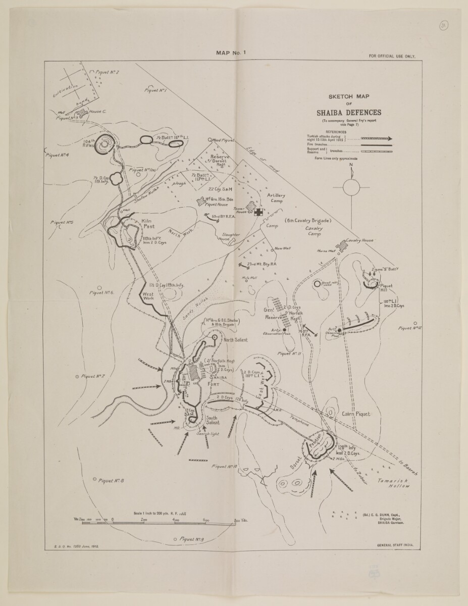
‘Map No. I. Sketch Map of Shaiba Defences’ [45] (1/1)
The record is made up of 1 map. It was created in Jun 1915. It was written in English. The original is part of the British Library: India Office The department of the British Government to which the Government of India reported between 1858 and 1947. The successor to the Court of Directors. Records and Private Papers Documents collected in a private capacity. .
Transcription
This transcription is created automatically. It may contain errors.
MAP No. 1
FOR OFFICIAL USE ONLY.
About this item
- Content
Imprint:
General Staff India. S.D.O. No. 1251, June, 1915.
Distinctive Features:
Title continues: ‘To Accompany General Fry’s Report vide Page 7’.
Map of Shaiba and vicinity produced to illustrate the movements of Turkish military forces on the night 12-13th April 1915. Shows the location of various brigades with positions of fire, support and reserve trenches indicated by symbols and explained in a key at the upper right-hand corner.
Bottom right hand corner: ‘(Sd.) E.G. Dunn, Captain, Brigade Major, Shaiba Garrison’.
Marked ‘For Official Use Only’.
- Extent and format
- 1 map
- Area map covers
- Map loading...
- Scale
- Scale approximately 1:7,200
- Scale designator
- Horizontal
- Orientation
- North
- Degree coordinates
- Top-left: 30° 25' 26.67" N, 47° 36' 11.22" E
Top-right: 30° 25' 26.67" N, 47° 39' 56.17" E
Bottom-left: 30° 21' 58.06" N, 47° 36' 11.22" E
Bottom-right: 30° 21' 58.06" N, 47° 39' 56.17" E - Physical characteristics
Dimensions: 404 x 310 mm, on sheet 484 x 374 mm
- Written in
- English in Latin script View the complete information for this record
Use and share this item
- Share this item
‘Map No. I. Sketch Map of Shaiba Defences’ [45] (1/1), British Library: India Office Records and Private Papers, IOR/L/MIL/17/15/95, p 45, in Qatar Digital Library <https://www.qdl.qa/archive/81055/vdc_100023699676.0x000040> [accessed 25 April 2024]
https://www.qdl.qa/en/archive/81055/vdc_100023699676.0x000040
Copy and paste the code below into your web page where you would like to embed the image.
<meta charset="utf-8"><a href="https://www.qdl.qa/en/archive/81055/vdc_100023699676.0x000040">‘Map No. I. Sketch Map of Shaiba Defences’ [‎45] (1/1)</a> <a href="https://www.qdl.qa/en/archive/81055/vdc_100023699676.0x000040"> <img src="https://iiif.qdl.qa/iiif/images/81055/vdc_100000000239.0x0001a3/IOR_L_MIL_17_15_95_0073.jp2/full/!280,240/0/default.jpg" alt="" /> </a>
This record has a IIIF manifest available as follows. If you have a compatible viewer you can drag the icon to load it.https://www.qdl.qa/en/iiif/81055/vdc_100000000239.0x0001a3/manifestOpen in Universal viewerOpen in Mirador viewerMore options for embedding images
Copyright: How to use this content
- Reference
- IOR/L/MIL/17/15/95, p 45
- Title
- ‘Map No. I. Sketch Map of Shaiba Defences’
- Pages
- 45
- Author
- East India Company, the Board of Control, the India Office, or other British Government Department
- Usage terms
- Open Government Licence