!['Military Report and Route Book. The Arabian States of the Persian Gulf. 1939' [‎14r] (27/328)](https://iiif.qdl.qa/iiif/images/81055/vdc_100000000884.0x0001da/IOR_L_PS_20_C252_0028.jp2/full/!1200,1200/0/default.jpg "'Military Report and Route Book. The Arabian States of the Persian Gulf. 1939' [‎14r] (27/328)")
'Military Report and Route Book. The Arabian States of the Persian Gulf. 1939' [14r] (27/328)
The record is made up of 1 volume (157 folios and 7 maps in pocket). It was created in 1940. It was written in English. The original is part of the British Library: India Office The department of the British Government to which the Government of India reported between 1858 and 1947. The successor to the Court of Directors. Records and Private Papers Documents collected in a private capacity. .
Transcription
This transcription is created automatically. It may contain errors.
expedience than conviction, but since the revolt againsft
Ibn Saud in 1929-30 and the constitutional methods he
is now introducing into his adm'n stration, Wahabi in
fluence is rapidly on the decline, and the Awazim, Ajman
and Mutair tribes are show'ng a greater desire every
year once more to come under the principality and con
trol of Kuwait.
9. Tribal Camping Grounds. —The principal camping
ground for the tribes when entering Kuwait area are the
wells of Wafra, Grain, Tawil and Subaihiyah in the
south, Jahra in the west, and those of Shamiyah, and
Dasma in the vicinity of Kuwait Town. But wherever
there are wells Bedouin may be expected to encamp.
These camping grounds are only occupied from May to
September, when the scarcity of water in the desert drives
the Bedouin to them. In winter no Bedouin encamp
ments are found on the wells. Many of them during
summer months work as divers with the pearling
fleets.
10. Labour available. —Labour is available only in
Kuwait Town. The great majority are Persians, but
their numbers fluctuate. The water carrying trade from
the water boats to the houses is almost entirely in their
hands.
The normal wage of a labourer averages Rs|^.-8 per
day.
If organized, there is no reason why they should not
work outside Kuwait.
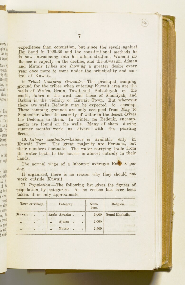
11. Population. —The following list gives the figures of
population by categories. As no census has ever been
taken, it is only approximate.
Town or village.
Category.
, Num
bers.
Religion.
Kuwait
Arabs Awazim .
3,000
Snnni Uanhalia.
*t • •
„ Ajman .
2,000
"
„ Mnteir ,
2,500
About this item
- Content
This volume contains geographical information and maps about the Arabian States of the Persian Gulf The historical term used to describe the body of water between the Arabian Peninsula and Iran. . It was produced by the General Staff, India, and printed by the Manager, Government of India Press, Simla, 1940.
The volume is divided into two sections: 'Military Report' including general descriptions of Kuwait, Bahrein, Hasa, Qatar, the Trucial Coast A name used by Britain from the nineteenth century to 1971 to refer to the present-day United Arab Emirates. , Muscat and Oman (folios 6-127) and 'Routes' (folios 128-164) including maps of:
- The Arabian States of the Persian Gulf The historical term used to describe the body of water between the Arabian Peninsula and Iran. , Muscat and Oman, and Routes in the area (f 158);
- Kuwait Area (f 159);
- Bahrein, Hasa and Qatar (f 160);
- Trucial Oman A name used by Britain from the nineteenth century to 1971 to refer to the present-day United Arab Emirates. (f 161);
- Muscat and Oman (f 162);
and sketches of:
- Bahrein Oil Company's area and important places (f 163);
- Sharjah and Dibai [Dubai] (f 158).
- Extent and format
- 1 volume (157 folios and 7 maps in pocket)
- Physical characteristics
There is a foliation sequence, which is circled in pencil, in the top right corner of the recto The front of a sheet of paper or leaf, often abbreviated to 'r'. of each folio. It begins on the front cover, on number 1, and ends on the last of several maps which are stored in a pocket at the back of the volume, on number 164.
- Written in
- English in Latin script View the complete information for this record
Use and share this item
- Share this item
'Military Report and Route Book. The Arabian States of the Persian Gulf. 1939' [14r] (27/328), British Library: India Office Records and Private Papers, IOR/L/PS/20/C252, in Qatar Digital Library <https://www.qdl.qa/archive/81055/vdc_100023722174.0x00001d> [accessed 24 April 2024]
https://www.qdl.qa/en/archive/81055/vdc_100023722174.0x00001d
Copy and paste the code below into your web page where you would like to embed the image.
<meta charset="utf-8"><a href="https://www.qdl.qa/en/archive/81055/vdc_100023722174.0x00001d">'Military Report and Route Book. The Arabian States of the Persian Gulf. 1939' [‎14r] (27/328)</a> <a href="https://www.qdl.qa/en/archive/81055/vdc_100023722174.0x00001d"> <img src="https://iiif.qdl.qa/iiif/images/81055/vdc_100000000884.0x0001da/IOR_L_PS_20_C252_0028.jp2/full/!280,240/0/default.jpg" alt="" /> </a>
This record has a IIIF manifest available as follows. If you have a compatible viewer you can drag the icon to load it.https://www.qdl.qa/en/iiif/81055/vdc_100000000884.0x0001da/manifestOpen in Universal viewerOpen in Mirador viewerMore options for embedding images
Copyright: How to use this content
- Reference
- IOR/L/PS/20/C252
- Title
- 'Military Report and Route Book. The Arabian States of the Persian Gulf. 1939'
- Pages
- front, front-i, 2r:156v, 158r:164v, back-i, back
- Author
- East India Company, the Board of Control, the India Office, or other British Government Department
- Usage terms
- Open Government Licence