!['Military Report and Route Book. The Arabian States of the Persian Gulf. 1939' [‎39v] (78/328)](https://iiif.qdl.qa/iiif/images/81055/vdc_100000000884.0x0001da/IOR_L_PS_20_C252_0079.jp2/full/!1200,1200/0/default.jpg "'Military Report and Route Book. The Arabian States of the Persian Gulf. 1939' [‎39v] (78/328)")
'Military Report and Route Book. The Arabian States of the Persian Gulf. 1939' [39v] (78/328)
The record is made up of 1 volume (157 folios and 7 maps in pocket). It was created in 1940. It was written in English. The original is part of the British Library: India Office The department of the British Government to which the Government of India reported between 1858 and 1947. The successor to the Court of Directors. Records and Private Papers Documents collected in a private capacity. .
Transcription
This transcription is created automatically. It may contain errors.
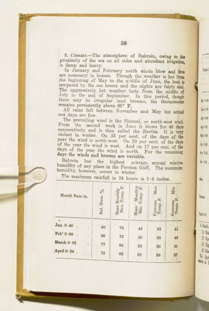
58
8, Climate. —The atmosphere of Bahrein, owing to the
proximity of the sea on all sides and abundant irrigation,
is damp and heavy.
In January and February north winds blow and fires
are necessary in houses. Though the weather is hot from
the beginning of May to the middle of June, the heat is
tempered by the sea breeze and the nights are fairly cool.
The oppressively hot weather lasts from the middle of
July to the end of September. In this period, though
there may be irregular land breezes, the thermometer
remains persistently above 95° F.
All rams fall between November and May but actual
wet days are few.
The prevailing wind is the Shamal, or north-west wind.
om the second week in June it blows for 40 days
consecutively and is then called the Bariha. It is very
violent in winter. On 33 per cent, of the days of the
year the wind is north-west. On 20 per cent, of the days
of the year the wind is west. And on 17 per cent, of the
, ys !■! . e y ear the wind is north. For the remaining
days the winds and breezes are variable.
„ ' ias _ highest average annual relative
any P^ ace
Persian Gulf
The historical term used to describe the body of water between the Arabian Peninsula and Iran.
, The maximum
Humidity, however, occurs in winter.
The maximum rainfall in 24 hours is 1-6 inches.
Month Rain in.
Jan.0'40
Feb'0-68 ,
March 0 • 52
April 0-24 ,
02
-a i
c a
o ®
a x
eS ^
a P-(
^ S
ce -a
S O h
s a
4)
X H
a
§
i ^
I a
« £
80
80
77
72
76
75
84
93
48
50
63
61
83
83
95
98
41
45
51
57
About this item
- Content
This volume contains geographical information and maps about the Arabian States of the Persian Gulf The historical term used to describe the body of water between the Arabian Peninsula and Iran. . It was produced by the General Staff, India, and printed by the Manager, Government of India Press, Simla, 1940.
The volume is divided into two sections: 'Military Report' including general descriptions of Kuwait, Bahrein, Hasa, Qatar, the Trucial Coast A name used by Britain from the nineteenth century to 1971 to refer to the present-day United Arab Emirates. , Muscat and Oman (folios 6-127) and 'Routes' (folios 128-164) including maps of:
- The Arabian States of the Persian Gulf The historical term used to describe the body of water between the Arabian Peninsula and Iran. , Muscat and Oman, and Routes in the area (f 158);
- Kuwait Area (f 159);
- Bahrein, Hasa and Qatar (f 160);
- Trucial Oman A name used by Britain from the nineteenth century to 1971 to refer to the present-day United Arab Emirates. (f 161);
- Muscat and Oman (f 162);
and sketches of:
- Bahrein Oil Company's area and important places (f 163);
- Sharjah and Dibai [Dubai] (f 158).
- Extent and format
- 1 volume (157 folios and 7 maps in pocket)
- Physical characteristics
There is a foliation sequence, which is circled in pencil, in the top right corner of the recto The front of a sheet of paper or leaf, often abbreviated to 'r'. of each folio. It begins on the front cover, on number 1, and ends on the last of several maps which are stored in a pocket at the back of the volume, on number 164.
- Written in
- English in Latin script View the complete information for this record
Use and share this item
- Share this item
'Military Report and Route Book. The Arabian States of the Persian Gulf. 1939' [39v] (78/328), British Library: India Office Records and Private Papers, IOR/L/PS/20/C252, in Qatar Digital Library <https://www.qdl.qa/archive/81055/vdc_100023722174.0x000050> [accessed 19 April 2024]
https://www.qdl.qa/en/archive/81055/vdc_100023722174.0x000050
Copy and paste the code below into your web page where you would like to embed the image.
<meta charset="utf-8"><a href="https://www.qdl.qa/en/archive/81055/vdc_100023722174.0x000050">'Military Report and Route Book. The Arabian States of the Persian Gulf. 1939' [‎39v] (78/328)</a> <a href="https://www.qdl.qa/en/archive/81055/vdc_100023722174.0x000050"> <img src="https://iiif.qdl.qa/iiif/images/81055/vdc_100000000884.0x0001da/IOR_L_PS_20_C252_0079.jp2/full/!280,240/0/default.jpg" alt="" /> </a>
This record has a IIIF manifest available as follows. If you have a compatible viewer you can drag the icon to load it.https://www.qdl.qa/en/iiif/81055/vdc_100000000884.0x0001da/manifestOpen in Universal viewerOpen in Mirador viewerMore options for embedding images
Copyright: How to use this content
- Reference
- IOR/L/PS/20/C252
- Title
- 'Military Report and Route Book. The Arabian States of the Persian Gulf. 1939'
- Pages
- front, front-i, 2r:156v, 158r:164v, back-i, back
- Author
- East India Company, the Board of Control, the India Office, or other British Government Department
- Usage terms
- Open Government Licence