!['Military Report and Route Book. The Arabian States of the Persian Gulf. 1939' [‎107r] (213/328)](https://iiif.qdl.qa/iiif/images/81055/vdc_100000000884.0x0001da/IOR_L_PS_20_C252_0214.jp2/full/!1200,1200/0/default.jpg "'Military Report and Route Book. The Arabian States of the Persian Gulf. 1939' [‎107r] (213/328)")
'Military Report and Route Book. The Arabian States of the Persian Gulf. 1939' [107r] (213/328)
The record is made up of 1 volume (157 folios and 7 maps in pocket). It was created in 1940. It was written in English. The original is part of the British Library: India Office The department of the British Government to which the Government of India reported between 1858 and 1947. The successor to the Court of Directors. Records and Private Papers Documents collected in a private capacity. .
Transcription
This transcription is created automatically. It may contain errors.
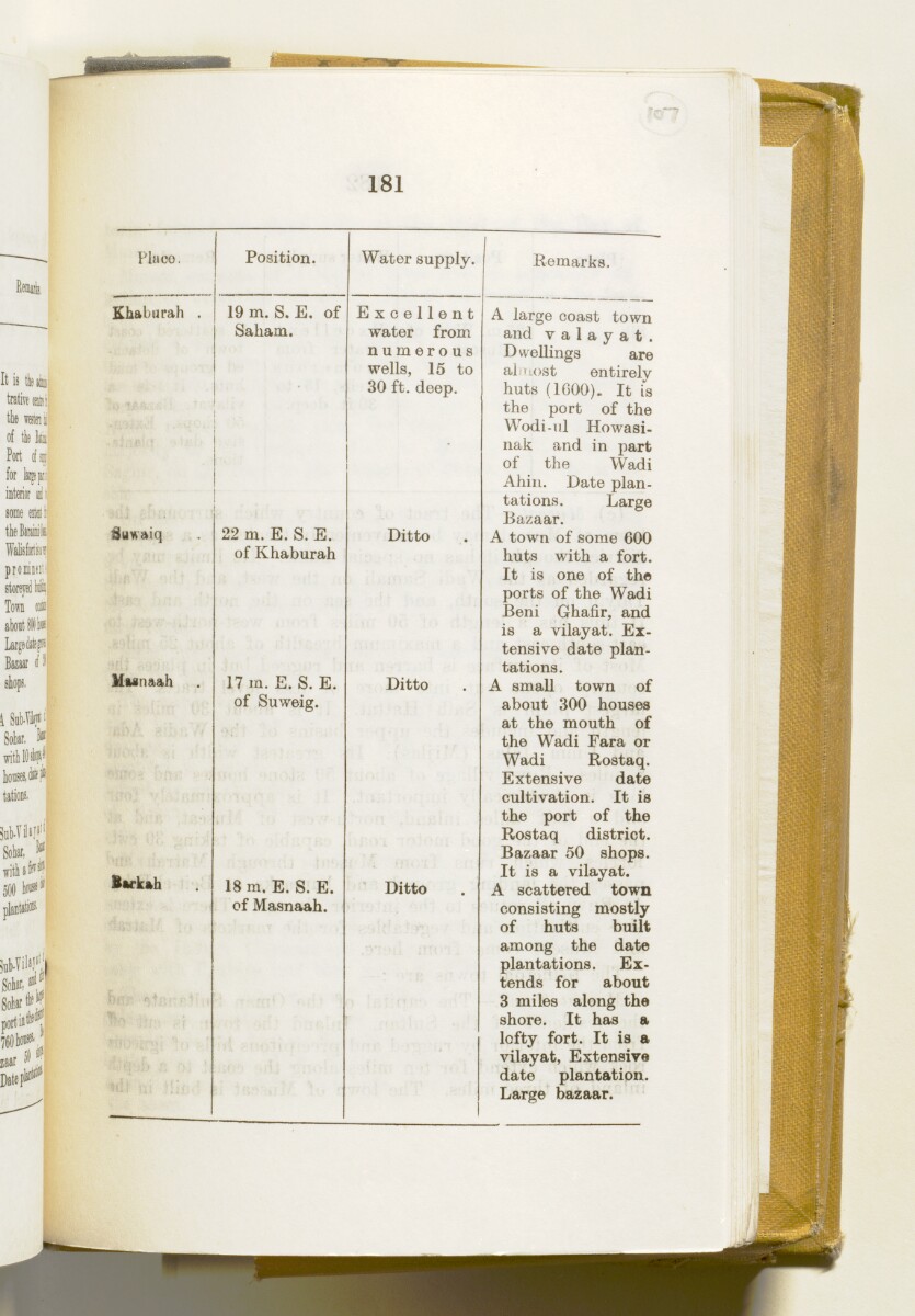
181
Place.
Position.
Water supply.
Remarks.
Khaburah .
19 m. S. E. of
Excellent
A large coast town
Saham.
water from
numerous
wells, 15 to
30 ft. deep.
and v a 1 a y a t .
Dwellings are
almost entirely
huts (1G00). It is
the port of the
Wodi-id Howasi-
nak and in part
of the
Wadi
A seasonal or intermittent watercourse, or the valley in which it flows.
Ahin. Date plan
tations. Large
Bazaar.
Suwaiq
22 m. E. S. E.
of Khaburah
Ditto
A town of some 600
huts with a fort.
It is one of the
ports of the
Wadi
A seasonal or intermittent watercourse, or the valley in which it flows.
Beni Ghafir, and
is a vilayat. Ex
tensive date plan
Munaah
tations.
17 m. E. S. E.
of Suvveig.
Ditto
A small town of
about 300 houses
at the mouth of
the
Wadi
A seasonal or intermittent watercourse, or the valley in which it flows.
Fara or
Wadi
A seasonal or intermittent watercourse, or the valley in which it flows.
Rostaq.
Extensive date
cultivation. It is
the port of the
Rostaq district.
Bazaar 50 shops.
Bukfth
It is a vilayat.
18 m. E. S. E,
of Masnaah.
Ditto
A scattered town
consisting mostly
of huts built
among the date
plantations. Ex
tends for about
3 miles along the
shore. It has a
lofty fort. It is a
vilayat, Extensive
date plantation.
Large bazaar.
About this item
- Content
This volume contains geographical information and maps about the Arabian States of the Persian Gulf The historical term used to describe the body of water between the Arabian Peninsula and Iran. . It was produced by the General Staff, India, and printed by the Manager, Government of India Press, Simla, 1940.
The volume is divided into two sections: 'Military Report' including general descriptions of Kuwait, Bahrein, Hasa, Qatar, the Trucial Coast A name used by Britain from the nineteenth century to 1971 to refer to the present-day United Arab Emirates. , Muscat and Oman (folios 6-127) and 'Routes' (folios 128-164) including maps of:
- The Arabian States of the Persian Gulf The historical term used to describe the body of water between the Arabian Peninsula and Iran. , Muscat and Oman, and Routes in the area (f 158);
- Kuwait Area (f 159);
- Bahrein, Hasa and Qatar (f 160);
- Trucial Oman A name used by Britain from the nineteenth century to 1971 to refer to the present-day United Arab Emirates. (f 161);
- Muscat and Oman (f 162);
and sketches of:
- Bahrein Oil Company's area and important places (f 163);
- Sharjah and Dibai [Dubai] (f 158).
- Extent and format
- 1 volume (157 folios and 7 maps in pocket)
- Physical characteristics
There is a foliation sequence, which is circled in pencil, in the top right corner of the recto The front of a sheet of paper or leaf, often abbreviated to 'r'. of each folio. It begins on the front cover, on number 1, and ends on the last of several maps which are stored in a pocket at the back of the volume, on number 164.
- Written in
- English in Latin script View the complete information for this record
Use and share this item
- Share this item
'Military Report and Route Book. The Arabian States of the Persian Gulf. 1939' [107r] (213/328), British Library: India Office Records and Private Papers, IOR/L/PS/20/C252, in Qatar Digital Library <https://www.qdl.qa/archive/81055/vdc_100023722175.0x00000f> [accessed 20 April 2024]
https://www.qdl.qa/en/archive/81055/vdc_100023722175.0x00000f
Copy and paste the code below into your web page where you would like to embed the image.
<meta charset="utf-8"><a href="https://www.qdl.qa/en/archive/81055/vdc_100023722175.0x00000f">'Military Report and Route Book. The Arabian States of the Persian Gulf. 1939' [‎107r] (213/328)</a> <a href="https://www.qdl.qa/en/archive/81055/vdc_100023722175.0x00000f"> <img src="https://iiif.qdl.qa/iiif/images/81055/vdc_100000000884.0x0001da/IOR_L_PS_20_C252_0214.jp2/full/!280,240/0/default.jpg" alt="" /> </a>
This record has a IIIF manifest available as follows. If you have a compatible viewer you can drag the icon to load it.https://www.qdl.qa/en/iiif/81055/vdc_100000000884.0x0001da/manifestOpen in Universal viewerOpen in Mirador viewerMore options for embedding images
Copyright: How to use this content
- Reference
- IOR/L/PS/20/C252
- Title
- 'Military Report and Route Book. The Arabian States of the Persian Gulf. 1939'
- Pages
- front, front-i, 2r:156v, 158r:164v, back-i, back
- Author
- East India Company, the Board of Control, the India Office, or other British Government Department
- Usage terms
- Open Government Licence