!['Military Report and Route Book. The Arabian States of the Persian Gulf. 1939' [‎137v] (274/328)](https://iiif.qdl.qa/iiif/images/81055/vdc_100000000884.0x0001da/IOR_L_PS_20_C252_0273.jp2/full/!1200,1200/0/default.jpg "'Military Report and Route Book. The Arabian States of the Persian Gulf. 1939' [‎137v] (274/328)")
'Military Report and Route Book. The Arabian States of the Persian Gulf. 1939' [137v] (274/328)
The record is made up of 1 volume (157 folios and 7 maps in pocket). It was created in 1940. It was written in English. The original is part of the British Library: India Office The department of the British Government to which the Government of India reported between 1858 and 1947. The successor to the Court of Directors. Records and Private Papers Documents collected in a private capacity. .
Transcription
This transcription is created automatically. It may contain errors.
■ r
BSMSKni^Sj
HHMH
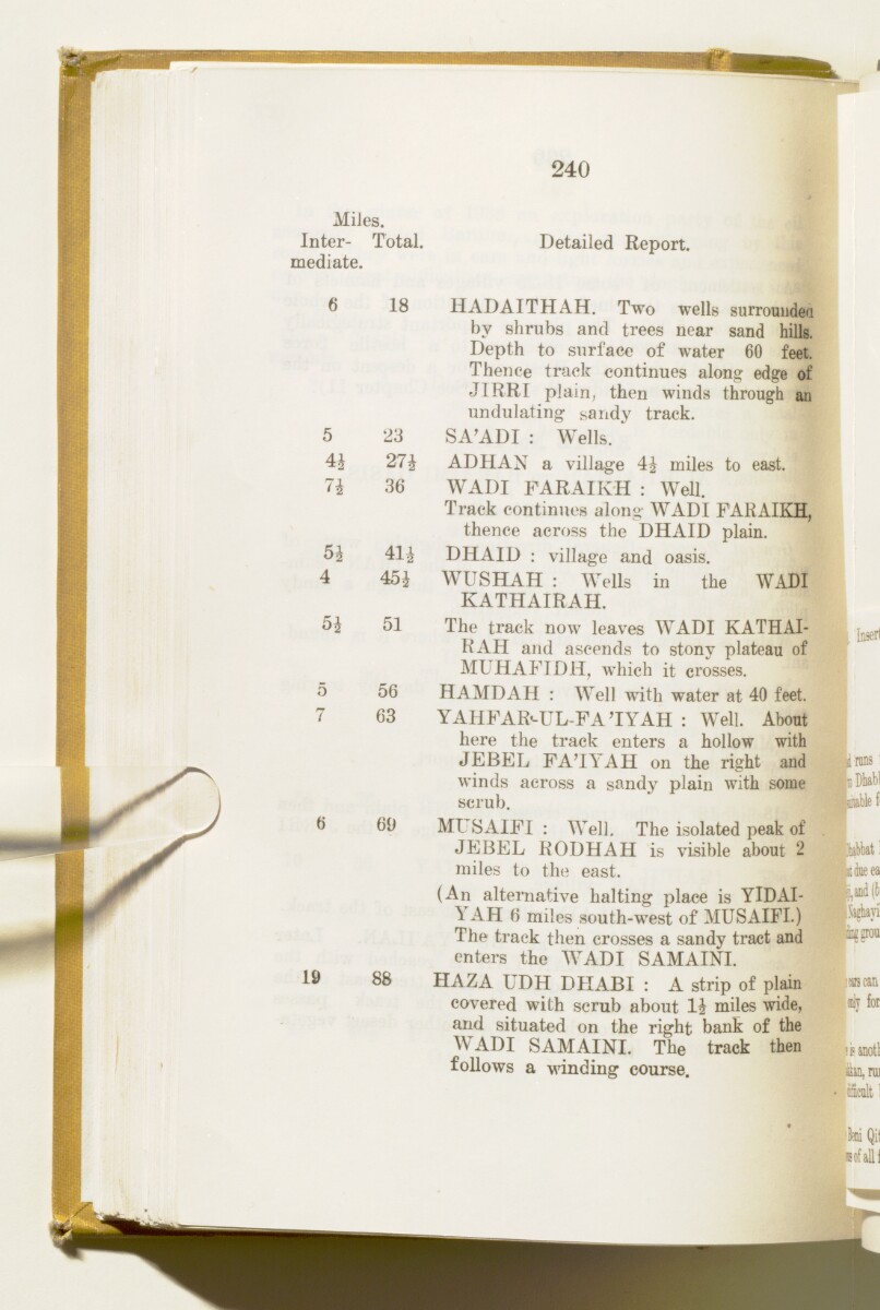
240
MiJes.
Inter- Total,
mediate.
Detailed Report.
6 18 HADAITHAH. Two wells surrounded
by shrubs and trees near sand hills.
Depth to surface of water 60 feet.
Thence track continues along edge of
JIRRI plain, then winds through an
undulating sandy track.
SA'ADI : Wells.
ADHAN a village 4^ miles to east.
WADI
A seasonal or intermittent watercourse, or the valley in which it flows.
FARAIKH : Well.
Track continues along
WADI
A seasonal or intermittent watercourse, or the valley in which it flows.
FARAIKH,
thence across the DHAID plain.
DHAID : village and oasis.
WUSHAH : Wells in the
WADI
A seasonal or intermittent watercourse, or the valley in which it flows.
KATHAIRAH.
The track now leaves
WADI
A seasonal or intermittent watercourse, or the valley in which it flows.
KATHAI
RAH and ascends to stony plateau of
MUHAFIDH, which it crosses.
H AMD AH : Well with water at 40 feet.
YAHFAR<-UL-FA 'IYAH : Well. About
here the track enters a hollow with
JEBEL FA'IYAH on the right and
winds across a sandy plain with some
scrub.
Ml SAIFI : Well, The isolated peak of
JEBEL RODHAH is visible about 2
miles to the east.
(An alternative halting place is YlDAI-
^ AH 6 miles south-west of MUSAIFI.)
The track then crosses a sandy tract and
enters the
WADI
A seasonal or intermittent watercourse, or the valley in which it flows.
SAMAINI.
19 88 HAZA UDH DHABI : A strip of plain
covered with scrub about li miles wide,
and situated on the right bank of the
WADI
A seasonal or intermittent watercourse, or the valley in which it flows.
SAMAINI. The track then
follows a winding course.
5
4i
7i
5^
4
5*
23
27J
36
41i
45 J
51
56
63
69
luserl
(dy for
■isanotl
San, mi
iiScolt;
About this item
- Content
This volume contains geographical information and maps about the Arabian States of the Persian Gulf The historical term used to describe the body of water between the Arabian Peninsula and Iran. . It was produced by the General Staff, India, and printed by the Manager, Government of India Press, Simla, 1940.
The volume is divided into two sections: 'Military Report' including general descriptions of Kuwait, Bahrein, Hasa, Qatar, the Trucial Coast A name used by Britain from the nineteenth century to 1971 to refer to the present-day United Arab Emirates. , Muscat and Oman (folios 6-127) and 'Routes' (folios 128-164) including maps of:
- The Arabian States of the Persian Gulf The historical term used to describe the body of water between the Arabian Peninsula and Iran. , Muscat and Oman, and Routes in the area (f 158);
- Kuwait Area (f 159);
- Bahrein, Hasa and Qatar (f 160);
- Trucial Oman A name used by Britain from the nineteenth century to 1971 to refer to the present-day United Arab Emirates. (f 161);
- Muscat and Oman (f 162);
and sketches of:
- Bahrein Oil Company's area and important places (f 163);
- Sharjah and Dibai [Dubai] (f 158).
- Extent and format
- 1 volume (157 folios and 7 maps in pocket)
- Physical characteristics
There is a foliation sequence, which is circled in pencil, in the top right corner of the recto The front of a sheet of paper or leaf, often abbreviated to 'r'. of each folio. It begins on the front cover, on number 1, and ends on the last of several maps which are stored in a pocket at the back of the volume, on number 164.
- Written in
- English in Latin script View the complete information for this record
Use and share this item
- Share this item
'Military Report and Route Book. The Arabian States of the Persian Gulf. 1939' [137v] (274/328), British Library: India Office Records and Private Papers, IOR/L/PS/20/C252, in Qatar Digital Library <https://www.qdl.qa/archive/81055/vdc_100023722175.0x00004a> [accessed 25 April 2024]
https://www.qdl.qa/en/archive/81055/vdc_100023722175.0x00004a
Copy and paste the code below into your web page where you would like to embed the image.
<meta charset="utf-8"><a href="https://www.qdl.qa/en/archive/81055/vdc_100023722175.0x00004a">'Military Report and Route Book. The Arabian States of the Persian Gulf. 1939' [‎137v] (274/328)</a> <a href="https://www.qdl.qa/en/archive/81055/vdc_100023722175.0x00004a"> <img src="https://iiif.qdl.qa/iiif/images/81055/vdc_100000000884.0x0001da/IOR_L_PS_20_C252_0273.jp2/full/!280,240/0/default.jpg" alt="" /> </a>
This record has a IIIF manifest available as follows. If you have a compatible viewer you can drag the icon to load it.https://www.qdl.qa/en/iiif/81055/vdc_100000000884.0x0001da/manifestOpen in Universal viewerOpen in Mirador viewerMore options for embedding images
Copyright: How to use this content
- Reference
- IOR/L/PS/20/C252
- Title
- 'Military Report and Route Book. The Arabian States of the Persian Gulf. 1939'
- Pages
- front, front-i, 2r:156v, 158r:164v, back-i, back
- Author
- East India Company, the Board of Control, the India Office, or other British Government Department
- Usage terms
- Open Government Licence