![‘MAP TO SHOW THE LIMITS OF KOWEIT AND ADJACENT COUNTRY. Annexe V’ [‎125r] (1/2)](https://iiif.qdl.qa/iiif/images/81055/vdc_100000000193.0x00024a/IOR_R_15_1_613_0269.jp2/full/!1200,1200/0/default.jpg "‘MAP TO SHOW THE LIMITS OF KOWEIT AND ADJACENT COUNTRY. Annexe V’ [‎125r] (1/2)")
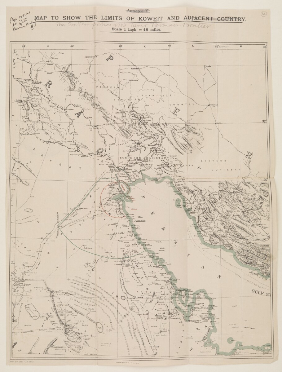
‘MAP TO SHOW THE LIMITS OF KOWEIT AND ADJACENT COUNTRY. Annexe V’ [125r] (1/2)
The record is made up of 1 map. It was created in 1913. It was written in English. The original is part of the British Library: India Office The department of the British Government to which the Government of India reported between 1858 and 1947. The successor to the Court of Directors. Records and Private Papers Documents collected in a private capacity. .
About this item
- Content
Imprint:
Harrison & Sons Lith. St. Martins Lane, W.C.
Distinctive Features:
Relief shown by hachures. Limits indicated by red and green lines. Bottom left hand corner below neat line: '(1000. 5/13. 2567) F.O. 1370'.
Other copies of this map hold at folio 25 and folio 294. Inscriptions:
Top left-hand corner, in black ink: ‘(Page 148.(a) file 73/7 III. Residency An office of the East India Company and, later, of the British Raj, established in the provinces and regions considered part of, or under the influence of, British India. Bushire) [initials]'.
Upper centre: ‘Annexe V’ and ‘ADJACENT COUNTRY’ in title crossed out with pencil and annotation ‘The Southern portion of the Turco-Persian frontier’ inserted below title.
- Extent and format
- 1 map
- Area map covers
- Map loading...
- Scale
- Scale approximately 1:3,000,000
- Scale designator
- Horizontal
- Orientation
- North
- Degree coordinates
- Top-left: 34° 55' 21.72" N, 43° 35' 4.92" E
Top-right: 34° 55' 21.72" N, 54° 1' 53.4" E
Bottom-left: 23° 54' 53.28" N, 43° 35' 4.92" E
Bottom-right: 23° 54' 53.28" N, 54° 1' 53.4" E - Physical characteristics
Dimensions: 392 x 320 mm, on sheet 446 x 335 mm
- Written in
- English in Latin script View the complete information for this record
Use and share this item
- Share this item
‘MAP TO SHOW THE LIMITS OF KOWEIT AND ADJACENT COUNTRY. Annexe V’ [125r] (1/2), British Library: India Office Records and Private Papers, IOR/R/15/1/613, f 125, in Qatar Digital Library <https://www.qdl.qa/archive/81055/vdc_100023726565.0x00003a> [accessed 17 April 2024]
https://www.qdl.qa/en/archive/81055/vdc_100023726565.0x00003a
Copy and paste the code below into your web page where you would like to embed the image.
<meta charset="utf-8"><a href="https://www.qdl.qa/en/archive/81055/vdc_100023726565.0x00003a">‘MAP TO SHOW THE LIMITS OF KOWEIT AND ADJACENT COUNTRY. Annexe V’ [‎125r] (1/2)</a> <a href="https://www.qdl.qa/en/archive/81055/vdc_100023726565.0x00003a"> <img src="https://iiif.qdl.qa/iiif/images/81055/vdc_100000000193.0x00024a/IOR_R_15_1_613_0269.jp2/full/!280,240/0/default.jpg" alt="" /> </a>
This record has a IIIF manifest available as follows. If you have a compatible viewer you can drag the icon to load it.https://www.qdl.qa/en/iiif/81055/vdc_100000000193.0x00024a/manifestOpen in Universal viewerOpen in Mirador viewerMore options for embedding images
Copyright: How to use this content
- Reference
- IOR/R/15/1/613, f 125
- Title
- ‘MAP TO SHOW THE LIMITS OF KOWEIT AND ADJACENT COUNTRY. Annexe V’
- Pages
- 125r:125v
- Author
- Harrison and Sons Ltd
- Usage terms
- Public Domain