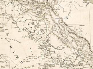
‘Plan 1. Mesopotamia’
IOR/L/MIL/17/15/73, p 119

1 items in this record
Search within this record
The record is made up of 1 map. It was created in 1921. It was written in English. The original is part of the British Library: India Office The department of the British Government to which the Government of India reported between 1858 and 1947. The successor to the Court of Directors. Records and Private Papers Documents collected in a private capacity. .
About this record
- Content
Imprint:
Ordnance Survey, 1921.
Distinctive Features:
Relief shown by hachures.
General map of Southern Mesopotamia from Baghdad down to the Persian Gulf The historical term used to describe the body of water between the Arabian Peninsula and Iran. with Turco-Persian frontier indicated by dash-dot line, and areas liable to inundation, marshes and channels, including a new channel between Suk as Shayuk and Basra marked.
- Extent and format
- 1 map
- Area map covers
- Map loading...
- Scale
- Scale not given
- Scale designator
- Horizontal
- Orientation
- North
- Degree coordinates
- Top-left: 33° 35' 57.12" N, 43° 21' 50.76" E
Top-right: 33° 35' 57.12" N, 49° 0' 57.96" E
Bottom-left: 29° 12' 35.64" N, 43° 21' 50.76" E
Bottom-right: 29° 12' 35.64" N, 49° 0' 57.96" E - It is part of
- 150 imagesRef: IOR/L/MIL/17/15/73
- Physical characteristics
Dimensions: 205 x 272 mm, on sheet 245 x 331 mm
- Written in
- English in Latin script
- Type
- Map
Archive information for this record
- Original held at
- British Library: India Office The department of the British Government to which the Government of India reported between 1858 and 1947. The successor to the Court of Directors. Records and Private Papers Documents collected in a private capacity.
- Access conditions
Unrestricted
- Archive reference
- IOR/L/MIL/17/15/73, p 119
- Date(s)
- 1921 (CE, Gregorian)
Access & Reference
History of this record
Related search terms
- Places
- Mesopotamia
Use and share this record
- Share this record
- Cite this record in your research
‘Plan 1. Mesopotamia’, British Library: India Office Records and Private Papers, IOR/L/MIL/17/15/73, p 119, in Qatar Digital Library <https://www.qdl.qa/archive/81055/vdc_100023824113.0x000008> [accessed 23 April 2024]
- Link to this record
https://www.qdl.qa/en/archive/81055/vdc_100023824113.0x000008
- IIIF details
This record has a IIIF manifest available as follows. If you have a compatible viewer you can drag the icon to load it.https://www.qdl.qa/en/iiif/81055/vdc_100000000239.0x00018d/manifestOpen in Universal viewerOpen in Mirador viewerMore options for embedding images
Copyright: How to use this content
- Reference
- IOR/L/MIL/17/15/73, p 119
- Title
- ‘Plan 1. Mesopotamia’
- Pages
- 119
- Author
- Ordnance Survey
- Usage terms
- Public Domain