![‘A Trigonometrical Survey of Socotra by Lieut.ts S.B. Haines and I.R. Wellsted assisted by Lieut. I.P. Sanders and Mess.rs Rennie Cruttenden & Fleming Mids.n, Indian Navy. Engraved by R. Bateman, 72 Long Acre’ [‎8r] (1/2)](https://iiif.qdl.qa/iiif/images/81055/vdc_100022840540.0x000001/IOR_X_3630_0015.jp2/full/!1200,1200/0/default.jpg "‘A Trigonometrical Survey of Socotra by Lieut.ts S.B. Haines and I.R. Wellsted assisted by Lieut. I.P. Sanders and Mess.rs Rennie Cruttenden & Fleming Mids.n, Indian Navy. Engraved by R. Bateman, 72 Long Acre’ [‎8r] (1/2)")
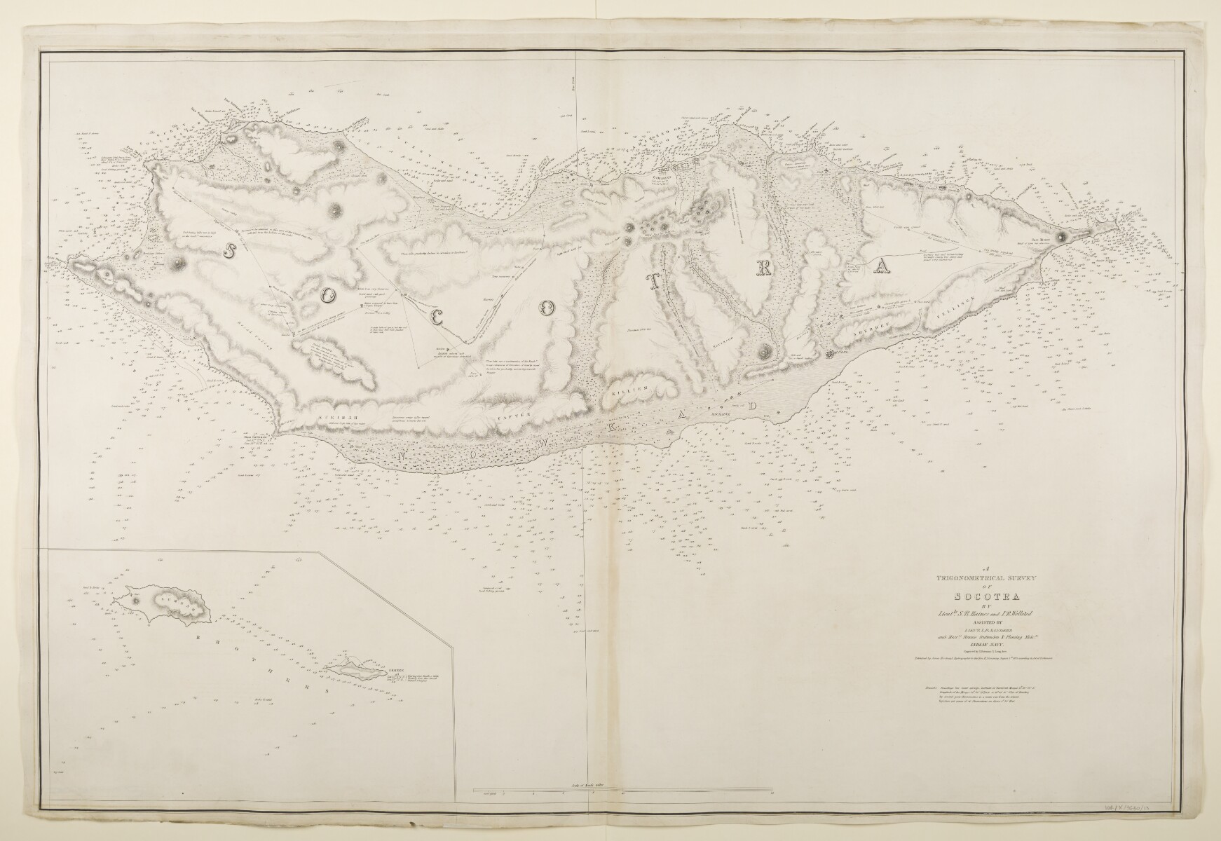
‘A Trigonometrical Survey of Socotra by Lieut.ts S.B. Haines and I.R. Wellsted assisted by Lieut. I.P. Sanders and Mess.rs Rennie Cruttenden & Fleming Mids.n, Indian Navy. Engraved by R. Bateman, 72 Long Acre’ [8r] (1/2)
The record is made up of 1 map. It was created in 1 Aug 1835. It was written in English. The original is part of the British Library: Map Collections.
About this item
- Content
Imprint:
Published by James Horsburgh, Hydrographer to the Honourable East India Company.
Distinctive Features:
Relief shown by hachures. Depths shown by soundings Measurements of the depth of a body of water. .
Nautical chart of the Socotra Island compiled from the surveys carried out by the Bombay Marine’s officers between 1820 and 1829 with an inset A small map or other image enclosed within the margin of a larger map, map sheet, or larger image; or papers placed inside a book or archival volume. map showing Samhah and Darsah Islands.
Numerous notations concerning terrain features and vegetation cover the face of the map with routes, the approximate location of ‘Bedouin caves’, and coordinates of settlements reported.
Contains a note with remarks on latitude and longitude variation and water level observations.
- Extent and format
- 1 map
- Area map covers
- Map loading...
- Scale
- Scale approximately 1:62,500
- Scale designator
- Horizontal
- Orientation
- North
- Degree coordinates
- Top-left: 12° 50' 6.86" N, 52° 54' 44.52" E
Top-right: 12° 50' 6.86" N, 54° 33' 54.01" E
Bottom-left: 12° 2' 0.06" N, 52° 54' 44.52" E
Bottom-right: 12° 2' 0.06" N, 54° 33' 54.01" E - Physical characteristics
Dimensions: 626 x 968 mm, on sheet 682 x 1001 mm
- Written in
- English in Latin script View the complete information for this record
Use and share this item
- Share this item
‘A Trigonometrical Survey of Socotra by Lieut.ts S.B. Haines and I.R. Wellsted assisted by Lieut. I.P. Sanders and Mess.rs Rennie Cruttenden & Fleming Mids.n, Indian Navy. Engraved by R. Bateman, 72 Long Acre’ [8r] (1/2), British Library: Map Collections, IOR/X/3630/13, in Qatar Digital Library <https://www.qdl.qa/archive/81055/vdc_100023868004.0x000010> [accessed 19 April 2024]
https://www.qdl.qa/en/archive/81055/vdc_100023868004.0x000010
Copy and paste the code below into your web page where you would like to embed the image.
<meta charset="utf-8"><a href="https://www.qdl.qa/en/archive/81055/vdc_100023868004.0x000010">‘A Trigonometrical Survey of Socotra by Lieut.ts S.B. Haines and I.R. Wellsted assisted by Lieut. I.P. Sanders and Mess.rs Rennie Cruttenden & Fleming Mids.n, Indian Navy. Engraved by R. Bateman, 72 Long Acre’ [‎8r] (1/2)</a> <a href="https://www.qdl.qa/en/archive/81055/vdc_100023868004.0x000010"> <img src="https://iiif.qdl.qa/iiif/images/81055/vdc_100022840540.0x000001/IOR_X_3630_0015.jp2/full/!280,240/0/default.jpg" alt="" /> </a>
This record has a IIIF manifest available as follows. If you have a compatible viewer you can drag the icon to load it.https://www.qdl.qa/en/iiif/81055/vdc_100022840540.0x000001/manifestOpen in Universal viewerOpen in Mirador viewerMore options for embedding images
Copyright: How to use this content
- Reference
- IOR/X/3630/13
- Title
- ‘A Trigonometrical Survey of Socotra by Lieut.ts S.B. Haines and I.R. Wellsted assisted by Lieut. I.P. Sanders and Mess.rs Rennie Cruttenden & Fleming Mids.n, Indian Navy. Engraved by R. Bateman, 72 Long Acre’
- Pages
- 8r:8v
- Author
- Please see item description
- Usage terms
- Public Domain