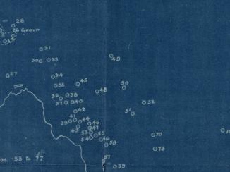
'Pocket No. 25: Enclosure to Part III of Volume I of the Persian Gulf Gazetteer: Chart showing the Pearl Banks along the Arabian Shore of the Persian Gulf between Ras Tanura and Debai'
IOR/L/PS/20/C91/3, f 27

2 items in this record
Search within this record
The record is made up of 1 map. It was created in 1915. It was written in English and Arabic. The original is part of the British Library: India Office The department of the British Government to which the Government of India reported between 1858 and 1947. The successor to the Court of Directors. Records and Private Papers Documents collected in a private capacity. .
About this record
- Content
Distinctive Features:
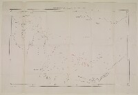
An outline map entitled 'Chart showing the Pearl Banks along Arabian Shore of the Persian Gulf The historical term used to describe the body of water between the Arabian Peninsula and Iran. between Ras Tanura and Dabai' issued as an enclosure to Part II of Volume I of the ‘Persian Gulf Gazetteer'. Shows the southern coast of the Persian Gulf The historical term used to describe the body of water between the Arabian Peninsula and Iran. between Ras Tanura and Dabai [Dubai] with the location of the pearl banks indicated. Each of the pearl banks is marked with a number.
Bottom left-hand corner below neat line: ‘Reg. No. 1605 E., 14.-V.-225’.
- Extent and format
- 1 map
- Area map covers
- Map loading...
- Scale
- Scale not given
- Scale designator
- Horizontal
- Orientation
- North
- Degree coordinates
- Top-left: 26° 53' 17.88" N, 49° 55' 33.96" E
Top-right: 26° 53' 17.88" N, 55° 12' 10.08" E
Bottom-left: 23° 53' 23.28" N, 49° 55' 33.96" E
Bottom-right: 23° 53' 23.28" N, 55° 12' 10.08" E - It is part of
- 94 imagesRef: IOR/L/PS/20/C91/3
- Physical characteristics
Dimensions: 361 x 585 mm, on sheet 457 x 683 mm
- Written in
- English and Arabic in Latin and Arabic script
- Type
- Map
Archive information for this record
- Original held at
- British Library: India Office The department of the British Government to which the Government of India reported between 1858 and 1947. The successor to the Court of Directors. Records and Private Papers Documents collected in a private capacity.
- Access conditions
Unrestricted
- Archive reference
- IOR/L/PS/20/C91/3, f 27
- Date(s)
- 1915 (CE, Gregorian)
Access & Reference
History of this record
Related search terms
- Subjects
- Pearl industry and trade
Use and share this record
- Share this record
- Cite this record in your research
'Pocket No. 25: Enclosure to Part III of Volume I of the Persian Gulf Gazetteer: Chart showing the Pearl Banks along the Arabian Shore of the Persian Gulf between Ras Tanura and Debai', British Library: India Office Records and Private Papers, IOR/L/PS/20/C91/3, f 27, in Qatar Digital Library <https://www.qdl.qa/archive/81055/vdc_100023876399.0x000001> [accessed 25 April 2024]
- Link to this record
https://www.qdl.qa/en/archive/81055/vdc_100023876399.0x000001
- IIIF details
This record has a IIIF manifest available as follows. If you have a compatible viewer you can drag the icon to load it.https://www.qdl.qa/en/iiif/81055/vdc_100000000884.0x00014a/manifestOpen in Universal viewerOpen in Mirador viewerMore options for embedding images
Copyright: How to use this content
- Reference
- IOR/L/PS/20/C91/3, f 27
- Title
- 'Pocket No. 25: Enclosure to Part III of Volume I of the Persian Gulf Gazetteer: Chart showing the Pearl Banks along the Arabian Shore of the Persian Gulf between Ras Tanura and Debai'
- Pages
- 27r:27v
- Author
- East India Company, the Board of Control, the India Office, or other British Government Department
- Usage terms
- Open Government Licence