!['ROUTES IN PERSIA. SECTION III' [‎114v] (233/739)](https://iiif.qdl.qa/iiif/images/81055/vdc_100000001491.0x000114/Mss Eur F111_371_0231.jp2/full/!1200,1200/0/default.jpg "'ROUTES IN PERSIA. SECTION III' [‎114v] (233/739)")
'ROUTES IN PERSIA. SECTION III' [114v] (233/739)
The record is made up of 1 volume (367 folios). It was created in 1898. It was written in English. The original is part of the British Library: India Office The department of the British Government to which the Government of India reported between 1858 and 1947. The successor to the Court of Directors. Records and Private Papers Documents collected in a private capacity. .
Transcription
This transcription is created automatically. It may contain errors.
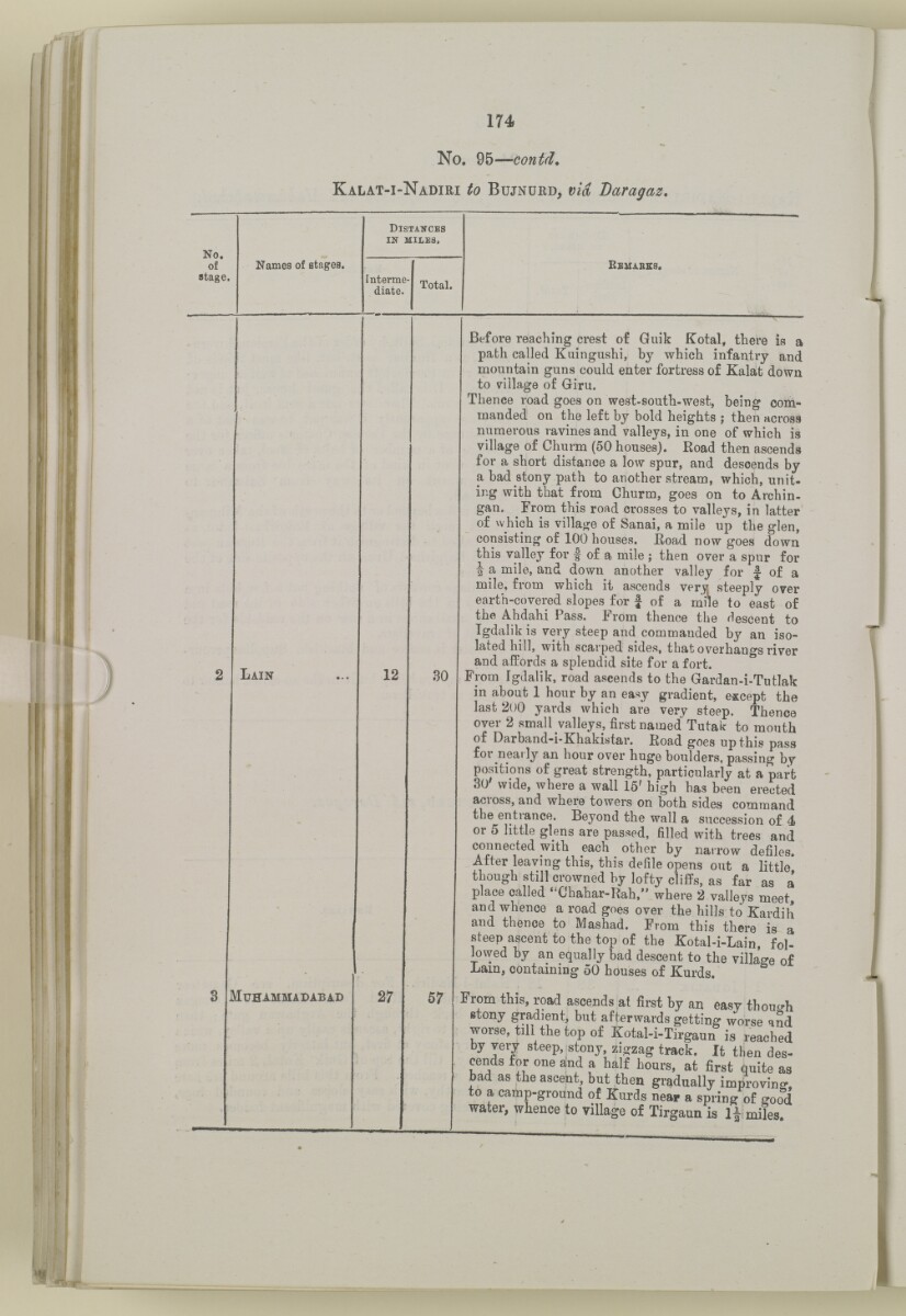
174
No. 95— contd.
K alat-i- N adiri to B ujnurd, via Daragaz.
No.
of
stage.
Names of stages.
D istances
in miles,
Interme'
diate.
Total.
K emabes.
Lain
12
30
Muhammadabad
27
57
Before reaching crest of Guik Kotal, there is a
path called Kuingushi, by which infantry and
mountain guns could enter fortress of Kalat down
to village of Giru.
Thence road goes on west-south-west, being com
manded on the left by bold heights ; then across
numerous ravines and valleys, in one of which is
village of Churm (50 houses). Road then ascends
for a short distance a low spur, and descends by
a bad stony path to another stream, which, unit
ing with that from Ohurm, goes on to Archin-
gan. From this road crosses to valleys, in latter
of which is village of Sanai, a mile up the glen,
consisting of 100 houses. Eoad now goes down
this valley for ^ of a mile ; then over a spur for
| a mile, and down another valley for f of a
mile, from which it ascends verv steeply over
earth-covered slopes for | of a mile to east of
the Ahdahi Pass. Prom thence the descent to
Tgdalik is very steep and commanded by an iso
lated hill, with scarped sides, that overhangs river
and affords a splendid site for a fort.
From Tgdalik, road ascends to the Gardan-i-Tutlak
in about 1 hour by an easy gradient, except the
last 200 yards which are very steep. Thence
over 2 small valleys, first named Tutak to mouth
of Darband-i-Khakistar. Road goes up this pass
for nearly an hour over huge boulders, passing by
positions of great strength, particularly at a part
30 wide, where a wall 15' high has been erected
across, and where towers on both sides command
the entrance. Beyond the wall a succession of 4
or 5 little glens are passed, filled with trees and
connected with each other by narrow defiles.
After leaving this, this defile opens out a little
though still crowned by lofty cliffs, as far as a
place called ' Chahar-Rah," where 2 valleys meet
and whence a road goes over the hills to Kardih
and thence to Mashad. From this there is a
steep ascent to the top of the Kotal-i-Lain, fol
lowed by aii equally bad descent to the village of
Lam, containing 50 houses of Kurds.
From this, road ascends at first by an easy though
stony gradient, but afterwards getting worse qnd
worse, till the top of Kotal-i-Tn-gaun^r^ched
by very steep, stony, zigzag track. It then des-
cends for one and a half hours, at first quite as
bad as the ascent, but then gradually improvins.
to a camp-ground of Kurds near a spring of good
water, whence to village of Tirgaun is 1J miles.
About this item
- Content
The volume is a Government of India official publication entitled Routes in Persia. Section III. Compiled in the Intelligence Branch of the Quarter Master General's Department in India (Simla: printed at the Government Central Printing Office, 1898).
The volume contains details of all land routes (numbered 1-247) in Persia starting from Russian territory and extending south as far as a line drawn from Karmanshah [Kermānshāh] south-eastwards through Burujird [Borūjerd], Isfahan [Eşfahān] and Yazd to Karman [Kermān], and thence north-east to Khabis [Khabīş] and Neh to Lash Juwain [Lāsh-e Juwayn].
The information given for each route comprises:
- number of route;
- place names forming starting point and destination of route;
- authority and date;
- number of stage;
- names of stages;
- distance in miles (intermediate and total);
- remarks (including precise details of the route, general geographical information, and information on smaller settlements, local peoples, agriculture, condition of roads, access to water, supplies of wood, and other routes).
An appendix within the volume (folios 356-359) and two separately-stored sets of loose sheets (containing routes numbers 77 (a) and 140-A, folios 363-369) give information too late for incorporation in the body of the work.
The volume also contains pockets attached to the front and back inside covers for maps. These consist of an index map showing the limits of each of the three sections of Routes in Persia (folio 2) and an index map to the routes in Section III (folio 361). There is also a fold-out map of the route from Seistan [Sīstān] to Mashad on folio 232.
An ink stamp on the front cover records the confidential nature of the publication and that it was being transmitted for the information of His Excellency the Viceroy (Victor Alexander Bruce, 9th Earl of Elgin and 16th Earl of Kincardine) only.
- Extent and format
- 1 volume (367 folios)
- Arrangement
The volume contains an alphabetical cross index (folios 6-17), and an alphabetical index to names of places (folios 18-25).
- Physical characteristics
Foliation: the foliation sequence commences at the front cover and terminates on the last page of the loose supplementary sheets (found in the small grey folder within the main folder); these numbers are written in pencil, are circled, and are located in the top right corner of the recto The front of a sheet of paper or leaf, often abbreviated to 'r'. side of each folio.
Pagination: the volume also contains a printed pagination sequence.
- Written in
- English in Latin script View the complete information for this record
Use and share this item
- Share this item
'ROUTES IN PERSIA. SECTION III' [114v] (233/739), British Library: India Office Records and Private Papers, Mss Eur F111/371, in Qatar Digital Library <https://www.qdl.qa/archive/81055/vdc_100024054421.0x000020> [accessed 24 April 2024]
https://www.qdl.qa/en/archive/81055/vdc_100024054421.0x000020
Copy and paste the code below into your web page where you would like to embed the image.
<meta charset="utf-8"><a href="https://www.qdl.qa/en/archive/81055/vdc_100024054421.0x000020">'ROUTES IN PERSIA. SECTION III' [‎114v] (233/739)</a> <a href="https://www.qdl.qa/en/archive/81055/vdc_100024054421.0x000020"> <img src="https://iiif.qdl.qa/iiif/images/81055/vdc_100000001491.0x000114/Mss Eur F111_371_0231.jp2/full/!280,240/0/default.jpg" alt="" /> </a>
This record has a IIIF manifest available as follows. If you have a compatible viewer you can drag the icon to load it.https://www.qdl.qa/en/iiif/81055/vdc_100000001491.0x000114/manifestOpen in Universal viewerOpen in Mirador viewerMore options for embedding images
Copyright: How to use this content
- Reference
- Mss Eur F111/371
- Title
- 'ROUTES IN PERSIA. SECTION III'
- Pages
- front, back, spine, edge, head, tail, front-i, 2r:58r, 59r:232r, 232r:233r, 234r:361v, back-i, 363r:363v, 365r:369v
- Author
- East India Company, the Board of Control, the India Office, or other British Government Department
- Usage terms
- Open Government Licence