!['ROUTES IN PERSIA. SECTION III' [‎138v] (281/739)](https://iiif.qdl.qa/iiif/images/81055/vdc_100000001491.0x000114/Mss Eur F111_371_0279.jp2/full/!1200,1200/0/default.jpg "'ROUTES IN PERSIA. SECTION III' [‎138v] (281/739)")
'ROUTES IN PERSIA. SECTION III' [138v] (281/739)
The record is made up of 1 volume (367 folios). It was created in 1898. It was written in English. The original is part of the British Library: India Office The department of the British Government to which the Government of India reported between 1858 and 1947. The successor to the Court of Directors. Records and Private Papers Documents collected in a private capacity. .
Transcription
This transcription is created automatically. It may contain errors.
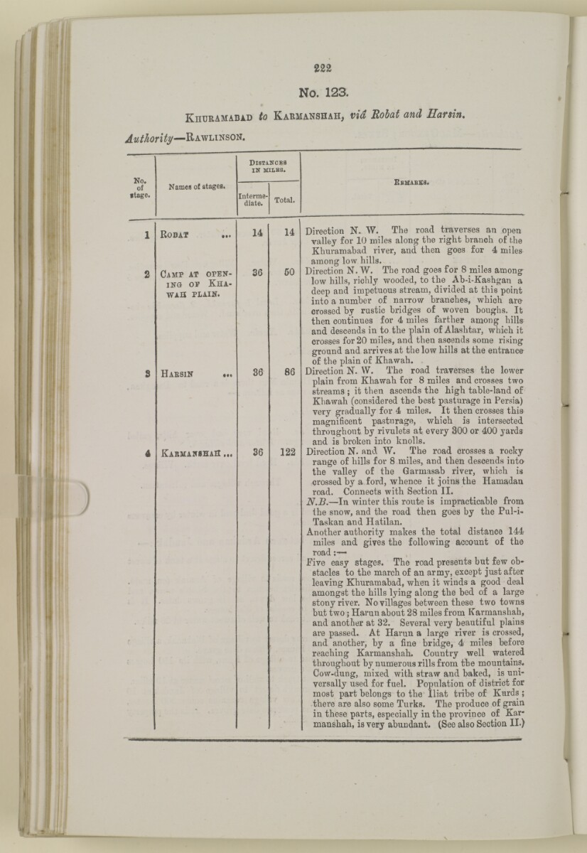
222
No. 123.
Kiiuramabid to Karmanshaii, via Ear sin.
Rawlinson.
dlstancea
in" MILBS.
No.
of
ftage.
K emabss.
Names of stages.
Interme
diate.
Total.
R obat
C amp at open
ing op K ha-
WAH plain.
H aesin
K armansha S >(
14
36
36
36
14
50
86
122
Direction N. W. The road traverses an open
valley for 10 miles along the right branch of the
Khnramabad river, and then goes for 4 miles
among low hills.
Direction N. W. The road goes for 8 miles among
low hills, richly wooded, to the Ab-i-Kashgan a
deep and impetuous stream, divided at this point
into a number of narrow branches, which are
crossed by rustic bridges of woven boughs. It
then continues for 4 miles farther among hills
and descends in to the plain of Alashtar, which it
crosses for 20 miles, and then ascends some rising
ground and arrives at the low hills at the entrance
of the plain of Khawah.
Direction N. W. The road traverses the lower
plain from Khawah for 8 miles and crosses two
streams ; it then ascends the high table-land of
Khawah (considered the best pasturage in Persia)
very gradually for 4 miles. It then crosses this
magnificent pasturage, which is intersected
throughout by rivulets at every 300 or 400 yards
and is broken into knolls.
Direction N. and W. The road crosses a rocky
range of hills for 8 miles, and then descends into
the valley of the Garmasab river, which is
crossed by a ford, whence it joins the Hamadau
road. Connects with Section II.
N.B. —In winter this route is impracticable from
the snow, and the road then goes by the Pul-i-
Taskan and Hatilan.
Another authority makes the total distance 144
miles and gives the following account of the
road
Five easy stages. The road presents but few ob
stacles to the march of an army, except just after
leaving Khuramabad, when it winds a good deal
amongst the hills lying along the bed of a large
stony river. No villages between these two towns
but two; Harun about 28 miles from Karmanshah,
and another at 32. Several very beautiful plains
are passed. At Harun a large river is crossed,
and another, by a fine bridge, 4 miles before
reaching Karmanshah. Country well watered
throughout by numerous rills from the mountains.
Cow-dung, mixed with straw and baked, is uni
versally used for fuel. Population of district for
most part belongs to the Iliat tribe of Kurds ;
there are also some Turks. The produce of grain
in these parts, especially in the province of Kar
manshah, is very abundant. (See also Section II.)
About this item
- Content
The volume is a Government of India official publication entitled Routes in Persia. Section III. Compiled in the Intelligence Branch of the Quarter Master General's Department in India (Simla: printed at the Government Central Printing Office, 1898).
The volume contains details of all land routes (numbered 1-247) in Persia starting from Russian territory and extending south as far as a line drawn from Karmanshah [Kermānshāh] south-eastwards through Burujird [Borūjerd], Isfahan [Eşfahān] and Yazd to Karman [Kermān], and thence north-east to Khabis [Khabīş] and Neh to Lash Juwain [Lāsh-e Juwayn].
The information given for each route comprises:
- number of route;
- place names forming starting point and destination of route;
- authority and date;
- number of stage;
- names of stages;
- distance in miles (intermediate and total);
- remarks (including precise details of the route, general geographical information, and information on smaller settlements, local peoples, agriculture, condition of roads, access to water, supplies of wood, and other routes).
An appendix within the volume (folios 356-359) and two separately-stored sets of loose sheets (containing routes numbers 77 (a) and 140-A, folios 363-369) give information too late for incorporation in the body of the work.
The volume also contains pockets attached to the front and back inside covers for maps. These consist of an index map showing the limits of each of the three sections of Routes in Persia (folio 2) and an index map to the routes in Section III (folio 361). There is also a fold-out map of the route from Seistan [Sīstān] to Mashad on folio 232.
An ink stamp on the front cover records the confidential nature of the publication and that it was being transmitted for the information of His Excellency the Viceroy (Victor Alexander Bruce, 9th Earl of Elgin and 16th Earl of Kincardine) only.
- Extent and format
- 1 volume (367 folios)
- Arrangement
The volume contains an alphabetical cross index (folios 6-17), and an alphabetical index to names of places (folios 18-25).
- Physical characteristics
Foliation: the foliation sequence commences at the front cover and terminates on the last page of the loose supplementary sheets (found in the small grey folder within the main folder); these numbers are written in pencil, are circled, and are located in the top right corner of the recto The front of a sheet of paper or leaf, often abbreviated to 'r'. side of each folio.
Pagination: the volume also contains a printed pagination sequence.
- Written in
- English in Latin script View the complete information for this record
Use and share this item
- Share this item
'ROUTES IN PERSIA. SECTION III' [138v] (281/739), British Library: India Office Records and Private Papers, Mss Eur F111/371, in Qatar Digital Library <https://www.qdl.qa/archive/81055/vdc_100024054421.0x000050> [accessed 18 April 2024]
https://www.qdl.qa/en/archive/81055/vdc_100024054421.0x000050
Copy and paste the code below into your web page where you would like to embed the image.
<meta charset="utf-8"><a href="https://www.qdl.qa/en/archive/81055/vdc_100024054421.0x000050">'ROUTES IN PERSIA. SECTION III' [‎138v] (281/739)</a> <a href="https://www.qdl.qa/en/archive/81055/vdc_100024054421.0x000050"> <img src="https://iiif.qdl.qa/iiif/images/81055/vdc_100000001491.0x000114/Mss Eur F111_371_0279.jp2/full/!280,240/0/default.jpg" alt="" /> </a>
This record has a IIIF manifest available as follows. If you have a compatible viewer you can drag the icon to load it.https://www.qdl.qa/en/iiif/81055/vdc_100000001491.0x000114/manifestOpen in Universal viewerOpen in Mirador viewerMore options for embedding images
Copyright: How to use this content
- Reference
- Mss Eur F111/371
- Title
- 'ROUTES IN PERSIA. SECTION III'
- Pages
- front, back, spine, edge, head, tail, front-i, 2r:58r, 59r:232r, 232r:233r, 234r:361v, back-i, 363r:363v, 365r:369v
- Author
- East India Company, the Board of Control, the India Office, or other British Government Department
- Usage terms
- Open Government Licence