!['ROUTES IN PERSIA. SECTION III' [‎194r] (392/739)](https://iiif.qdl.qa/iiif/images/81055/vdc_100000001491.0x000114/Mss Eur F111_371_0390.jp2/full/!1200,1200/0/default.jpg "'ROUTES IN PERSIA. SECTION III' [‎194r] (392/739)")
'ROUTES IN PERSIA. SECTION III' [194r] (392/739)
The record is made up of 1 volume (367 folios). It was created in 1898. It was written in English. The original is part of the British Library: India Office The department of the British Government to which the Government of India reported between 1858 and 1947. The successor to the Court of Directors. Records and Private Papers Documents collected in a private capacity. .
Transcription
This transcription is created automatically. It may contain errors.
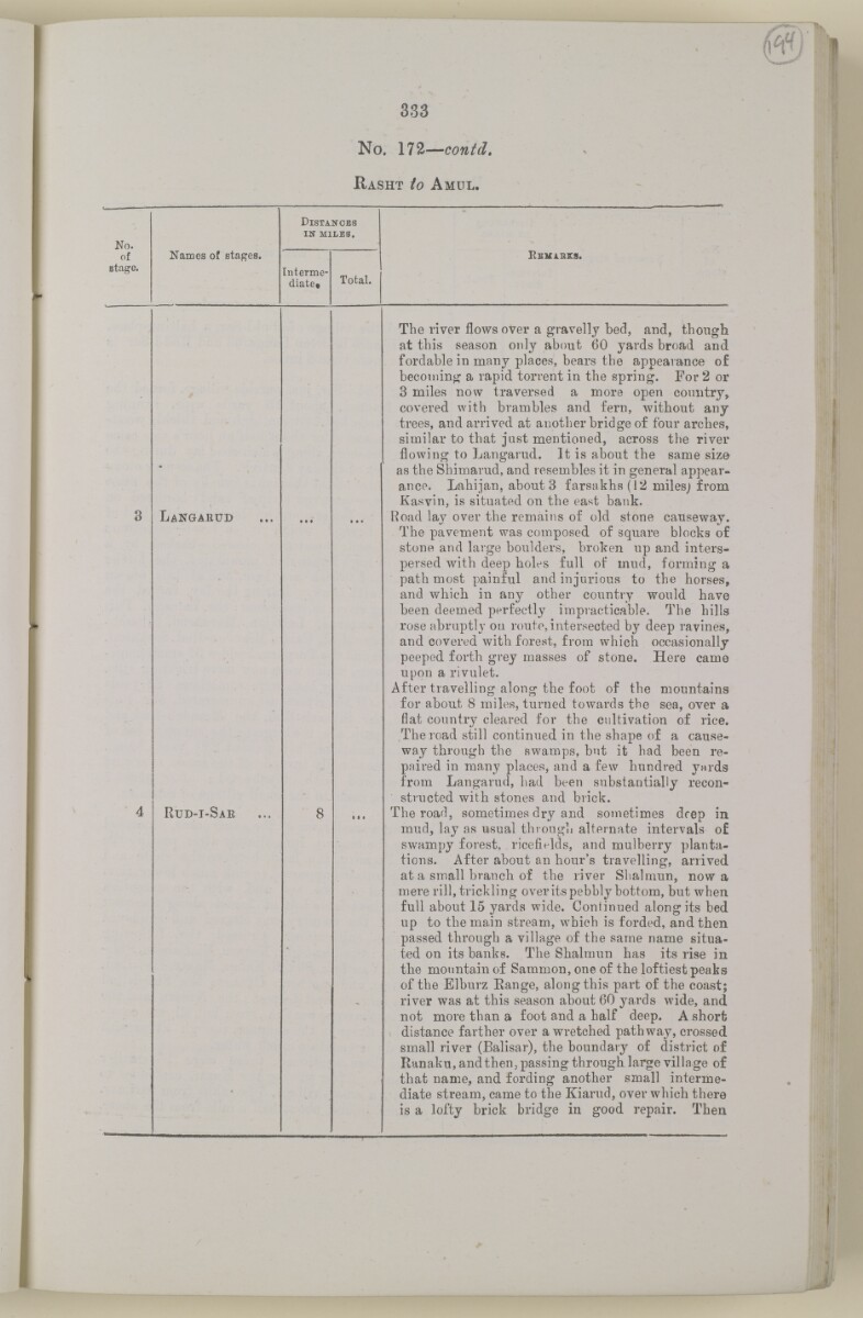
333
No. 172— contd,
H asht io A mul.
D istanobs
No.
in miles.
of
Names of stages.
K emibes.
stage.
Interme
diate*
Total.
Langarud
Rud-i-Sae
The river flows over a gravelly bed, and, though
at this season only about 60 yards broad and.
fordable in many places, bears the appearance of
becoming a rapid torrent in the spring. For 2 or
3 miles now traversed a more open country,
covered with brambles and fern, without any
trees, and arrived at another bridge of four arches,
similar to that just mentioned, across the river
flowing to Langarud. It is about the same size
as the Shimarud, and resembles it in general appear
ance. Lahijan, about 3 farsakhs(12 milesj from
Kasvin, is situated on the east bank.
Road lay over the remains of old stone causeway.
The pavement was composed, of square blocks of
stone and large boulders, broken up and inters
persed with deep holes full of mud, forming a
path most painful and injurious to the horses,
and which in any other country would have
been deemed perfectly impracticable. The hills
rose abruptly on route, intersected by deep ravines,
and covered with forest, from which occasionally
peeped, forth grey masses of stone. Here came
upon a rivulet.
After travelling along the foot of the mountains
for about 8 miles, turned towards the sea, over a
flat country cleared for the cultivation of rice.
The road still continued in the shape of a cause
way through the swamps, but it had been re
paired in many places, and a few hundred yards
from Langarud, had been substantially recon
structed with stones and brick.
The road, sometimes dry and sometimes deep in
mud, lay as usual through alternate intervals of
swampy forest, ricefields, and mulberry planta
tions. After about an hour's travelling, arrived
at a small branch of the river Shalmun, now a
mere rill, trickling over its pebbly bottom, but when
full about 15 yards wide. Continued along its bed
up to the main stream, which is forded, and then
passed through a village of the same name situa
ted on its banks. The Shalmun has its rise in
the mountain of Sammon, one of the loftiest peaks
of the Elburz Eange, along this part of the coast;
river was at this season about 60 yards wide, and
not more than a foot and a half deep. A short
distance farther over a wretched pathway, crossed
small river (Balisar), the boundary of district of
Ranaku, and then, passing through large village of
that name, and fording another small interme
diate stream, came to the Kiarud, over which there
is a lofty brick bridge in good repair. Then
About this item
- Content
The volume is a Government of India official publication entitled Routes in Persia. Section III. Compiled in the Intelligence Branch of the Quarter Master General's Department in India (Simla: printed at the Government Central Printing Office, 1898).
The volume contains details of all land routes (numbered 1-247) in Persia starting from Russian territory and extending south as far as a line drawn from Karmanshah [Kermānshāh] south-eastwards through Burujird [Borūjerd], Isfahan [Eşfahān] and Yazd to Karman [Kermān], and thence north-east to Khabis [Khabīş] and Neh to Lash Juwain [Lāsh-e Juwayn].
The information given for each route comprises:
- number of route;
- place names forming starting point and destination of route;
- authority and date;
- number of stage;
- names of stages;
- distance in miles (intermediate and total);
- remarks (including precise details of the route, general geographical information, and information on smaller settlements, local peoples, agriculture, condition of roads, access to water, supplies of wood, and other routes).
An appendix within the volume (folios 356-359) and two separately-stored sets of loose sheets (containing routes numbers 77 (a) and 140-A, folios 363-369) give information too late for incorporation in the body of the work.
The volume also contains pockets attached to the front and back inside covers for maps. These consist of an index map showing the limits of each of the three sections of Routes in Persia (folio 2) and an index map to the routes in Section III (folio 361). There is also a fold-out map of the route from Seistan [Sīstān] to Mashad on folio 232.
An ink stamp on the front cover records the confidential nature of the publication and that it was being transmitted for the information of His Excellency the Viceroy (Victor Alexander Bruce, 9th Earl of Elgin and 16th Earl of Kincardine) only.
- Extent and format
- 1 volume (367 folios)
- Arrangement
The volume contains an alphabetical cross index (folios 6-17), and an alphabetical index to names of places (folios 18-25).
- Physical characteristics
Foliation: the foliation sequence commences at the front cover and terminates on the last page of the loose supplementary sheets (found in the small grey folder within the main folder); these numbers are written in pencil, are circled, and are located in the top right corner of the recto The front of a sheet of paper or leaf, often abbreviated to 'r'. side of each folio.
Pagination: the volume also contains a printed pagination sequence.
- Written in
- English in Latin script View the complete information for this record
Use and share this item
- Share this item
'ROUTES IN PERSIA. SECTION III' [194r] (392/739), British Library: India Office Records and Private Papers, Mss Eur F111/371, in Qatar Digital Library <https://www.qdl.qa/archive/81055/vdc_100024054421.0x0000bf> [accessed 24 April 2024]
https://www.qdl.qa/en/archive/81055/vdc_100024054421.0x0000bf
Copy and paste the code below into your web page where you would like to embed the image.
<meta charset="utf-8"><a href="https://www.qdl.qa/en/archive/81055/vdc_100024054421.0x0000bf">'ROUTES IN PERSIA. SECTION III' [‎194r] (392/739)</a> <a href="https://www.qdl.qa/en/archive/81055/vdc_100024054421.0x0000bf"> <img src="https://iiif.qdl.qa/iiif/images/81055/vdc_100000001491.0x000114/Mss Eur F111_371_0390.jp2/full/!280,240/0/default.jpg" alt="" /> </a>
This record has a IIIF manifest available as follows. If you have a compatible viewer you can drag the icon to load it.https://www.qdl.qa/en/iiif/81055/vdc_100000001491.0x000114/manifestOpen in Universal viewerOpen in Mirador viewerMore options for embedding images
Copyright: How to use this content
- Reference
- Mss Eur F111/371
- Title
- 'ROUTES IN PERSIA. SECTION III'
- Pages
- front, back, spine, edge, head, tail, front-i, 2r:58r, 59r:232r, 232r:233r, 234r:361v, back-i, 363r:363v, 365r:369v
- Author
- East India Company, the Board of Control, the India Office, or other British Government Department
- Usage terms
- Open Government Licence