!['ROUTES IN PERSIA. SECTION III' [‎204r] (412/739)](https://iiif.qdl.qa/iiif/images/81055/vdc_100000001491.0x000114/Mss Eur F111_371_0410.jp2/full/!1200,1200/0/default.jpg "'ROUTES IN PERSIA. SECTION III' [‎204r] (412/739)")
'ROUTES IN PERSIA. SECTION III' [204r] (412/739)
The record is made up of 1 volume (367 folios). It was created in 1898. It was written in English. The original is part of the British Library: India Office The department of the British Government to which the Government of India reported between 1858 and 1947. The successor to the Court of Directors. Records and Private Papers Documents collected in a private capacity. .
Transcription
This transcription is created automatically. It may contain errors.
45
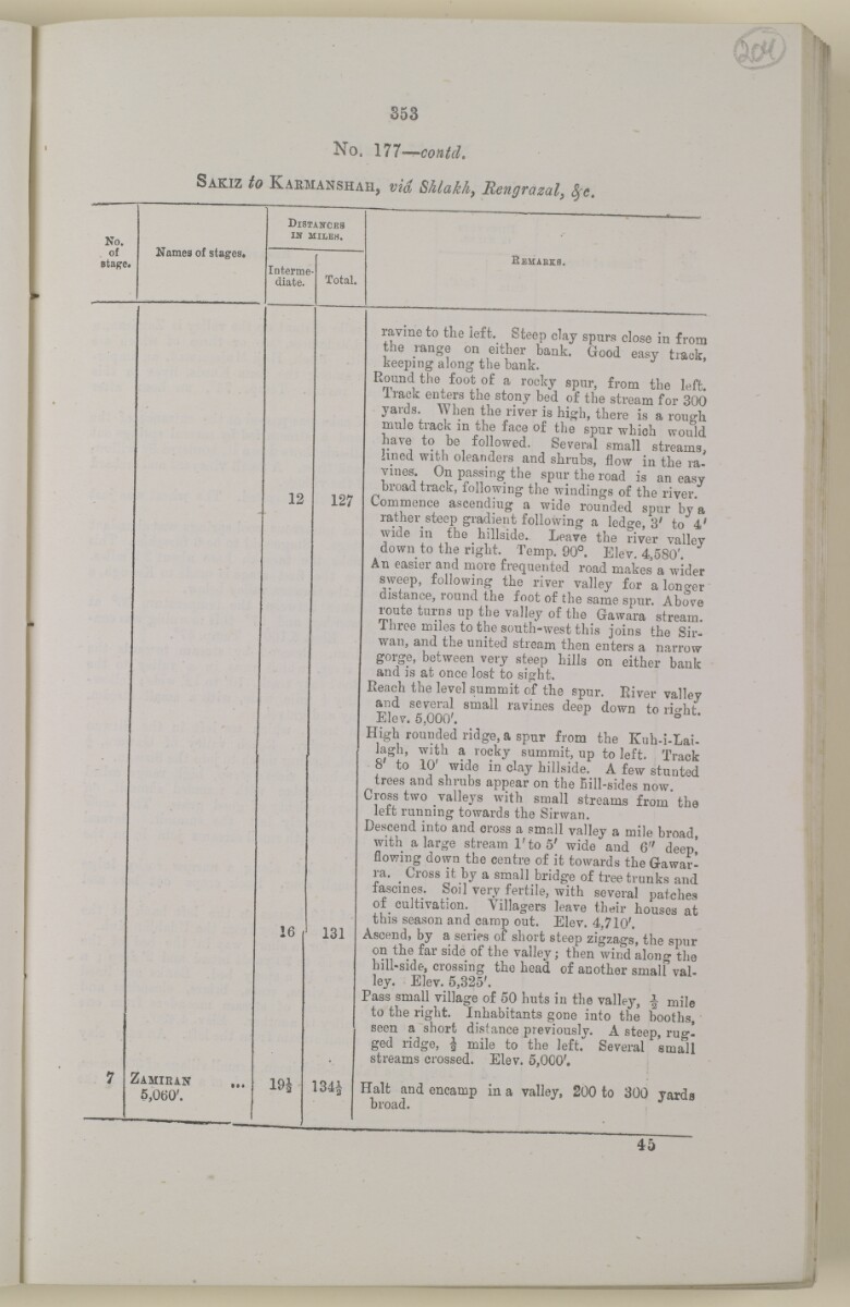
353
No. 177—
Sakiz to Kaemanshah, vid
No.
of
stage.
Names of stages.
DlSTABTCEa
IN mileh.
- ■■ —
Interme
diate.
Total.
Remabks.
7 :
Zamiein
6,060'.
..
12
16
19i
127
131
134|
ravine to the ieft. Steep clay spurs close in from
the range on either bank. Good easy track,
keeping along the bank.
Round the foot of a rocky spur, from the left.
Irack enters the stony bed of the stream for 300
yards. When the river is high, there is a rough
mule track in the face of the spur which would
have to be followed. Several small streams,
lined with oleanders and shrubs, flow in the ra
vines. On passing the spur the road is an easy
broad track, following the windings of the river
Commence ascending a wide rounded spur bva
rather steep gradient following a ledge, 3' to 4 ;
wide in the hillside.. Leave the river vallev
down to the right. Temp. 90°. Elev. 4,580'.
An easier and more frequented road makes a wider
sweep, following the river valley for a loneer
distance, round the foot of the same spur. Above
route turns up the valley of the Gawara stream.
Ihree miles to the south-west this joins the Sir-
wan, and the united stream then enters a narrow
gorge, between very steep hills on either bank
and is at once lost to sight.
Reach the level summit of the spur. River vallev
and several small ravines deep down to rio-ht
Elev. 5,000'. * 0 l '
High rounded ridge, a spur from the Kuh-i-Lai-
iagh, with a rocky summit, up to left. Track
8 to 10 wide in day hillside. A few stunted
trees and shrubs appear on the Bill-sides now.
Cross two valleys with small streams from the
leit running towards the Sirwan.
Descend into and cross a small valley a mile broad,
with a large stream 1'to 5' wide and 6" deep*
flowing down the centre of it towards the Gawar-
ra. ^ Cross it by a small bridge of tree trunks and
lascines. Soil very fertile, with several patches
of cultivation. Villagers leave their houses at
this season and camp out. Elev. 4.710'.
Ascend, by a series of short steep zigzags', the spur
on the far side of the valley; then wind along the
hili-side, crossing the head of another small val
ley. Elev. 5,325'.
Pass small village of 50 huts in the valley, f mile
to the right. Inhabitants gone into the booths,
seen a short distance previously. A steep, rug
ged ridge, J mile to the left. Several small
streams crossed. Elev. 5,000',
Halt and encamp in a valley, 200 to 300 yards
broad.
About this item
- Content
The volume is a Government of India official publication entitled Routes in Persia. Section III. Compiled in the Intelligence Branch of the Quarter Master General's Department in India (Simla: printed at the Government Central Printing Office, 1898).
The volume contains details of all land routes (numbered 1-247) in Persia starting from Russian territory and extending south as far as a line drawn from Karmanshah [Kermānshāh] south-eastwards through Burujird [Borūjerd], Isfahan [Eşfahān] and Yazd to Karman [Kermān], and thence north-east to Khabis [Khabīş] and Neh to Lash Juwain [Lāsh-e Juwayn].
The information given for each route comprises:
- number of route;
- place names forming starting point and destination of route;
- authority and date;
- number of stage;
- names of stages;
- distance in miles (intermediate and total);
- remarks (including precise details of the route, general geographical information, and information on smaller settlements, local peoples, agriculture, condition of roads, access to water, supplies of wood, and other routes).
An appendix within the volume (folios 356-359) and two separately-stored sets of loose sheets (containing routes numbers 77 (a) and 140-A, folios 363-369) give information too late for incorporation in the body of the work.
The volume also contains pockets attached to the front and back inside covers for maps. These consist of an index map showing the limits of each of the three sections of Routes in Persia (folio 2) and an index map to the routes in Section III (folio 361). There is also a fold-out map of the route from Seistan [Sīstān] to Mashad on folio 232.
An ink stamp on the front cover records the confidential nature of the publication and that it was being transmitted for the information of His Excellency the Viceroy (Victor Alexander Bruce, 9th Earl of Elgin and 16th Earl of Kincardine) only.
- Extent and format
- 1 volume (367 folios)
- Arrangement
The volume contains an alphabetical cross index (folios 6-17), and an alphabetical index to names of places (folios 18-25).
- Physical characteristics
Foliation: the foliation sequence commences at the front cover and terminates on the last page of the loose supplementary sheets (found in the small grey folder within the main folder); these numbers are written in pencil, are circled, and are located in the top right corner of the recto The front of a sheet of paper or leaf, often abbreviated to 'r'. side of each folio.
Pagination: the volume also contains a printed pagination sequence.
- Written in
- English in Latin script View the complete information for this record
Use and share this item
- Share this item
'ROUTES IN PERSIA. SECTION III' [204r] (412/739), British Library: India Office Records and Private Papers, Mss Eur F111/371, in Qatar Digital Library <https://www.qdl.qa/archive/81055/vdc_100024054422.0x00000b> [accessed 19 April 2024]
https://www.qdl.qa/en/archive/81055/vdc_100024054422.0x00000b
Copy and paste the code below into your web page where you would like to embed the image.
<meta charset="utf-8"><a href="https://www.qdl.qa/en/archive/81055/vdc_100024054422.0x00000b">'ROUTES IN PERSIA. SECTION III' [‎204r] (412/739)</a> <a href="https://www.qdl.qa/en/archive/81055/vdc_100024054422.0x00000b"> <img src="https://iiif.qdl.qa/iiif/images/81055/vdc_100000001491.0x000114/Mss Eur F111_371_0410.jp2/full/!280,240/0/default.jpg" alt="" /> </a>
This record has a IIIF manifest available as follows. If you have a compatible viewer you can drag the icon to load it.https://www.qdl.qa/en/iiif/81055/vdc_100000001491.0x000114/manifestOpen in Universal viewerOpen in Mirador viewerMore options for embedding images
Copyright: How to use this content
- Reference
- Mss Eur F111/371
- Title
- 'ROUTES IN PERSIA. SECTION III'
- Pages
- front, back, spine, edge, head, tail, front-i, 2r:58r, 59r:232r, 232r:233r, 234r:361v, back-i, 363r:363v, 365r:369v
- Author
- East India Company, the Board of Control, the India Office, or other British Government Department
- Usage terms
- Open Government Licence