!['ROUTES IN PERSIA. SECTION III' [‎238r] (480/739)](https://iiif.qdl.qa/iiif/images/81055/vdc_100000001491.0x000114/Mss Eur F111_371_0480.jp2/full/!1200,1200/0/default.jpg "'ROUTES IN PERSIA. SECTION III' [‎238r] (480/739)")
'ROUTES IN PERSIA. SECTION III' [238r] (480/739)
The record is made up of 1 volume (367 folios). It was created in 1898. It was written in English. The original is part of the British Library: India Office The department of the British Government to which the Government of India reported between 1858 and 1947. The successor to the Court of Directors. Records and Private Papers Documents collected in a private capacity. .
Transcription
This transcription is created automatically. It may contain errors.
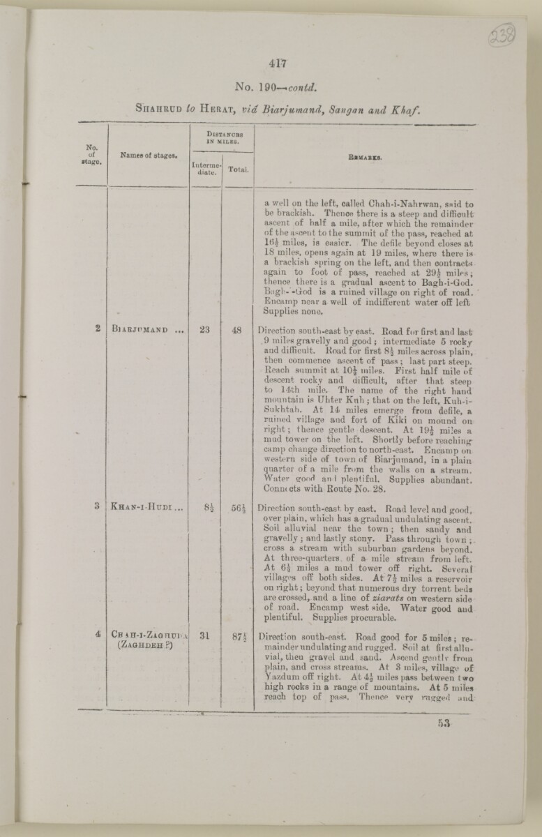
417
53
No. \d§-~*contd.
Siiahrud to Herat, via Biarjumand, Sangan and Khaf.
No.
D istanchs
IN MILES.
of
■tage.
Names of stagest
Interme
diate.
Total.
B iuabxs.
a well on the left, called Chah-i-Nahrwan, SMid to
be brackish. Thence there is a steep and difficult
ascent of half a mile, after which the remainder
of the ascent to the summit of the pass, reached at
miles, is easier. The defile beyond closes at
IS miles, opens again at 19 miles, where there is
a brackish spring on the left, and then contracts
again to foot of pass, reached at 29| milps;
thence there is a gradual ascent to Bagh-i-God.
B;igh- -God is a ruined village on right of road.
Encamp near a well of indifferent water off left
Supplies none.
2
B jarjhmand ...
N
23
48
Direction south-east by east. Eoad for first and last
9 miles gravelly and good ; intermediate 5 rocky
and difficult. Road for first 8| miles across plain,
then commence ascent of pass ; last part steep.
Reach summit at 10J miles. First half mile of
descent rocky and difficult, after that steep
to 14th mile. The name of the right hand
mountain is Uhter Kuh ; that on the left, Kuh-i-
Sukhtah. At 14 miles emerge from defile, a
ruined village and fort of Kiki on mound on
right; thence gentle descent. At 19J miles a
mud tower on the left. Shortly before reaching
camp change direction to north-east. Encamp on
western side of town of Biarjumand, in a plain
quarter of a mile from the walls on a stream.
Water crooH an ! plentiful. Supplies abundant.
Conmcts with Route No. 28.
3
K han-i H udi ...
8|
56J
Direction south-east by east. Road level and good,
over plain, which has a gradual undulating ascent.
Soil alluvial near the town ; then sandy and
gravelly ; and lastly stony. Pass through town ;
cross a stream with suburban gardens beyond.
At three-quarters of a mile stream from left.
At 6| miles a mud tower off right. Severai
villages off both sides. At 7| miles a reservoir
on right; beyond that numerous dry torrent beds
are crossed, and a line of ziarats on western side
of road. Encamp west side. Water good and
plentiful. Supplies procurable.
4
CB iH-I-ZAGHUI'A
(Z aghdeh P)
31
■ ■ i
00
<r
ta;t-
Direction south-east. Road good for 5 miles ; re
mainder undulating and rugged. Soil at firstallu-
vial, then gravel and sand. Ascend gentlv from
plain, and cross streams. At 3 miles, village of
Yazdum off right. At 4| miles pass between two
high rocks in a range of mountains. At 5 miles
reach top of pass. Thence very nigged and
About this item
- Content
The volume is a Government of India official publication entitled Routes in Persia. Section III. Compiled in the Intelligence Branch of the Quarter Master General's Department in India (Simla: printed at the Government Central Printing Office, 1898).
The volume contains details of all land routes (numbered 1-247) in Persia starting from Russian territory and extending south as far as a line drawn from Karmanshah [Kermānshāh] south-eastwards through Burujird [Borūjerd], Isfahan [Eşfahān] and Yazd to Karman [Kermān], and thence north-east to Khabis [Khabīş] and Neh to Lash Juwain [Lāsh-e Juwayn].
The information given for each route comprises:
- number of route;
- place names forming starting point and destination of route;
- authority and date;
- number of stage;
- names of stages;
- distance in miles (intermediate and total);
- remarks (including precise details of the route, general geographical information, and information on smaller settlements, local peoples, agriculture, condition of roads, access to water, supplies of wood, and other routes).
An appendix within the volume (folios 356-359) and two separately-stored sets of loose sheets (containing routes numbers 77 (a) and 140-A, folios 363-369) give information too late for incorporation in the body of the work.
The volume also contains pockets attached to the front and back inside covers for maps. These consist of an index map showing the limits of each of the three sections of Routes in Persia (folio 2) and an index map to the routes in Section III (folio 361). There is also a fold-out map of the route from Seistan [Sīstān] to Mashad on folio 232.
An ink stamp on the front cover records the confidential nature of the publication and that it was being transmitted for the information of His Excellency the Viceroy (Victor Alexander Bruce, 9th Earl of Elgin and 16th Earl of Kincardine) only.
- Extent and format
- 1 volume (367 folios)
- Arrangement
The volume contains an alphabetical cross index (folios 6-17), and an alphabetical index to names of places (folios 18-25).
- Physical characteristics
Foliation: the foliation sequence commences at the front cover and terminates on the last page of the loose supplementary sheets (found in the small grey folder within the main folder); these numbers are written in pencil, are circled, and are located in the top right corner of the recto The front of a sheet of paper or leaf, often abbreviated to 'r'. side of each folio.
Pagination: the volume also contains a printed pagination sequence.
- Written in
- English in Latin script View the complete information for this record
Use and share this item
- Share this item
'ROUTES IN PERSIA. SECTION III' [238r] (480/739), British Library: India Office Records and Private Papers, Mss Eur F111/371, in Qatar Digital Library <https://www.qdl.qa/archive/81055/vdc_100024054422.0x00004f> [accessed 20 April 2024]
https://www.qdl.qa/en/archive/81055/vdc_100024054422.0x00004f
Copy and paste the code below into your web page where you would like to embed the image.
<meta charset="utf-8"><a href="https://www.qdl.qa/en/archive/81055/vdc_100024054422.0x00004f">'ROUTES IN PERSIA. SECTION III' [‎238r] (480/739)</a> <a href="https://www.qdl.qa/en/archive/81055/vdc_100024054422.0x00004f"> <img src="https://iiif.qdl.qa/iiif/images/81055/vdc_100000001491.0x000114/Mss Eur F111_371_0480.jp2/full/!280,240/0/default.jpg" alt="" /> </a>
This record has a IIIF manifest available as follows. If you have a compatible viewer you can drag the icon to load it.https://www.qdl.qa/en/iiif/81055/vdc_100000001491.0x000114/manifestOpen in Universal viewerOpen in Mirador viewerMore options for embedding images
Copyright: How to use this content
- Reference
- Mss Eur F111/371
- Title
- 'ROUTES IN PERSIA. SECTION III'
- Pages
- front, back, spine, edge, head, tail, front-i, 2r:58r, 59r:232r, 232r:233r, 234r:361v, back-i, 363r:363v, 365r:369v
- Author
- East India Company, the Board of Control, the India Office, or other British Government Department
- Usage terms
- Open Government Licence