!['ROUTES IN PERSIA. SECTION III' [‎300r] (604/739)](https://iiif.qdl.qa/iiif/images/81055/vdc_100000001491.0x000114/Mss Eur F111_371_0604.jp2/full/!1200,1200/0/default.jpg "'ROUTES IN PERSIA. SECTION III' [‎300r] (604/739)")
'ROUTES IN PERSIA. SECTION III' [300r] (604/739)
The record is made up of 1 volume (367 folios). It was created in 1898. It was written in English. The original is part of the British Library: India Office The department of the British Government to which the Government of India reported between 1858 and 1947. The successor to the Court of Directors. Records and Private Papers Documents collected in a private capacity. .
Transcription
This transcription is created automatically. It may contain errors.
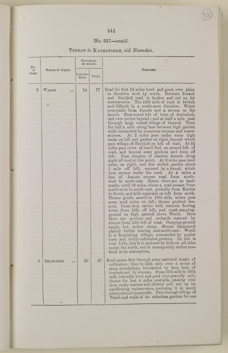
541
No. m —co
Tehran to Kaumanshah, via
No.
Distances
in - mileb.
Bemabes.
of
stage.
Names of stages.
nterme-
diate.
Total.
5
Waedi
#
14
77
Road for first 13 miles level and good, over plain
in direction west by sonth. Between Zarand
and Panijird road is broken and cut np by
watercourses. The 14th mile of road is broken
and difficult in a north-west direction. Water
procurable from Jcanats and a stream on the
march. Pass round left of town of Amirabad,
and over ravine beyond ; and at half a mile pass
through large ruined village of Garand. Then
for half a mile along lane between high garden
walls intersected by numerous streams and water
courses. At 2 miles pass under some high
rocks on left and garden on right, beyond which
pass village of Panijird on left of road. At 2J
miles pass ruins of small fort on mound left of
road, and beyond some gardens and trees off
left. Pass remains of obsolete Jcanats along
right of road at this point. At 3 miles pass mud
ruins on right, and fine walled garden about
1 mile off left, watered by a Jcanat, which
here crosses under the road. At 4 miles a
line of Jcanats crosses road from north
west to south-east. Hence there are no land
marks, until 12 miles, where a road crosses from
north-west to south-past, probably from Kasvin
to Saveh, and hills approach on left from south.
Thence gentle ascent to 13th mile, where pass
some mud ruins on left; thence gradual des
cent. Cross deep ravine with torrents flowing
down from hills off left, and reach camping-
ground on high ground above Wardi. Hero
thera are gardens and orchards watered by
stream from hills left of road. Camping-ground
ample, but rather stony. Mount Damavand
plainly visible bearing east-north-east. Wardi
is a flourishing village, surrounded by poplar
trees and richly-cultivated gardens. Its site is
very lofty, but it is enclosed by hills on all sides
except the north, and is consequently rather con
fined in its atmosphere.
6
Shamaein
20
97
Road passes first through some scattered tracts of
cultivation; then to 13th mile over a series of
steep undulations, intersected by deep beds of
torrents and by streams. From 13th mile to 16tli
mile tolerably'level and good over gravelly soil;
thence for last 4 miles execrable^ passing over
deep rocky ravines and alluvial soil, cut up by
overflowing watercourses, rendering it in many
places almost impassable. Pass through village of
Wardi and walls of its suburban gardens for one
About this item
- Content
The volume is a Government of India official publication entitled Routes in Persia. Section III. Compiled in the Intelligence Branch of the Quarter Master General's Department in India (Simla: printed at the Government Central Printing Office, 1898).
The volume contains details of all land routes (numbered 1-247) in Persia starting from Russian territory and extending south as far as a line drawn from Karmanshah [Kermānshāh] south-eastwards through Burujird [Borūjerd], Isfahan [Eşfahān] and Yazd to Karman [Kermān], and thence north-east to Khabis [Khabīş] and Neh to Lash Juwain [Lāsh-e Juwayn].
The information given for each route comprises:
- number of route;
- place names forming starting point and destination of route;
- authority and date;
- number of stage;
- names of stages;
- distance in miles (intermediate and total);
- remarks (including precise details of the route, general geographical information, and information on smaller settlements, local peoples, agriculture, condition of roads, access to water, supplies of wood, and other routes).
An appendix within the volume (folios 356-359) and two separately-stored sets of loose sheets (containing routes numbers 77 (a) and 140-A, folios 363-369) give information too late for incorporation in the body of the work.
The volume also contains pockets attached to the front and back inside covers for maps. These consist of an index map showing the limits of each of the three sections of Routes in Persia (folio 2) and an index map to the routes in Section III (folio 361). There is also a fold-out map of the route from Seistan [Sīstān] to Mashad on folio 232.
An ink stamp on the front cover records the confidential nature of the publication and that it was being transmitted for the information of His Excellency the Viceroy (Victor Alexander Bruce, 9th Earl of Elgin and 16th Earl of Kincardine) only.
- Extent and format
- 1 volume (367 folios)
- Arrangement
The volume contains an alphabetical cross index (folios 6-17), and an alphabetical index to names of places (folios 18-25).
- Physical characteristics
Foliation: the foliation sequence commences at the front cover and terminates on the last page of the loose supplementary sheets (found in the small grey folder within the main folder); these numbers are written in pencil, are circled, and are located in the top right corner of the recto The front of a sheet of paper or leaf, often abbreviated to 'r'. side of each folio.
Pagination: the volume also contains a printed pagination sequence.
- Written in
- English in Latin script View the complete information for this record
Use and share this item
- Share this item
'ROUTES IN PERSIA. SECTION III' [300r] (604/739), British Library: India Office Records and Private Papers, Mss Eur F111/371, in Qatar Digital Library <https://www.qdl.qa/archive/81055/vdc_100024054423.0x000003> [accessed 19 April 2024]
https://www.qdl.qa/en/archive/81055/vdc_100024054423.0x000003
Copy and paste the code below into your web page where you would like to embed the image.
<meta charset="utf-8"><a href="https://www.qdl.qa/en/archive/81055/vdc_100024054423.0x000003">'ROUTES IN PERSIA. SECTION III' [‎300r] (604/739)</a> <a href="https://www.qdl.qa/en/archive/81055/vdc_100024054423.0x000003"> <img src="https://iiif.qdl.qa/iiif/images/81055/vdc_100000001491.0x000114/Mss Eur F111_371_0604.jp2/full/!280,240/0/default.jpg" alt="" /> </a>
This record has a IIIF manifest available as follows. If you have a compatible viewer you can drag the icon to load it.https://www.qdl.qa/en/iiif/81055/vdc_100000001491.0x000114/manifestOpen in Universal viewerOpen in Mirador viewerMore options for embedding images
Copyright: How to use this content
- Reference
- Mss Eur F111/371
- Title
- 'ROUTES IN PERSIA. SECTION III'
- Pages
- front, back, spine, edge, head, tail, front-i, 2r:58r, 59r:232r, 232r:233r, 234r:361v, back-i, 363r:363v, 365r:369v
- Author
- East India Company, the Board of Control, the India Office, or other British Government Department
- Usage terms
- Open Government Licence