!['ROUTES IN PERSIA. SECTION III' [‎338r] (680/739)](https://iiif.qdl.qa/iiif/images/81055/vdc_100000001491.0x000114/Mss Eur F111_371_0680.jp2/full/!1200,1200/0/default.jpg "'ROUTES IN PERSIA. SECTION III' [‎338r] (680/739)")
'ROUTES IN PERSIA. SECTION III' [338r] (680/739)
The record is made up of 1 volume (367 folios). It was created in 1898. It was written in English. The original is part of the British Library: India Office The department of the British Government to which the Government of India reported between 1858 and 1947. The successor to the Court of Directors. Records and Private Papers Documents collected in a private capacity. .
Transcription
This transcription is created automatically. It may contain errors.
V.
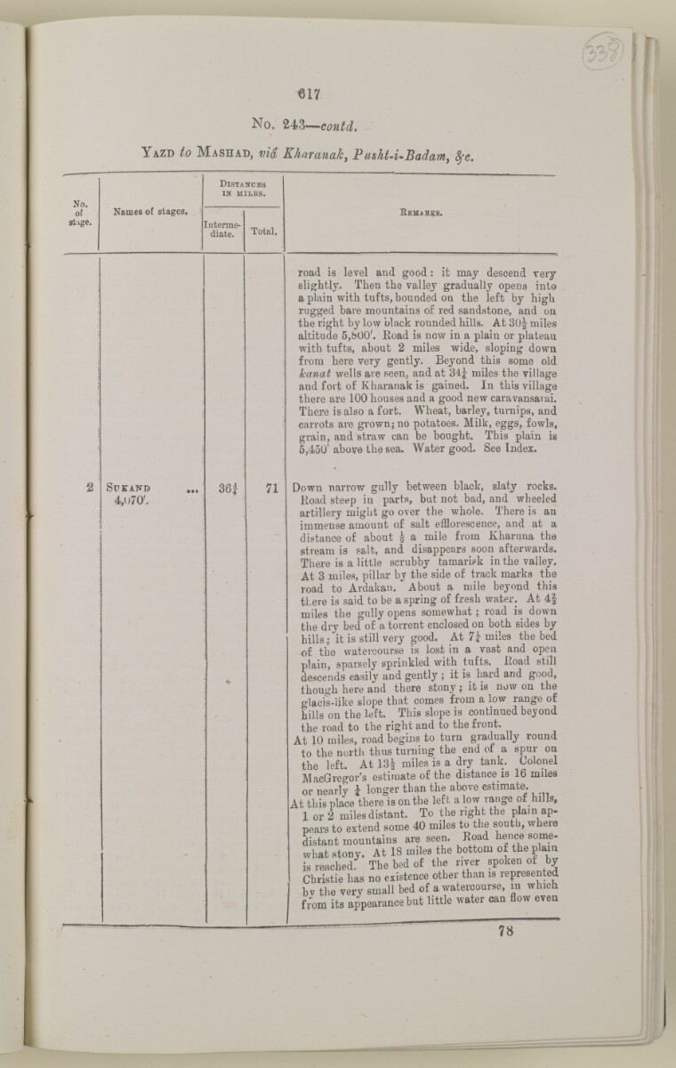
617
No. 243— contcL
Y azd to M ash ad, via Kharanak, F usht-i-Badam, tye.
No.
of
st :lge.
Names of stages.
D istances
in miles.
E emabes.
[uterme-
diate.
Total.
2
r-
SUKAND
4,u70'.
36 i
%
71
road is level and good : it maj descend very
slightly. Then the valley gradually opens into
a plain with tufts, bounded on the left by high
rugged bare mountains of red sandstone, and on
the right by low black rounded hills. At SOJ miles
altitude 5,b00'. Eoad is now in a plain or plateau
with tufts, about 2 miles wide, sloping down
from here very gently. Beyond this some old
kanat wells are seen, and at 34J miles the village
and fort of Kharanak is gained. In this village
there are 100 houses and a good new caravansarai.
There is also a fort. Wheat, barley, turnips, and
carrots are grown; no potatoes. Milk, eggs, fowls,
grain, and straw can be bought. This plain is
5,450' above the sea. Water good. See Index.
Down narrow gully between black, slaty rocks.
Road steep in parts, but not bad, and wheeled
artillery might go over the whole. There is an
immense amount of salt efflorescence, and at a
distance of about | a mile from Kharuna the
stream is salt, and disappears soon afterwards.
There is a little scrubby tamarisk in the valley.
At 3 miles, pillar b^ the side of track marks the
road to Ardakan. About a mile beyond this
there is said to be a spring of fresh water. At 4|
miles the gully opens somewhat; road is down
the dry bed of a torrent enclosed on both sides by
hills; it is still very good. At 7i miles the bed
of the watercourse is lost in a vast and open
plain, sparsely sprinkled with tufts, Koad still
descends easily and gently ; it is hard and good,
though here and there stony ; it is now on the
glacis-like slope that comes from a low range of
hills on the left. This slope is continued beyond
the road to the right and to the front.
At 10 miles, road begins to turn gradually round
to the north thus turning the end of a spur on
the left. At 13i miles is a dry tank. Colonel
MacGregor's estimate of the distance is 16 miles
or nearly \ longer than the above estimate.
At this place there is on the left a low range of hills,
I or 2 miles distant. To the right the plain ap-
pears to extend some 40 miles to the south, where
distant mountains are seen. Road hence some
what stony. At 18 miles the bottom of the plain
is reached: The bed of the river spoken ot by
Christie has no existence other than is lepresented
bv the very small bed of a watercourse, in which
from its appearance but little water can flow even
II 1 1 11
About this item
- Content
The volume is a Government of India official publication entitled Routes in Persia. Section III. Compiled in the Intelligence Branch of the Quarter Master General's Department in India (Simla: printed at the Government Central Printing Office, 1898).
The volume contains details of all land routes (numbered 1-247) in Persia starting from Russian territory and extending south as far as a line drawn from Karmanshah [Kermānshāh] south-eastwards through Burujird [Borūjerd], Isfahan [Eşfahān] and Yazd to Karman [Kermān], and thence north-east to Khabis [Khabīş] and Neh to Lash Juwain [Lāsh-e Juwayn].
The information given for each route comprises:
- number of route;
- place names forming starting point and destination of route;
- authority and date;
- number of stage;
- names of stages;
- distance in miles (intermediate and total);
- remarks (including precise details of the route, general geographical information, and information on smaller settlements, local peoples, agriculture, condition of roads, access to water, supplies of wood, and other routes).
An appendix within the volume (folios 356-359) and two separately-stored sets of loose sheets (containing routes numbers 77 (a) and 140-A, folios 363-369) give information too late for incorporation in the body of the work.
The volume also contains pockets attached to the front and back inside covers for maps. These consist of an index map showing the limits of each of the three sections of Routes in Persia (folio 2) and an index map to the routes in Section III (folio 361). There is also a fold-out map of the route from Seistan [Sīstān] to Mashad on folio 232.
An ink stamp on the front cover records the confidential nature of the publication and that it was being transmitted for the information of His Excellency the Viceroy (Victor Alexander Bruce, 9th Earl of Elgin and 16th Earl of Kincardine) only.
- Extent and format
- 1 volume (367 folios)
- Arrangement
The volume contains an alphabetical cross index (folios 6-17), and an alphabetical index to names of places (folios 18-25).
- Physical characteristics
Foliation: the foliation sequence commences at the front cover and terminates on the last page of the loose supplementary sheets (found in the small grey folder within the main folder); these numbers are written in pencil, are circled, and are located in the top right corner of the recto The front of a sheet of paper or leaf, often abbreviated to 'r'. side of each folio.
Pagination: the volume also contains a printed pagination sequence.
- Written in
- English in Latin script View the complete information for this record
Use and share this item
- Share this item
'ROUTES IN PERSIA. SECTION III' [338r] (680/739), British Library: India Office Records and Private Papers, Mss Eur F111/371, in Qatar Digital Library <https://www.qdl.qa/archive/81055/vdc_100024054423.0x00004f> [accessed 18 April 2024]
https://www.qdl.qa/en/archive/81055/vdc_100024054423.0x00004f
Copy and paste the code below into your web page where you would like to embed the image.
<meta charset="utf-8"><a href="https://www.qdl.qa/en/archive/81055/vdc_100024054423.0x00004f">'ROUTES IN PERSIA. SECTION III' [‎338r] (680/739)</a> <a href="https://www.qdl.qa/en/archive/81055/vdc_100024054423.0x00004f"> <img src="https://iiif.qdl.qa/iiif/images/81055/vdc_100000001491.0x000114/Mss Eur F111_371_0680.jp2/full/!280,240/0/default.jpg" alt="" /> </a>
This record has a IIIF manifest available as follows. If you have a compatible viewer you can drag the icon to load it.https://www.qdl.qa/en/iiif/81055/vdc_100000001491.0x000114/manifestOpen in Universal viewerOpen in Mirador viewerMore options for embedding images
Copyright: How to use this content
- Reference
- Mss Eur F111/371
- Title
- 'ROUTES IN PERSIA. SECTION III'
- Pages
- front, back, spine, edge, head, tail, front-i, 2r:58r, 59r:232r, 232r:233r, 234r:361v, back-i, 363r:363v, 365r:369v
- Author
- East India Company, the Board of Control, the India Office, or other British Government Department
- Usage terms
- Open Government Licence