!['ROUTES IN PERSIA, Section 1.' [‎30v] (65/416)](https://iiif.qdl.qa/iiif/images/81055/vdc_100000001491.0x000111/Mss Eur F111_369_0065.jp2/full/!1200,1200/0/default.jpg "'ROUTES IN PERSIA, Section 1.' [‎30v] (65/416)")
'ROUTES IN PERSIA, Section 1.' [30v] (65/416)
The record is made up of 1 volume (206 folios). It was created in 1898. It was written in English. The original is part of the British Library: India Office The department of the British Government to which the Government of India reported between 1858 and 1947. The successor to the Court of Directors. Records and Private Papers Documents collected in a private capacity. .
Transcription
This transcription is created automatically. It may contain errors.
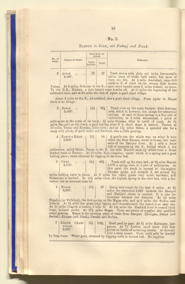
26
No. 7.
Bampuk to Jalk, vid Pahraj and Dizak.
No. of
stage.
Distance, in
milks.
Names of stages.
Inter
mediate-
Total.
Rbuabes.
2
Aptab
2,400'.
12
27
Track over a wide plain cut up by innumerable
nalas, some of which hold water, but most of
them are dry. At ! mile, Asadabad, some 300
yards to N. of track on the stream that waters
Pahraj. At 6 miles, Sirkuran to the S., a good sized hamlet some 3 miles distant, no dates.
To the N.E., Karkan, a date hamlet some 4 miles off. At 11 miles the beginning of the
cultivated zone, and at 12 miles the fort of Aptar, a good sized village.
About 2 miles to the N., Ahmedabad, also a good sized village. From Aptar to Magas
there is no village.
cultivation to the south of
Soran . 11! 38! Track runs up the main Bampur river drainage
2,466'. area, which is, however, dry, except for occasional
springs. At each of these springs is a tiny plot of
cultivation, at 2 miles Asmanabad, a patch of
the track ; 3| miles Seradan, ditto to north of track. At 65
miles Bo^mahi on the track, a good halting place if a short stage is desired. Thence, at
10 miles, Tamap and Kundan, little plots; and at 11! miles Soran, a splendid site fora
camp with plenty of good water and firewood, also a little grazing.
4
Zamin-i-Khan
3,500'.
15!
54
A gentle rise the whole way up what is here
called the Nala Konaru, which is to say, the main
nala of the Bampur river. At 1 mile a dense
belt of tamarisk to the S., behind which is the
cultivation called Shirin JPatan, to the N. the wide Kusichi nala up which runs a direct
donkey track to Paskuh. At 12 miles Kuh-i-Ispidan, under which is a spring and a good
halting place ; water obtained by digging in the river bed.
Cheb
4,175'.
15!
69!
Track still up the river bed ; at 3! miles Manish
3,579' a spring close to a plot of oultivalion. At
this point the track is nearest to the mighty
Hamant peaks, and towards it are several big
nalas holding water in places. At 9 miles the valley grows very much narrower, and
Sirtanuran is reached. At 15! miles Cheb, the highest spring in the river bed, with a few
rushes, but no firewood close by.
6
Magas
3,970'.
17!
87
Going very rough for the first 5 miles. At 2!
miles the watershed 3,825' between the Bampur
and Mashkid rivers is reached. It is also the
boundary between the districts. At 5! miles
Sirpahra (or Sirfahraj), the first spring on the Magas side, and at 6 miles the Sarbaz road
joins in. At 8 ! miles the great plain begins, and thenceforward the march is an easy one.
At 11 miles Chagird, a hamlet, 1 mile S. At 14! miles the Mashkid river is crossed (with
large, isolated pools). At 17! miles Magas. There are plenty of supplies, also excellent
camel grazing. Magas is the meeting point of roads from Bampur, Eiudigan, Sistan [vi&
Sarhad), Khazan {vid Dizak), Gwadar and Sarbaz.
Khatjr Chah-
RTTKAN.
4,060'.
15!
102 !
by drag ropes. Water good, obtained by
Road good to pass. At 3| miles Kaimagar, date
groves. At 7! Koshan, small tower with date
groves on banks of a running stream. At eleventh
, mile a steep ascent. Guns could only be lowered
digging wells in torrent bed. No supplies.
About this item
- Content
The publication, Routes in Persia, Section I was compiled in the Intelligence Branch of the Quarter-Master Gerneral's Department in India and was published by the Office of the Superintendent of Government Printing, India, Calcutta: 1898.
Section I contains all the routes which commence from the Persian Gulf The historical term used to describe the body of water between the Arabian Peninsula and Iran. littoral and extending to a line drawn from Burajird [Borūjerd], through Isfahan [Eşfahān], Yazd, Karman [Kermān], Khabis [Khabīş], Neh to Lash Juwain [Lāsh-e Juwayn]; the routes have been arranged within the volume by starting from the sea base of the Persian Gulf The historical term used to describe the body of water between the Arabian Peninsula and Iran. and working up towards the line described.
For each route described the previous authorities, such as publications and accounts of journeys, are given, along with the following details:
- Names of stages: towns and villages which act as stopping points along the route;
- The distance in miles from the previous stage of the route;
- The total distance in miles for that route up to that stage;
- Remarks: including geographical information; details on smaller settlements; sacred places; condition of roads; access to water; other roads and routes.
The volume also includes two appendices which contain details of other routes for which the information was received too late to be included in the main body of the volume.
An ink stamp on the front cover records the confidential nature of the publication and that it was being transmitted for the information of His Excellency the Viceroy (Victor Alexander Bruce, 9th Earl of Elgin and 16th Earl of Kincardine) only.
The inside front and back covers have pockets containing index maps of the routes described in the volume.
- Extent and format
- 1 volume (206 folios)
- Arrangement
Folios 6-10 consist of an alphabetical index to names of places featured in the volume, excluding those places which appear in appendix II. Folios 11-17 are an alphabetical cross-index of the routes featured in the volume, again excluding those routes which appear in appendix II.
- Physical characteristics
Foliation: The foliation sequence commences at the front cover, and terminates at the inside back cover; these numbers are written in pencil, are circled, and are located in the top right corner of the recto The front of a sheet of paper or leaf, often abbreviated to 'r'. side of each folio. The volume aso contains an original printed pagination sequence.
- Written in
- English in Latin script View the complete information for this record
Use and share this item
- Share this item
'ROUTES IN PERSIA, Section 1.' [30v] (65/416), British Library: India Office Records and Private Papers, Mss Eur F111/369, in Qatar Digital Library <https://www.qdl.qa/archive/81055/vdc_100025705310.0x000042> [accessed 25 April 2024]
https://www.qdl.qa/en/archive/81055/vdc_100025705310.0x000042
Copy and paste the code below into your web page where you would like to embed the image.
<meta charset="utf-8"><a href="https://www.qdl.qa/en/archive/81055/vdc_100025705310.0x000042">'ROUTES IN PERSIA, Section 1.' [‎30v] (65/416)</a> <a href="https://www.qdl.qa/en/archive/81055/vdc_100025705310.0x000042"> <img src="https://iiif.qdl.qa/iiif/images/81055/vdc_100000001491.0x000111/Mss Eur F111_369_0065.jp2/full/!280,240/0/default.jpg" alt="" /> </a>
This record has a IIIF manifest available as follows. If you have a compatible viewer you can drag the icon to load it.https://www.qdl.qa/en/iiif/81055/vdc_100000001491.0x000111/manifestOpen in Universal viewerOpen in Mirador viewerMore options for embedding images
Copyright: How to use this content
- Reference
- Mss Eur F111/369
- Title
- 'ROUTES IN PERSIA, Section 1.'
- Pages
- front, back, spine, edge, head, tail, front-i, 2r:205v, back-i
- Author
- East India Company, the Board of Control, the India Office, or other British Government Department
- Usage terms
- Open Government Licence