!['ROUTES IN PERSIA, Section 1.' [‎35r] (74/416)](https://iiif.qdl.qa/iiif/images/81055/vdc_100000001491.0x000111/Mss Eur F111_369_0074.jp2/full/!1200,1200/0/default.jpg "'ROUTES IN PERSIA, Section 1.' [‎35r] (74/416)")
'ROUTES IN PERSIA, Section 1.' [35r] (74/416)
The record is made up of 1 volume (206 folios). It was created in 1898. It was written in English. The original is part of the British Library: India Office The department of the British Government to which the Government of India reported between 1858 and 1947. The successor to the Court of Directors. Records and Private Papers Documents collected in a private capacity. .
Transcription
This transcription is created automatically. It may contain errors.
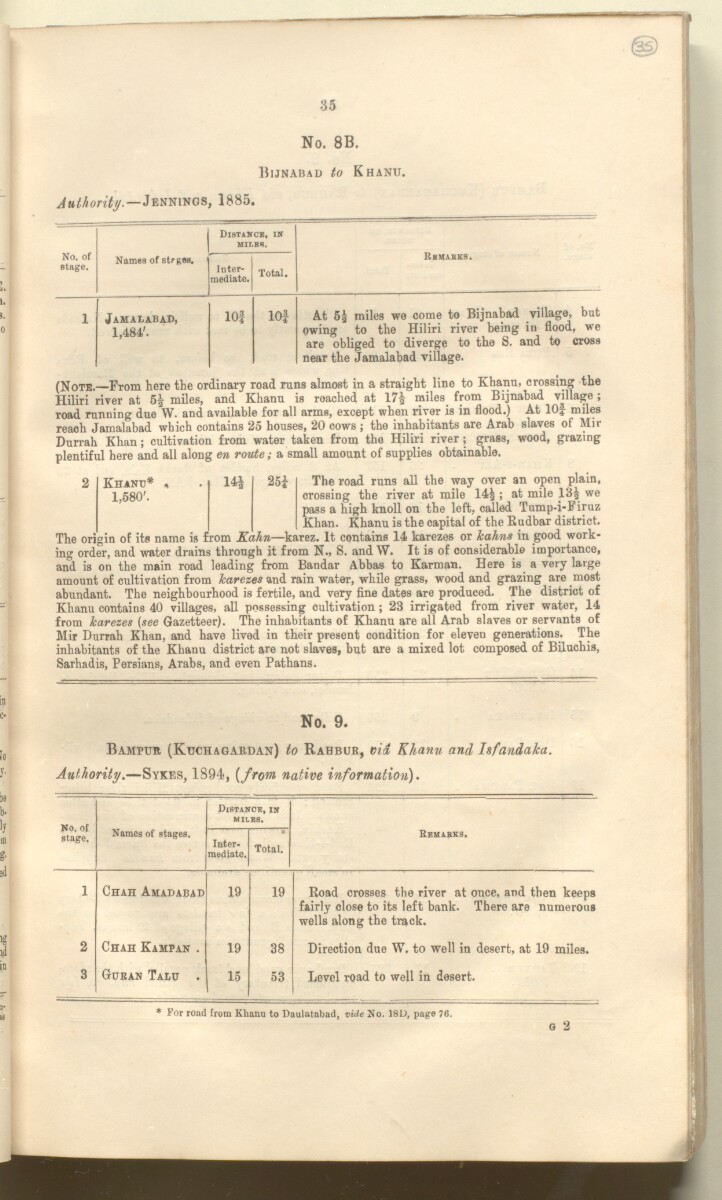
35
No. 8B.
Bijnabad to Khanu.
Authority. —Jennings, 1885.
—
Distance, in
mile*.
RBVABKS.
No. of
stage.
Names of stegsa.
Inter
mediate.
Total.
1
Jamalabad,
1,484'.
lOf
lOf
At miles we come to Bijnabad village, but
owing to the Hiliri river being in flood, we
are obliged to diverge to the S. and to cross
near the Jamalabad village.
(Notb. —From here the ordinary road runs almost in a straight line to Khanu, crossing the
Hiliri river at 5| miles, and Khanu is reached at 17£ miles from Bijnabad village ;
road running due W. and available for all arms, except when river is in flood.) At lOf miles
reach Jamalabad which contains 25 houses, 20 cows j the inhabitants are Arab slaves of Mil
Durrah Khan; cultivation from water taken from the Hiliri river ; grass, wood, grazing
plentiful here and all along en route; a small amount of supplies obtainable.
Khanu* , . 25£ The road runs all the way over an open plain,
1,580'. crossing the river at mile 14|; at mile 13^ we
pass a high knoll on the left, called Tump-i-Firuz
Khan. Khanu is the capital of the Rudbar district.
The origin of its name is from Kahn —karez. It contains 14 karezes or kahns in good work
ing order, and water drains through it from N., S. and W. It is of considerable importance,
aiS. is on the main road leading from Bandar Abbas to Karman. Here is a very large
amount of cultivation from karezes and rain water, while grass, wood and grazing are most
abundant. The neighbourhood is fertile, and very fine dates are produced. The district of
Khanu contains 40 villages, all possessing cultivation; 23 irrigated from river water, 14
from karezes (see Gazetteer). The inhabitants of Khanu are all Arab slaves or servants of
Mir Durrah Khan, and have lived in their present condition for eleven generations. The
inhabitants of the Khanu district are not slaves, but are a mixed lot composed of Biluchis,
Sarhadis, Persians, Arabs, and even Pathans.
No. 9.
Bampur (Kuchagardan) to Rabbur, via Khanu and Isfandaka.
Authority. —Sykes, 1894, {from native information).
No. of
stage.
Distance, in
miles.
Names of stages.
Inter
mediate.
Total.
Remarks.
1
Chah Amadabad
19
19
Road crosses the river at once, and then keeps
fairly close to its left bank. There are numerous
wells along the track.
2
Chah Kampan .
19
38
Direction due W. to well in desert, at 19 miles.
3
Guban Talu .
15
53
Level road to well in desert.
o 2
* For road from Khanu to Daulatabad, vide No. 18D, page 76.
About this item
- Content
The publication, Routes in Persia, Section I was compiled in the Intelligence Branch of the Quarter-Master Gerneral's Department in India and was published by the Office of the Superintendent of Government Printing, India, Calcutta: 1898.
Section I contains all the routes which commence from the Persian Gulf The historical term used to describe the body of water between the Arabian Peninsula and Iran. littoral and extending to a line drawn from Burajird [Borūjerd], through Isfahan [Eşfahān], Yazd, Karman [Kermān], Khabis [Khabīş], Neh to Lash Juwain [Lāsh-e Juwayn]; the routes have been arranged within the volume by starting from the sea base of the Persian Gulf The historical term used to describe the body of water between the Arabian Peninsula and Iran. and working up towards the line described.
For each route described the previous authorities, such as publications and accounts of journeys, are given, along with the following details:
- Names of stages: towns and villages which act as stopping points along the route;
- The distance in miles from the previous stage of the route;
- The total distance in miles for that route up to that stage;
- Remarks: including geographical information; details on smaller settlements; sacred places; condition of roads; access to water; other roads and routes.
The volume also includes two appendices which contain details of other routes for which the information was received too late to be included in the main body of the volume.
An ink stamp on the front cover records the confidential nature of the publication and that it was being transmitted for the information of His Excellency the Viceroy (Victor Alexander Bruce, 9th Earl of Elgin and 16th Earl of Kincardine) only.
The inside front and back covers have pockets containing index maps of the routes described in the volume.
- Extent and format
- 1 volume (206 folios)
- Arrangement
Folios 6-10 consist of an alphabetical index to names of places featured in the volume, excluding those places which appear in appendix II. Folios 11-17 are an alphabetical cross-index of the routes featured in the volume, again excluding those routes which appear in appendix II.
- Physical characteristics
Foliation: The foliation sequence commences at the front cover, and terminates at the inside back cover; these numbers are written in pencil, are circled, and are located in the top right corner of the recto The front of a sheet of paper or leaf, often abbreviated to 'r'. side of each folio. The volume aso contains an original printed pagination sequence.
- Written in
- English in Latin script View the complete information for this record
Use and share this item
- Share this item
'ROUTES IN PERSIA, Section 1.' [35r] (74/416), British Library: India Office Records and Private Papers, Mss Eur F111/369, in Qatar Digital Library <https://www.qdl.qa/archive/81055/vdc_100025705310.0x00004b> [accessed 23 April 2024]
https://www.qdl.qa/en/archive/81055/vdc_100025705310.0x00004b
Copy and paste the code below into your web page where you would like to embed the image.
<meta charset="utf-8"><a href="https://www.qdl.qa/en/archive/81055/vdc_100025705310.0x00004b">'ROUTES IN PERSIA, Section 1.' [‎35r] (74/416)</a> <a href="https://www.qdl.qa/en/archive/81055/vdc_100025705310.0x00004b"> <img src="https://iiif.qdl.qa/iiif/images/81055/vdc_100000001491.0x000111/Mss Eur F111_369_0074.jp2/full/!280,240/0/default.jpg" alt="" /> </a>
This record has a IIIF manifest available as follows. If you have a compatible viewer you can drag the icon to load it.https://www.qdl.qa/en/iiif/81055/vdc_100000001491.0x000111/manifestOpen in Universal viewerOpen in Mirador viewerMore options for embedding images
Copyright: How to use this content
- Reference
- Mss Eur F111/369
- Title
- 'ROUTES IN PERSIA, Section 1.'
- Pages
- front, back, spine, edge, head, tail, front-i, 2r:205v, back-i
- Author
- East India Company, the Board of Control, the India Office, or other British Government Department
- Usage terms
- Open Government Licence