!['ROUTES IN PERSIA, Section 1.' [‎114v] (233/416)](https://iiif.qdl.qa/iiif/images/81055/vdc_100000001491.0x000111/Mss Eur F111_369_0233.jp2/full/!1200,1200/0/default.jpg "'ROUTES IN PERSIA, Section 1.' [‎114v] (233/416)")
'ROUTES IN PERSIA, Section 1.' [114v] (233/416)
The record is made up of 1 volume (206 folios). It was created in 1898. It was written in English. The original is part of the British Library: India Office The department of the British Government to which the Government of India reported between 1858 and 1947. The successor to the Court of Directors. Records and Private Papers Documents collected in a private capacity. .
Transcription
This transcription is created automatically. It may contain errors.
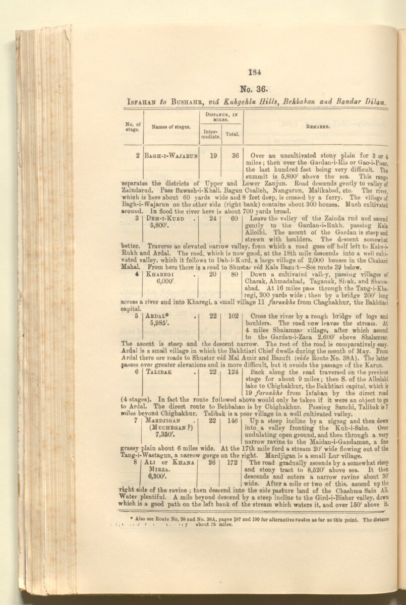
184
No. 36.
Isfahan to Bushahr, via, Knhgehlu Hills, Behlahan and Bandar Dilam.
No. of
stage.
Names of stages.
Distancb, in
MILKS.
Inter
mediate.
Total.
Bbmabks.
Bagh-i-Wajabun
19
36
better.
Deh-i-Kukd
24
60
5,800'.
Over an uncultivated stony plain for 3 or 4
miles ; then over the Gardan-i-Ris or Gao-i-Pigar,
the last hundred feet being very difficult. The
summit is 5,800' above the sea. This range
separates the districts of Upper and Lower Zanjun. Road descends gently to valley of
Zaindarud, Pass Bawash-i-Khali, Bagun Clialleh, Nangarun, Malikabad, etc. The river,
which is here about 60 yards wide and 8 feet deep, is crossed by a ferry. The village of
Bagh-i-VVajarun on the other side (right bank) contains about 300 houses. Much cultivated
around. In flood the river here is about 700 yards broad.
Leave the valley of the Zainda rud and ascend
gently to the Gardan-i-Rukh, passing Kala
Alloibi. The ascent of the Gardan is steep and
strewn with boulders. The descent somewhat
Traverse an elevated narrow valley, from which a road goes off half left to Kahv-i*
Rukh and Ardal. The road, which is now good, at the 18th mile descends into a well culti
vated valley, which it follows to Deh-i-Kurd, a large village of 2,000 houses in the Chahard
Mahal From here there is a road to Shustar vid Kala BazuL—See route 39 below.
Down a cultivated valley, passing: villages of
Charak, Ahmadabad, Taganak, Sii ak, and Shams-
abad. At 16 miles pass through the Tang-i-Kha.
regi, 300 yards wide ; then by a bridge 200' long
across a river and into Kharegi, a small village 11 farmkhs from Chaghakhur, the Bakhtiaii
capital.
Cross the river by a rough bridge of logs and
boulders. The road now leaves the stream. At
4 miles Shalamzar village, after which ascend
to the Gardan-i-Zara 2,600' above Shalamzar.
The ascent is steep and the descent narrow. The rest of the road is comparatively easy.
Ardal is a small village in which the Bakhtiari Chief dwells during the month of May. From
Ardal there are roads to Shustar vid Mai Amir and Bazuft (vide Route No. 38A). The latter
passes over greater elevations and is more difficult, but it avoids the passage of the Karim.
Kharegi
20
80
6,000'.
Abdal*
5,985'.
22
102
6
Talibak
22
124
Back along the road traversed on the previous
stage for about 9 miles ; then S. of the Albolaki
lake to Chighakhur, the Bakhtiari capital, which is
19 farsakhs from Isfahan by the direct road
(4 stages). In fact the route followed above would only be taken if it were an object to go
to Ardal. The direct route to Behbahan is by Chighakhur. Passing Sanchi, Talibak is 7
miles beyond Chighakhur. Talibak is a poor village in a well cultivated valley.
Mabdjigan
(Muchegan ?)
7,m\
22
146
Up a steep incline by a zigzag and then down
into.a valley fronting the Kuh-i-Sabz. Over
undulating open ground, and then through a very
narrow ravine to the Maidan-i-Gandaman, a fine
grassy plain about 6 miles wide. At the 17th mile ford a stream 20' wide flowing out of the
Tang-i-Wastagun, a narrow gorge on the right. Mardjigan is a small Lur village.
8
Au or Khana
Mibza.
6,300'.
26
172
The road gradually ascends by a somewhat steep
and stony tract to 8,520' above sea. It then
descends and enters a narrow ravine about 30'
wide. After a mile or two of this, ascend up the
right side of the ravine ; then descend into the side pasture land of the Chashma Sain All
Water plentiful. A mile beyond descend by a steep incline to the Gird-i-Bisher valley, down
which is a good path on the left bank of the stream which waters it, and over 150' above it.
* Also see Boute No. 38 and No. 38A, pages 197 and 199 for alternative routes as far as this point. The distance
. . i i i. . > i y about 75 miles.
About this item
- Content
The publication, Routes in Persia, Section I was compiled in the Intelligence Branch of the Quarter-Master Gerneral's Department in India and was published by the Office of the Superintendent of Government Printing, India, Calcutta: 1898.
Section I contains all the routes which commence from the Persian Gulf The historical term used to describe the body of water between the Arabian Peninsula and Iran. littoral and extending to a line drawn from Burajird [Borūjerd], through Isfahan [Eşfahān], Yazd, Karman [Kermān], Khabis [Khabīş], Neh to Lash Juwain [Lāsh-e Juwayn]; the routes have been arranged within the volume by starting from the sea base of the Persian Gulf The historical term used to describe the body of water between the Arabian Peninsula and Iran. and working up towards the line described.
For each route described the previous authorities, such as publications and accounts of journeys, are given, along with the following details:
- Names of stages: towns and villages which act as stopping points along the route;
- The distance in miles from the previous stage of the route;
- The total distance in miles for that route up to that stage;
- Remarks: including geographical information; details on smaller settlements; sacred places; condition of roads; access to water; other roads and routes.
The volume also includes two appendices which contain details of other routes for which the information was received too late to be included in the main body of the volume.
An ink stamp on the front cover records the confidential nature of the publication and that it was being transmitted for the information of His Excellency the Viceroy (Victor Alexander Bruce, 9th Earl of Elgin and 16th Earl of Kincardine) only.
The inside front and back covers have pockets containing index maps of the routes described in the volume.
- Extent and format
- 1 volume (206 folios)
- Arrangement
Folios 6-10 consist of an alphabetical index to names of places featured in the volume, excluding those places which appear in appendix II. Folios 11-17 are an alphabetical cross-index of the routes featured in the volume, again excluding those routes which appear in appendix II.
- Physical characteristics
Foliation: The foliation sequence commences at the front cover, and terminates at the inside back cover; these numbers are written in pencil, are circled, and are located in the top right corner of the recto The front of a sheet of paper or leaf, often abbreviated to 'r'. side of each folio. The volume aso contains an original printed pagination sequence.
- Written in
- English in Latin script View the complete information for this record
Use and share this item
- Share this item
'ROUTES IN PERSIA, Section 1.' [114v] (233/416), British Library: India Office Records and Private Papers, Mss Eur F111/369, in Qatar Digital Library <https://www.qdl.qa/archive/81055/vdc_100025705311.0x000022> [accessed 18 April 2024]
https://www.qdl.qa/en/archive/81055/vdc_100025705311.0x000022
Copy and paste the code below into your web page where you would like to embed the image.
<meta charset="utf-8"><a href="https://www.qdl.qa/en/archive/81055/vdc_100025705311.0x000022">'ROUTES IN PERSIA, Section 1.' [‎114v] (233/416)</a> <a href="https://www.qdl.qa/en/archive/81055/vdc_100025705311.0x000022"> <img src="https://iiif.qdl.qa/iiif/images/81055/vdc_100000001491.0x000111/Mss Eur F111_369_0233.jp2/full/!280,240/0/default.jpg" alt="" /> </a>
This record has a IIIF manifest available as follows. If you have a compatible viewer you can drag the icon to load it.https://www.qdl.qa/en/iiif/81055/vdc_100000001491.0x000111/manifestOpen in Universal viewerOpen in Mirador viewerMore options for embedding images
Copyright: How to use this content
- Reference
- Mss Eur F111/369
- Title
- 'ROUTES IN PERSIA, Section 1.'
- Pages
- front, back, spine, edge, head, tail, front-i, 2r:205v, back-i
- Author
- East India Company, the Board of Control, the India Office, or other British Government Department
- Usage terms
- Open Government Licence