!['ROUTES IN PERSIA, Section 1.' [‎115v] (235/416)](https://iiif.qdl.qa/iiif/images/81055/vdc_100000001491.0x000111/Mss Eur F111_369_0235.jp2/full/!1200,1200/0/default.jpg "'ROUTES IN PERSIA, Section 1.' [‎115v] (235/416)")
'ROUTES IN PERSIA, Section 1.' [115v] (235/416)
The record is made up of 1 volume (206 folios). It was created in 1898. It was written in English. The original is part of the British Library: India Office The department of the British Government to which the Government of India reported between 1858 and 1947. The successor to the Court of Directors. Records and Private Papers Documents collected in a private capacity. .
Transcription
This transcription is created automatically. It may contain errors.
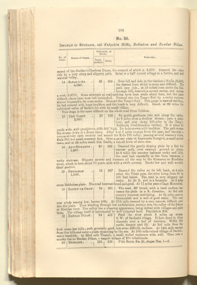
186
No. 36.
Ispahan to Bushahr, via Kuhgehlu Hills, Behbahan and Bandar Dilam.
—
—
Distance, in
MILES.
No. of
statfe.
Names of stages.
Inter*
Total.
Remarks.
mediate.
ascent of the Gardan-i-Chashma Duzar, tlie summit of which is 9.570'. Descend the other
side by a very steep and slippery path 1 " * ’ ’I — : -- J ^
watered valley.
Sadat is a half ruined village in a fertile, and well
14
Safak-i-Ab
4,120'.
309
Over hill and dale to the Gardan-i-Mulla (8,350),
the descent from which is steep and difficult. The
path now (viz., at 10 miles) runs under the Dal-
berangh hill, descends a narrow ravine, and crosses
a neck (5.970'). Some attempts at road-making have been made about here, but the most
difficult places have been left untouched. Descend into the Tang-i-Nali by a rocky staircase
almost impassable for even mules. Descend the Tang-i-Nali. This gorge is narrow and deep,
its bed covered with huge boulders, and the track is very ditficult. Reach at 22 miles the
cultivated valley of Safar-i-Ab with its small village.
This stage is the most ditficult on the whole road from Isfahan.
15
D?h Dasht
2,850'.
23
332
By gentle gradients into and along the valley.
At 6 miles cross a shallow stream ; pass a ceme
tery. and over stony hill-sides to the Tang-i-
Nakhuda (God-forsaken ravine). It is about 70
yards wide, with precipitous cliffs 300' high. Its beds strewn with boulders. The path crosses
the stream down it a dozen times. After 4 or 5 miles emerge from the pass, and traverse a
comparatively open country and ascend the Kala Pili valley, passing several masonry ruins.
Kala Pili is a small masonry fort. Over a grassy plain to Imamzada Dastgird, a small ruined
town, and at 23 miles reach Deh Dasht, a ruined town of some size.
16
17
Ab-i-Rumak0n .
1,400'.
Behbahan
1,300'.
20
352
Descend the gently sloping plain by a fair but
narrow path, over swampy ground in places.
At 8 miles the country becomes rocky and hilly,
the road bad, especially at the Gatz Darwaza, a
rocky staircase. Slippery ascents and descents all the way to the Rumarun or Kurdistan
river, which is here about 70 yards wide with a swift current. Banks low and well wooded.
Good pasture.
Descend the valley on its left bank, at 4 miles
enter the Tekab pass, the river being from 50 to
100 feet below. The road is very slippery and
rooky. At its S. end is a fountain. At 8 miles
The road becomes broad and good. At 11 miles pass village Mansuirab.
15
367
enter Behbahan plain.
18
Zaitun ok Cham
24
391
The road, 30' broad, with a hard surface, tra
verses the plain in a S. direction. At 3rd mile
country becomes undulating. At 8^ miles pass an
Imamzadah and a well of good water. The road
now winds among low, barren hills. At 17th mile descend by a very narrow, difficult path
into the plain. 'Then winding through low undulations, emerge into the valley of the Zaitun
or Hindian river. The valley has a pleasing appearance, being dotted with villages and palm
trees. The village itself is surrounded by well irrigated land. Population 300.
19
Bandab Dilam
24
415
Ford the river about 3 miles up stream
S. W. of Sardasht village. It here flows in three
channels over a bed of boulders. Width 600
_ yards, deepest part 3|'. At 3rd mile from the
ford enter low hills ; path generally good, but some difficult inclines. At 14th mile emerge
from the hills and enter a plain stretching to the sea. At 16th mile ruined village of Daubai;
water brackish. At 22nd mile Thanub, a small walled enclosure with well. Then over a
muddy flat to Bandar Dilam, a seaport village of 200 inhabitants.
26 I Bushahb. . | 124 | 539 | Vide Route No. 21, stages Nos. 1—6.
About this item
- Content
The publication, Routes in Persia, Section I was compiled in the Intelligence Branch of the Quarter-Master Gerneral's Department in India and was published by the Office of the Superintendent of Government Printing, India, Calcutta: 1898.
Section I contains all the routes which commence from the Persian Gulf The historical term used to describe the body of water between the Arabian Peninsula and Iran. littoral and extending to a line drawn from Burajird [Borūjerd], through Isfahan [Eşfahān], Yazd, Karman [Kermān], Khabis [Khabīş], Neh to Lash Juwain [Lāsh-e Juwayn]; the routes have been arranged within the volume by starting from the sea base of the Persian Gulf The historical term used to describe the body of water between the Arabian Peninsula and Iran. and working up towards the line described.
For each route described the previous authorities, such as publications and accounts of journeys, are given, along with the following details:
- Names of stages: towns and villages which act as stopping points along the route;
- The distance in miles from the previous stage of the route;
- The total distance in miles for that route up to that stage;
- Remarks: including geographical information; details on smaller settlements; sacred places; condition of roads; access to water; other roads and routes.
The volume also includes two appendices which contain details of other routes for which the information was received too late to be included in the main body of the volume.
An ink stamp on the front cover records the confidential nature of the publication and that it was being transmitted for the information of His Excellency the Viceroy (Victor Alexander Bruce, 9th Earl of Elgin and 16th Earl of Kincardine) only.
The inside front and back covers have pockets containing index maps of the routes described in the volume.
- Extent and format
- 1 volume (206 folios)
- Arrangement
Folios 6-10 consist of an alphabetical index to names of places featured in the volume, excluding those places which appear in appendix II. Folios 11-17 are an alphabetical cross-index of the routes featured in the volume, again excluding those routes which appear in appendix II.
- Physical characteristics
Foliation: The foliation sequence commences at the front cover, and terminates at the inside back cover; these numbers are written in pencil, are circled, and are located in the top right corner of the recto The front of a sheet of paper or leaf, often abbreviated to 'r'. side of each folio. The volume aso contains an original printed pagination sequence.
- Written in
- English in Latin script View the complete information for this record
Use and share this item
- Share this item
'ROUTES IN PERSIA, Section 1.' [115v] (235/416), British Library: India Office Records and Private Papers, Mss Eur F111/369, in Qatar Digital Library <https://www.qdl.qa/archive/81055/vdc_100025705311.0x000024> [accessed 25 April 2024]
https://www.qdl.qa/en/archive/81055/vdc_100025705311.0x000024
Copy and paste the code below into your web page where you would like to embed the image.
<meta charset="utf-8"><a href="https://www.qdl.qa/en/archive/81055/vdc_100025705311.0x000024">'ROUTES IN PERSIA, Section 1.' [‎115v] (235/416)</a> <a href="https://www.qdl.qa/en/archive/81055/vdc_100025705311.0x000024"> <img src="https://iiif.qdl.qa/iiif/images/81055/vdc_100000001491.0x000111/Mss Eur F111_369_0235.jp2/full/!280,240/0/default.jpg" alt="" /> </a>
This record has a IIIF manifest available as follows. If you have a compatible viewer you can drag the icon to load it.https://www.qdl.qa/en/iiif/81055/vdc_100000001491.0x000111/manifestOpen in Universal viewerOpen in Mirador viewerMore options for embedding images
Copyright: How to use this content
- Reference
- Mss Eur F111/369
- Title
- 'ROUTES IN PERSIA, Section 1.'
- Pages
- front, back, spine, edge, head, tail, front-i, 2r:205v, back-i
- Author
- East India Company, the Board of Control, the India Office, or other British Government Department
- Usage terms
- Open Government Licence