!['ROUTES IN PERSIA, Section 1.' [‎132v] (269/416)](https://iiif.qdl.qa/iiif/images/81055/vdc_100000001491.0x000111/Mss Eur F111_369_0269.jp2/full/!1200,1200/0/default.jpg "'ROUTES IN PERSIA, Section 1.' [‎132v] (269/416)")
'ROUTES IN PERSIA, Section 1.' [132v] (269/416)
The record is made up of 1 volume (206 folios). It was created in 1898. It was written in English. The original is part of the British Library: India Office The department of the British Government to which the Government of India reported between 1858 and 1947. The successor to the Court of Directors. Records and Private Papers Documents collected in a private capacity. .
Transcription
This transcription is created automatically. It may contain errors.
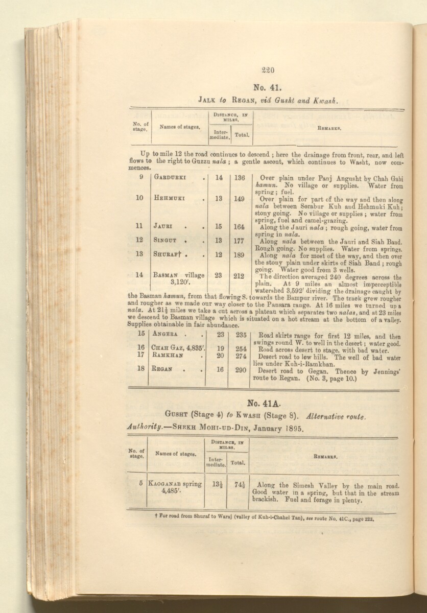
220
No. 41.
Jalk to Reoan, via Gusht, and Kwash.
Distance, in
"" —
No. of
stage.
MILB8.
Names of stages.
Inter
mediate.
Total.
Reuabks,
Up to mile 12 the road continues to descend ; here the drainage from front, rear, and left
flows to the right to Guzzu na/a ; a gentle ascent, which continues to Washt, now com
mences.
Gabdubki . 14 136 Over plain under Panj Angnsht by Chah Gabi
fiamun. No village or supplies. Water from
spring; fuel.
Over plain for part of the way and then along
nala between Sorabur Kuh and Hehmuki Kuh;
stony going. No village or supplies ; water from
spring, fuel and camel-grazing.
Along the Jauri nala ; rough going, water from
spring in nala.
Along nala between the Janri and Siah Baud.
Rough going. No supplies. Water from springs.
Along nala for most of the way, and then over
the stony plain under skirts of Siah Band ; rough
going. Water good from 3 wells.
The direction averaged 240 degrees across the
plain. At 9 miles an almost imperceptible
, watershed 3,592' dividing the drainage caught by
the Basman hamun, from that flowingS. towards the Bampur river. The track grew rougher
and rougher as we made our way closer to the Pansara range. At 16 miles we turned up a
nala. At 21 3 miles we take a cut across a plateau which separates two nalas, and at 23 miles
we descend to Basman village which is situated on a hot stream at the bottom of a valley,
bupphes obtainable in fair abundance.
Road skirts range for first 12 miles, and then
swings round W. to well in the desert; water good.
Road across desert to stage, with bad water.
Desert road to low hills. The well of bad water
lies under Kuh-i-Ramkhan.
Desert road to Gegan, Thence by Jennings’
route to Regan. (No. 3, page 10.)
10
11
12
13
14
Hehmuki
Jaubi
Sin gut
SHUBAF f
Basman village
3,120'.
14
136
13
149
15
164
13
177
12
189
23
U 4 G .
212
15
Angeba .
23
235
16
Chah Gaz, 4,835'.
19
254
17
Ramkhan
20
274
18
Regan
16
290
No. 41A.
Gusht (Stage 4) to Kwasii (Stage 8). Alternative route.
Authority. —Shekh Mohi-ud-Din, January 1895.
No. of
stage.
Names of stages.
Distance, nr
milbs.
Inter
mediate.
Total.
Rbkabks.
5
Kaoganab spring
4,485'.
13*
74*
Along the Simesh Valley by the main road.
Good water in a spring, but that in the stream
brackish. Fuel and forage in plenty.
t For road from Shuraf to Waraj (valley of Kuh-i-Chahel Tan), «« route No. 41C., page 222.
About this item
- Content
The publication, Routes in Persia, Section I was compiled in the Intelligence Branch of the Quarter-Master Gerneral's Department in India and was published by the Office of the Superintendent of Government Printing, India, Calcutta: 1898.
Section I contains all the routes which commence from the Persian Gulf The historical term used to describe the body of water between the Arabian Peninsula and Iran. littoral and extending to a line drawn from Burajird [Borūjerd], through Isfahan [Eşfahān], Yazd, Karman [Kermān], Khabis [Khabīş], Neh to Lash Juwain [Lāsh-e Juwayn]; the routes have been arranged within the volume by starting from the sea base of the Persian Gulf The historical term used to describe the body of water between the Arabian Peninsula and Iran. and working up towards the line described.
For each route described the previous authorities, such as publications and accounts of journeys, are given, along with the following details:
- Names of stages: towns and villages which act as stopping points along the route;
- The distance in miles from the previous stage of the route;
- The total distance in miles for that route up to that stage;
- Remarks: including geographical information; details on smaller settlements; sacred places; condition of roads; access to water; other roads and routes.
The volume also includes two appendices which contain details of other routes for which the information was received too late to be included in the main body of the volume.
An ink stamp on the front cover records the confidential nature of the publication and that it was being transmitted for the information of His Excellency the Viceroy (Victor Alexander Bruce, 9th Earl of Elgin and 16th Earl of Kincardine) only.
The inside front and back covers have pockets containing index maps of the routes described in the volume.
- Extent and format
- 1 volume (206 folios)
- Arrangement
Folios 6-10 consist of an alphabetical index to names of places featured in the volume, excluding those places which appear in appendix II. Folios 11-17 are an alphabetical cross-index of the routes featured in the volume, again excluding those routes which appear in appendix II.
- Physical characteristics
Foliation: The foliation sequence commences at the front cover, and terminates at the inside back cover; these numbers are written in pencil, are circled, and are located in the top right corner of the recto The front of a sheet of paper or leaf, often abbreviated to 'r'. side of each folio. The volume aso contains an original printed pagination sequence.
- Written in
- English in Latin script View the complete information for this record
Use and share this item
- Share this item
'ROUTES IN PERSIA, Section 1.' [132v] (269/416), British Library: India Office Records and Private Papers, Mss Eur F111/369, in Qatar Digital Library <https://www.qdl.qa/archive/81055/vdc_100025705311.0x000046> [accessed 20 April 2024]
https://www.qdl.qa/en/archive/81055/vdc_100025705311.0x000046
Copy and paste the code below into your web page where you would like to embed the image.
<meta charset="utf-8"><a href="https://www.qdl.qa/en/archive/81055/vdc_100025705311.0x000046">'ROUTES IN PERSIA, Section 1.' [‎132v] (269/416)</a> <a href="https://www.qdl.qa/en/archive/81055/vdc_100025705311.0x000046"> <img src="https://iiif.qdl.qa/iiif/images/81055/vdc_100000001491.0x000111/Mss Eur F111_369_0269.jp2/full/!280,240/0/default.jpg" alt="" /> </a>
This record has a IIIF manifest available as follows. If you have a compatible viewer you can drag the icon to load it.https://www.qdl.qa/en/iiif/81055/vdc_100000001491.0x000111/manifestOpen in Universal viewerOpen in Mirador viewerMore options for embedding images
Copyright: How to use this content
- Reference
- Mss Eur F111/369
- Title
- 'ROUTES IN PERSIA, Section 1.'
- Pages
- front, back, spine, edge, head, tail, front-i, 2r:205v, back-i
- Author
- East India Company, the Board of Control, the India Office, or other British Government Department
- Usage terms
- Open Government Licence