!['ROUTES IN PERSIA, Section 1.' [‎202r] (408/416)](https://iiif.qdl.qa/iiif/images/81055/vdc_100000001491.0x000111/Mss Eur F111_369_0408.jp2/full/!1200,1200/0/default.jpg "'ROUTES IN PERSIA, Section 1.' [‎202r] (408/416)")
'ROUTES IN PERSIA, Section 1.' [202r] (408/416)
The record is made up of 1 volume (206 folios). It was created in 1898. It was written in English. The original is part of the British Library: India Office The department of the British Government to which the Government of India reported between 1858 and 1947. The successor to the Court of Directors. Records and Private Papers Documents collected in a private capacity. .
Transcription
This transcription is created automatically. It may contain errors.
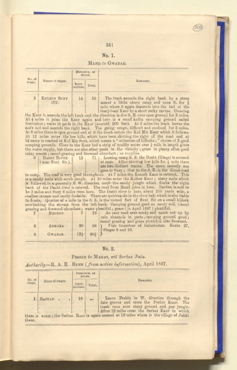
861
No. 1.
Mand to Gwadar.
No. of
stage.
Names of stages.
Kulmib Sunt
175'.
Distahce, IK
MILES.
Inter
mediate.
14
Total.
59
Remabks.
The track ascends the right bank by a steep
ascent a little above camp and runs S. for |
mile where it again descends into the bed of the
Ganj-i-ani Kaur by a short rocky ravine. Crossing
the Kaur it ascends the left bank and the direction is due S. E. over open ground for 3 miles.
At 4 miles it joins the Kaur again and here is a small
kafila
A train of travellers; a caravan; or any large party of travellers.
camping ground called
Itezinabaz ; water in pools in the Kaur (aneroid 200 feet). At 5 miles the track leaves the
nala bed and ascends the right bank. The going rough, difficult and confined for 3 miles.
At 8 miles there is open ground and at 9 the track enters the Kul Mir Kaur which it follows.
At 12 miles enter the low hills, which have been skirting the right of the road and at
14 camp is reached at Kul Mir Sunt, which means a “ collection of hillocks; ” choice of 3 good
camping grounds. Close to the Kaur bed a strip of muddy water over £ mile in length gives
the water supply, but there are also other pools in the vicinity ; grass in plenty after good
rainv season : camel crazinfr and firewood abundant ; no Supplies.
Leaving camp S. E. the Dasbt (lllaqa) is entered
at once. After skirting low hills for ^ mile there
are two distinct tracks. The more easterly one
goes to Suey ; that to the S. E. is the direct road
to camp. The road is very good throughout. At 7 miles the Kasach Kaur is entered. This
is a sandy nala with scrub jungle. At 10 miles enter the Kalkar Kaur ; stony nala which
is followed in a generally S W. direction until the sandy jungle which flanks the right
bank of the Dasht river is entered. The road from Mand joins in here. Dardan is said to
be 3 miles and Suey 6 miles from here. The Dasht river is here, about 100 yards wide, a
shallow stream and easily fordable. There are quicksands in the river bed, which is also liable
to floods. Quarter of a mile to the S. E. is the ruined fort of Sunt Sir on a small hillock
overlooking the stream from the left bank. Camping ground good on sandy soil. Camel
grazing and firewood abundant; water plentiful; grass (in April 1897 ) plentiful.
An easy road over sandy soil much cut up by
rain channels in parts ; camping ground good ;
camel grazing and grass plentiful, also firewood.
i Vide Gazetteer of Baluchistan. Route 27,
'-Stages 9 and 10.
Dasht Riveb
12
71
( near Sunt Sir ).
.
7
Meshod
7
78
8
Ankoba
20
98
9
Gwadab
ISa
90 £
No. 2.
Peshin to Magas, vid Sarbaz Nala .
Authority — R. A. E. Benn [from native information), April 1897.
Ne. of
stage.
Distance, in
miles.
Name of stages.
Inter
mediate.
Total.
Bbmabzs.
1
there is
Baftan .
water; the Sarbas
18
Kaur
is agai
Leave Peshin in W. direction through the
date groves and cross the Peshin Kaur. The
track runs over stony ground and gaz jungle.
After 12 miles cross the Sarbaz Kaur in which
n crossed at 13 miles where is the village of Jakki
Gwar.
About this item
- Content
The publication, Routes in Persia, Section I was compiled in the Intelligence Branch of the Quarter-Master Gerneral's Department in India and was published by the Office of the Superintendent of Government Printing, India, Calcutta: 1898.
Section I contains all the routes which commence from the Persian Gulf The historical term used to describe the body of water between the Arabian Peninsula and Iran. littoral and extending to a line drawn from Burajird [Borūjerd], through Isfahan [Eşfahān], Yazd, Karman [Kermān], Khabis [Khabīş], Neh to Lash Juwain [Lāsh-e Juwayn]; the routes have been arranged within the volume by starting from the sea base of the Persian Gulf The historical term used to describe the body of water between the Arabian Peninsula and Iran. and working up towards the line described.
For each route described the previous authorities, such as publications and accounts of journeys, are given, along with the following details:
- Names of stages: towns and villages which act as stopping points along the route;
- The distance in miles from the previous stage of the route;
- The total distance in miles for that route up to that stage;
- Remarks: including geographical information; details on smaller settlements; sacred places; condition of roads; access to water; other roads and routes.
The volume also includes two appendices which contain details of other routes for which the information was received too late to be included in the main body of the volume.
An ink stamp on the front cover records the confidential nature of the publication and that it was being transmitted for the information of His Excellency the Viceroy (Victor Alexander Bruce, 9th Earl of Elgin and 16th Earl of Kincardine) only.
The inside front and back covers have pockets containing index maps of the routes described in the volume.
- Extent and format
- 1 volume (206 folios)
- Arrangement
Folios 6-10 consist of an alphabetical index to names of places featured in the volume, excluding those places which appear in appendix II. Folios 11-17 are an alphabetical cross-index of the routes featured in the volume, again excluding those routes which appear in appendix II.
- Physical characteristics
Foliation: The foliation sequence commences at the front cover, and terminates at the inside back cover; these numbers are written in pencil, are circled, and are located in the top right corner of the recto The front of a sheet of paper or leaf, often abbreviated to 'r'. side of each folio. The volume aso contains an original printed pagination sequence.
- Written in
- English in Latin script View the complete information for this record
Use and share this item
- Share this item
'ROUTES IN PERSIA, Section 1.' [202r] (408/416), British Library: India Office Records and Private Papers, Mss Eur F111/369, in Qatar Digital Library <https://www.qdl.qa/archive/81055/vdc_100025705312.0x000009> [accessed 18 April 2024]
https://www.qdl.qa/en/archive/81055/vdc_100025705312.0x000009
Copy and paste the code below into your web page where you would like to embed the image.
<meta charset="utf-8"><a href="https://www.qdl.qa/en/archive/81055/vdc_100025705312.0x000009">'ROUTES IN PERSIA, Section 1.' [‎202r] (408/416)</a> <a href="https://www.qdl.qa/en/archive/81055/vdc_100025705312.0x000009"> <img src="https://iiif.qdl.qa/iiif/images/81055/vdc_100000001491.0x000111/Mss Eur F111_369_0408.jp2/full/!280,240/0/default.jpg" alt="" /> </a>
This record has a IIIF manifest available as follows. If you have a compatible viewer you can drag the icon to load it.https://www.qdl.qa/en/iiif/81055/vdc_100000001491.0x000111/manifestOpen in Universal viewerOpen in Mirador viewerMore options for embedding images
Copyright: How to use this content
- Reference
- Mss Eur F111/369
- Title
- 'ROUTES IN PERSIA, Section 1.'
- Pages
- front, back, spine, edge, head, tail, front-i, 2r:205v, back-i
- Author
- East India Company, the Board of Control, the India Office, or other British Government Department
- Usage terms
- Open Government Licence