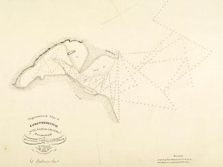
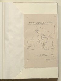
'SKETCH MAP TO ACCOMPANY REPORT ON TRADE OF BAHREIN ISLANDS'
IOR/R/15/2/952, f 9
2 items in this record
Search within this record
The record is made up of 1 map sheet. It was created in 1915. It was written in English. The original is part of the British Library: India Office The department of the British Government to which the Government of India reported between 1858 and 1947. The successor to the Court of Directors. Records and Private Papers Documents collected in a private capacity. .
About this record
- Content
Sketch Map showing Bahrain's location in the Persian Gulf The historical term used to describe the body of water between the Arabian Peninsula and Iran. in relation to Qatar and Saudi Arabia.
The map was reproduced from the Ordnance Survey, Southampton 1915.
- Extent and format
- 1 map sheet
- Area map covers
- Map loading...
- Scale
- 1:32
- Scale designator
- Horizontal
- Orientation
- North
- Degree coordinates
- Top-left: 26° 51' 3.96" N, 49° 8' 46.68" E
Top-right: 26° 51' 3.96" N, 51° 51' 56.88" E
Bottom-left: 23° 57' 28.08" N, 49° 8' 46.68" E
Bottom-right: 23° 57' 28.08" N, 51° 51' 56.88" E - It is part of
- 756 imagesRef: IOR/R/15/2/952
- Physical characteristics
Foliation: A pencil number, enclosed in a circle, is located in the top right hand corner of the recto The front of a sheet of paper or leaf, often abbreviated to 'r'. of the folio.
Materials: 1 parchment sheet
Dimensions: 245 x 160 mm
- Written in
- English in Latin script
- Type
- Map
Archive information for this record
- Original held at
- British Library: India Office The department of the British Government to which the Government of India reported between 1858 and 1947. The successor to the Court of Directors. Records and Private Papers Documents collected in a private capacity.
- Access conditions
Unrestricted
- Archive reference
- IOR/R/15/2/952, f 9
- Date(s)
- 1915 (CE, Gregorian)
Access & Reference
History of this record
Related search terms
- Places
- QatarSaudi Arabia
Use and share this record
- Share this record
- Cite this record in your research
'SKETCH MAP TO ACCOMPANY REPORT ON TRADE OF BAHREIN ISLANDS', British Library: India Office Records and Private Papers, IOR/R/15/2/952, f 9, in Qatar Digital Library <https://www.qdl.qa/archive/81055/vdc_100025782757.0x000002> [accessed 18 April 2024]
- Link to this record
https://www.qdl.qa/en/archive/81055/vdc_100025782757.0x000002
- IIIF details
This record has a IIIF manifest available as follows. If you have a compatible viewer you can drag the icon to load it.https://www.qdl.qa/en/iiif/81055/vdc_100000000241.0x0001af/manifestOpen in Universal viewerOpen in Mirador viewerMore options for embedding images
Copyright: How to use this content
- Reference
- IOR/R/15/2/952, f 9
- Title
- 'SKETCH MAP TO ACCOMPANY REPORT ON TRADE OF BAHREIN ISLANDS'
- Pages
- 9r:9v
- Author
- Ordnance Survey Office
- Usage terms
- Public Domain