'APPENDIX C. MAP SHOWING THE EXTENT OF WAHABI AND OF MUSCAT POWER, 1865.'
IOR/L/PS/18/B437, f 30


2 items in this record
Search within this record
The record is made up of 1 map. It was created in 1934. It was written in English. The original is part of the British Library: India Office The department of the British Government to which the Government of India reported between 1858 and 1947. The successor to the Court of Directors. Records and Private Papers Documents collected in a private capacity. .
About this record
- Content
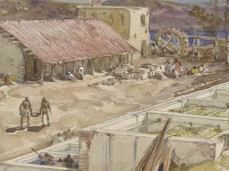
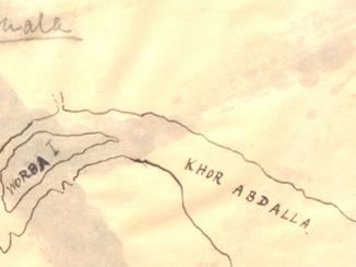
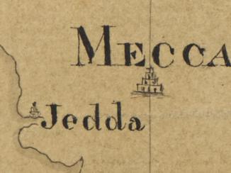
A map of the Arabian Peninsula, showing principal regions and settlements, and indicating with red and blue outlines the extents of Wahabi and of Muscat power respectively. The map is a printed copy of an enclosure from Bushire Despatch to Bombay No. 11 of 14th February 1865, which was created by the Political Resident A senior ranking political representative (equivalent to a Consul General) from the diplomatic corps of the Government of India or one of its subordinate provincial governments, in charge of a Political Residency. in the Persian Gulf The historical term used to describe the body of water between the Arabian Peninsula and Iran. .
- Extent and format
- 1 map
- Area map covers
- Map loading...
- Scale
- Scale not given
- Scale designator
- Horizontal
- Orientation
- North
- Degree coordinates
- Top-left: 29° 37' 42.24" N, 34° 32' 56.4" E
Top-right: 29° 37' 42.24" N, 60° 12' 18.36" E
Bottom-left: 12° 13' 57.72" N, 34° 32' 56.4" E
Bottom-right: 12° 13' 57.72" N, 60° 12' 18.36" E - It is part of
- 64 imagesRef: IOR/L/PS/18/B437
- Physical characteristics
Materials: Printed on paper
Dimensions: 334 x 430mm
- Written in
- English in Latin script
- Type
- Map
Archive information for this record
- Original held at
- British Library: India Office The department of the British Government to which the Government of India reported between 1858 and 1947. The successor to the Court of Directors. Records and Private Papers Documents collected in a private capacity.
- Access conditions
Unrestricted
- Archive reference
- IOR/L/PS/18/B437, f 30
- Date(s)
- 1934 (CE, Gregorian)
Access & Reference
History of this record
Related search terms
- Places
- Arabian Peninsula
- People & organisations
- Political Resident, Persian GulfGovernment of Oman
Use and share this record
- Share this record
- Cite this record in your research
'APPENDIX C. MAP SHOWING THE EXTENT OF WAHABI AND OF MUSCAT POWER, 1865.', British Library: India Office Records and Private Papers, IOR/L/PS/18/B437, f 30, in Qatar Digital Library <https://www.qdl.qa/archive/81055/vdc_100030950037.0x000001> [accessed 25 April 2024]
- Link to this record
https://www.qdl.qa/en/archive/81055/vdc_100030950037.0x000001
- IIIF details
This record has a IIIF manifest available as follows. If you have a compatible viewer you can drag the icon to load it.https://www.qdl.qa/en/iiif/81055/vdc_100000000833.0x00004c/manifestOpen in Universal viewerOpen in Mirador viewerMore options for embedding images
Copyright: How to use this content
- Reference
- IOR/L/PS/18/B437, f 30
- Title
- 'APPENDIX C. MAP SHOWING THE EXTENT OF WAHABI AND OF MUSCAT POWER, 1865.'
- Pages
- 30r:30v
- Author
- East India Company, the Board of Control, the India Office, or other British Government Department
- Usage terms
- Open Government Licence