!['ROUGH SKETCH SHOWING PROBABLE RIVER SYSTEM NEAR MOHAMMERAH ABOUT 1750.' [‎74r] (1/2)](https://iiif.qdl.qa/iiif/images/81055/vdc_100000000419.0x00009f/IOR_L_PS_10_266_0161.jp2/full/!1200,1200/0/default.jpg "'ROUGH SKETCH SHOWING PROBABLE RIVER SYSTEM NEAR MOHAMMERAH ABOUT 1750.' [‎74r] (1/2)")
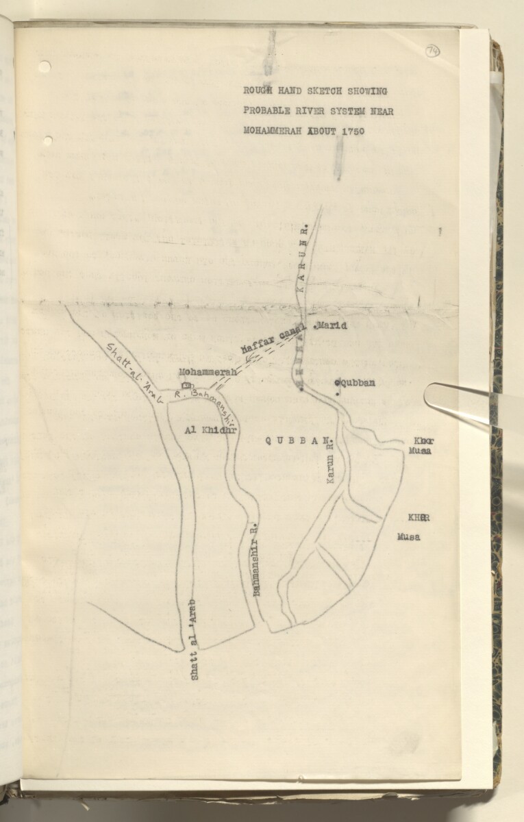
'ROUGH SKETCH SHOWING PROBABLE RIVER SYSTEM NEAR MOHAMMERAH ABOUT 1750.' [74r] (1/2)
The record is made up of 1 map. It was created in [1912]. It was written in English. The original is part of the British Library: India Office The department of the British Government to which the Government of India reported between 1858 and 1947. The successor to the Court of Directors. Records and Private Papers Documents collected in a private capacity. .
Transcription
This transcription is created automatically. It may contain errors.
- in.. _
ROUGH HAHD SKETCH SHOWUfG
PROBABLE RIVER SYSTEM HEAR
MOHAMMERAH IBOUT 1750
About this item
- Content
Sketch of the river system near Mohammerah [Khorramshahr] with coastlines and rivers drawn in pencil and place names typed over the drawing. Names of rivers have been written in ink.
The sketch was included in notes on Alwyn Parker's memorandum respecting the frontier between Mohammerah and Turkey, written by Sir Percy Zachariah Cox.
- Extent and format
- 1 map
- Area map covers
- Map loading...
- Scale
- No scale
- Scale designator
- Horizontal
- Orientation
- North
- Degree coordinates
- Top-left: 30° 32' 5.9" N, 48° 7' 24.98" E
Top-right: 30° 32' 5.9" N, 48° 43' 11.16" E
Bottom-left: 29° 53' 1.68" N, 48° 7' 24.98" E
Bottom-right: 29° 53' 1.68" N, 48° 43' 11.16" E - Physical characteristics
Dimensions: 330mm x 200mm
Materials: 1 paper folio
- Written in
- English in Latin script View the complete information for this record
Use and share this item
- Share this item
'ROUGH SKETCH SHOWING PROBABLE RIVER SYSTEM NEAR MOHAMMERAH ABOUT 1750.' [74r] (1/2), British Library: India Office Records and Private Papers, IOR/L/PS/10/266, f 74, in Qatar Digital Library <https://www.qdl.qa/archive/81055/vdc_100036171270.0x00009e> [accessed 25 April 2024]
https://www.qdl.qa/en/archive/81055/vdc_100036171270.0x00009e
Copy and paste the code below into your web page where you would like to embed the image.
<meta charset="utf-8"><a href="https://www.qdl.qa/en/archive/81055/vdc_100036171270.0x00009e">'ROUGH SKETCH SHOWING PROBABLE RIVER SYSTEM NEAR MOHAMMERAH ABOUT 1750.' [‎74r] (1/2)</a> <a href="https://www.qdl.qa/en/archive/81055/vdc_100036171270.0x00009e"> <img src="https://iiif.qdl.qa/iiif/images/81055/vdc_100000000419.0x00009f/IOR_L_PS_10_266_0161.jp2/full/!280,240/0/default.jpg" alt="" /> </a>
This record has a IIIF manifest available as follows. If you have a compatible viewer you can drag the icon to load it.https://www.qdl.qa/en/iiif/81055/vdc_100000000419.0x00009f/manifestOpen in Universal viewerOpen in Mirador viewerMore options for embedding images
Copyright: How to use this content
- Reference
- IOR/L/PS/10/266, f 74
- Title
- 'ROUGH SKETCH SHOWING PROBABLE RIVER SYSTEM NEAR MOHAMMERAH ABOUT 1750.'
- Pages
- 74r:74v
- Author
- East India Company, the Board of Control, the India Office, or other British Government Department
- Usage terms
- Open Government Licence